
پرونده:Cordón del Azufre.jpg
تفکیکپذیری بالاتری در دسترس نیست.
Cordón_del_Azufre.jpg (۶۴۰ × ۴۲۲ پیکسل، اندازهٔ پرونده: ۷۴ کیلوبایت، نوع MIME پرونده: image/jpeg)
این پرونده در ویکیانبار موجود است. محتویات صفحهٔ توصیف آن در زیر نمایش داده میشود. |
خلاصه
| توضیح |
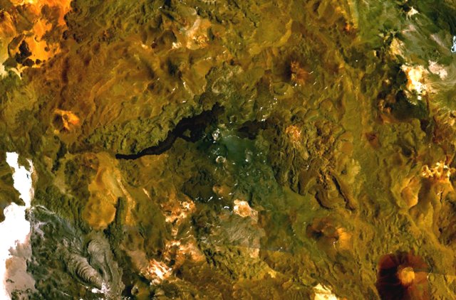
English: The volcanic complex in the center of this NASA Landsat composite image is Cordón del Azufre, a small volcanic center straddling the Chile-Argentina border. A dacitic lava-dome complex lies at the eastern side of the complex, in Argentina. The prominent dark-colored lava flow from Volcán la Moyra, the youngest feature of the volcanic field, descended 6 km into Chile and 3 km into Argentina. Lava flows from Bayo volcano to the SW are visible at the lower left. |
| تاریخ | تاریخ نامعلوم |
| منبع | http://www.volcano.si.edu/world/volcano.cfm?vnum=1505-121&volpage=photos&photo=115040 |
| پدیدآور | NASA Landsat7 image (worldwind.arc.nasa.gov) |
اجازهنامه
| این تصویر در مالکیت عمومی قرار دارد به این دلیل که از نرمافزار زمین ناسا World Wind با استفاده یک لایهٔ مالکیت عمومی، از قبیل Blue Marble، MODIS، Landsat، SRTM، USGS یا GLOBE گرفته شده است.
|
 |
تاریخچهٔ پرونده
روی تاریخ/زمانها کلیک کنید تا نسخهٔ مربوط به آن هنگام را ببینید.
| تاریخ/زمان | بندانگشتی | ابعاد | کاربر | توضیح | |
|---|---|---|---|---|---|
| کنونی | ۱۶ اکتبر ۲۰۱۰، ساعت ۱۹:۰۲ | | ۶۴۰ در ۴۲۲ (۷۴ کیلوبایت) | Michael Metzger | {{Information |Description={{en|1=The volcanic complex in the center of this NASA Landsat composite image is Cordón del Azufre, a small volcanic center straddling the Chile-Argentina border. A dacitic lava-dome complex lies at the eastern side of the com |
کاربرد پرونده
صفحهٔ زیر از این تصویر استفاده میکند:
کاربرد سراسری پرونده
ویکیهای دیگر زیر از این پرونده استفاده میکنند:
- کاربرد در arz.wikipedia.org
- کاربرد در ceb.wikipedia.org
- کاربرد در de.wikipedia.org
- کاربرد در en.wikipedia.org
- کاربرد در es.wikipedia.org
- کاربرد در eu.wikipedia.org
- کاربرد در fr.wikipedia.org
- کاربرد در hu.wikipedia.org
- کاربرد در id.wikipedia.org
- کاربرد در lld.wikipedia.org
- کاربرد در ms.wikipedia.org
- کاربرد در pl.wikipedia.org
- کاربرد در sk.wikipedia.org
- کاربرد در sv.wikipedia.org
- کاربرد در www.wikidata.org
- کاربرد در zh.wikipedia.org