پرونده:ComparisonOfPiriReis1513MapTo1502CantinoPlanisphere.png

Page contents not supported in other languages.
از ویکی‌پدیا، دانشنامهٔ آزاد

پروندهٔ اصلی(۶٬۰۰۰ × ۴٬۹۹۸ پیکسل، اندازهٔ پرونده: ۵۰٫۸۶ مگابایت، نوع MIME پرونده: image/png)

خلاصه

توضیح
English: This uses these two public domain source images:
  • File:Piri reis world map 01.jpg
  • File:Cantino planisphere (1502).jpg

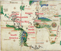
The black lines are derived from the Piri Reis 1513 map fragment. Red captions label places depicted in similar locations on both maps. The position of Africa's Atlantic coast and the Atlantic islands are very similar. Europe is roughly similar. The position of South America is similar in both maps, but the Piri Reis map has considerably more detail. There is debate over what the islands and bays bordering Piri Reis' Atlantic represent. The Cantino Planisphere depicts the Caribbean according to the 1500 map of Juan de la Cosa. Piri Reis depicts the Carribean based on an earlier lost map from Columbus, reflecting Columbus' belief that Cuba was part of Asian mainland and that the island of Hispaniola was Cipango, Marco Polo's Japan, depicted on contemporary maps of Asia. The peninsula extending from an American mainland in the Planisphere may be based on the "mainland" Cuba misconception. The areas North and West of Brittany were on portions of the Piri Reis map thought to be lost.

Place names in the Caribbean:

  • Puerto Rico: boriquem (Boriquén, the native Taíno name for Puerto Rico), Sanjuwano bastido (San Juan Bastido, an early name for Puerto Rico)
  • Hispaniola: ilha espanholia (Isle Hispaniola), Elcezire Izle despanya (The Island called Isla de Españiola)
  • Cuba: Ilha Yssabella (Isle Isabella), Porta Ghande (Puerto Grande, an early name for Guantanamo Bay)
  • Red text overlay, text visible from Cantino Planisphere, text transliterated from the Piri Reis map

Additional sources:

  • Gaspar, Joaquim Alves (2015), "The Representation of the West Indies in Early Iberian Cartography: A Cartometric Approach", Terrae Incognitae, 47 (1): 10-32, doi:10.1179/0082288415Z.00000000041 .
  • McIntosh, Gregory C. (2000), The Piri Reis Map of 1513, Athens, Georgia: University of Georgia Press, ISBN 0-8203-2157-5.
  • Soucek, Svat (1996), Piri Reis and Turkish Mapmaking after Columbus: The Khalili Portolan Atlas, London and New York: Nour Foundation and Azimuth Editions.
  • Vescelius, Gary S., Cinquino, Michael A., Tronolone, Carmine and Vandrei, Charles (2007), "Historic Resources on the Vieques Naval Reservation and the Historical Development of Vieques Island", Ecology and Environment: Puerto Rico.
تاریخ
منبع اثر شخصی
پدیدآور Rjjiii

اجازه‌نامه

من، صاحب حقوق قانونی این اثر، به این وسیله این اثر را تحث اجازه‌نامهٔ ذیل منتشر می‌کنم:
w:fa:کرییتیو کامنز
انتساب انتشار مشابه
این پرونده تحت پروانهٔ Creative Commons Attribution-Share Alike 4.0 International منتشر شده است.
شما اجازه دارید:
  • برای به اشتراک گذاشتن – برای کپی، توزیع و انتقال اثر
  • تلفیق کردن – برای انطباق اثر
تحت شرایط زیر:
  • انتساب – شما باید اعتبار مربوطه را به دست آورید، پیوندی به مجوز ارائه دهید و نشان دهید که آیا تغییرات ایجاد شده‌اند یا خیر. شما ممکن است این کار را به هر روش منطقی انجام دهید، اما نه به هر شیوه‌ای که پیشنهاد می‌کند که مجوزدهنده از شما یا استفاده‌تان حمایت کند.
  • انتشار مشابه – اگر این اثر را تلفیق یا تبدیل می‌کنید، یا بر پایه‌ آن اثری دیگر خلق می‌کنید، می‌‌بایست مشارکت‌های خود را تحت مجوز یکسان یا مشابه با ا اصل آن توزیع کنید.

عنوان

شرحی یک‌خطی از محتوای این فایل اضافه کنید
A comparison of the 1513 Piri Reis map (black lines) against a section of the 1503 Cantino Planisphere

آیتم‌هایی که در این پرونده نمایش داده شده‌اند

توصیف‌ها

این خصوصیت مقداری دارد اما نامشخص است.

source of file انگلیسی

checksum انگلیسی

7bc419952d8c2562f40c5ace6749c56a4fff056b

۵۳٬۳۲۵٬۴۵۶ بایت

۴٬۹۹۸ پیکسل

۶٬۰۰۰ پیکسل

تاریخچهٔ پرونده

روی تاریخ/زمان‌ها کلیک کنید تا نسخهٔ مربوط به آن هنگام را ببینید.

تاریخ/زمانبندانگشتیابعادکاربرتوضیح
کنونی‏۳۰ ژوئیهٔ ۲۰۲۳، ساعت ۰۲:۴۲تصویر بندانگشتی از نسخهٔ مورخ ‏۳۰ ژوئیهٔ ۲۰۲۳، ساعت ۰۲:۴۲۶٬۰۰۰ در ۴٬۹۹۸ (۵۰٫۸۶ مگابایت)RjjiiiSubtle cleanup
‏۲۹ ژوئیهٔ ۲۰۲۳، ساعت ۱۸:۴۳تصویر بندانگشتی از نسخهٔ مورخ ‏۲۹ ژوئیهٔ ۲۰۲۳، ساعت ۱۸:۴۳۶٬۰۰۰ در ۴٬۹۹۸ (۵۰٫۸۵ مگابایت)RjjiiiMake text more legible, especially in thumbnails
‏۱۳ مهٔ ۲۰۲۳، ساعت ۱۹:۰۳تصویر بندانگشتی از نسخهٔ مورخ ‏۱۳ مهٔ ۲۰۲۳، ساعت ۱۹:۰۳۶٬۰۰۰ در ۴٬۹۹۸ (۵۷٫۷۸ مگابایت)Rjjiiibetter visibility and color fidelity
‏۱۳ مهٔ ۲۰۲۳، ساعت ۱۸:۳۷تصویر بندانگشتی از نسخهٔ مورخ ‏۱۳ مهٔ ۲۰۲۳، ساعت ۱۸:۳۷۶٬۰۰۰ در ۴٬۹۹۸ (۴۲٫۵۱ مگابایت)RjjiiiUploaded own work with UploadWizard

صفحهٔ زیر از این تصویر استفاده می‌کند:

کاربرد سراسری پرونده

ویکی‌های دیگر زیر از این پرونده استفاده می‌کنند:

فراداده