
پرونده:Chaparrastique.jpg
تفکیکپذیری بالاتری در دسترس نیست.
Chaparrastique.jpg (۶۴۰ × ۴۳۲ پیکسل، اندازهٔ پرونده: ۷۷ کیلوبایت، نوع MIME پرونده: image/jpeg)
این پرونده در ویکیانبار موجود است. محتویات صفحهٔ توصیف آن در زیر نمایش داده میشود. |
| توضیح |
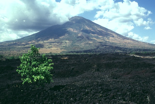
English: This sparsely vegetated basaltic lava flow was erupted from a fissure vent on the lower SE flank of San Miguel in 1819. The flow covers a broad 2.5-km-wide, 5-km-long area on the low-angle slopes below the volcano and reaches down to an elevation of less than 40 m above sea level. The principal coastal highway of El Salvador traverses the flow below the point of this photo, and the national railway crosses the flow closer to the vent. |
|||
| تاریخ | ||||
| منبع | http://www.volcano.si.edu/world/volcano.cfm?vnum=1403-10=&volpage=photos&photo=076042 | |||
| پدیدآور | Lee Siebert (Smithsonian Institution) | |||
| اجازهنامه (استفادهٔ مجدد از این پرونده) |
|
تاریخچهٔ پرونده
روی تاریخ/زمانها کلیک کنید تا نسخهٔ مربوط به آن هنگام را ببینید.
| تاریخ/زمان | بندانگشتی | ابعاد | کاربر | توضیح | |
|---|---|---|---|---|---|
| کنونی | ۲۳ ژوئیهٔ ۲۰۱۰، ساعت ۲۱:۳۷ | | ۶۴۰ در ۴۳۲ (۷۷ کیلوبایت) | Michael Metzger | {{Information |Description={{en|1=This sparsely vegetated basaltic lava flow was erupted from a fissure vent on the lower SE flank of San Miguel in 1819. The flow covers a broad 2.5-km-wide, 5-km-long area on the low-angle slopes below the volcano and rea |
کاربرد پرونده
صفحهٔ زیر از این تصویر استفاده میکند:
کاربرد سراسری پرونده
ویکیهای دیگر زیر از این پرونده استفاده میکنند:
- کاربرد در az.wikipedia.org
- کاربرد در be.wikipedia.org
- کاربرد در ca.wikipedia.org
- کاربرد در de.wikipedia.org
- کاربرد در fr.wikipedia.org
- کاربرد در hy.wikipedia.org
- کاربرد در ru.wikipedia.org
- کاربرد در simple.wikipedia.org
- کاربرد در uk.wikipedia.org