
پرونده:Cape Kazantip, Kerch Peninsula, Southern Sea of Azov, Ukraine.JPG

پروندهٔ اصلی (۶٬۰۴۸ × ۴٬۰۲۸ پیکسل، اندازهٔ پرونده: ۳٫۹۶ مگابایت، نوع MIME پرونده: image/jpeg)
این پرونده در ویکیانبار موجود است. محتویات صفحهٔ توصیف آن در زیر نمایش داده میشود. |
خلاصه
| توضیح |
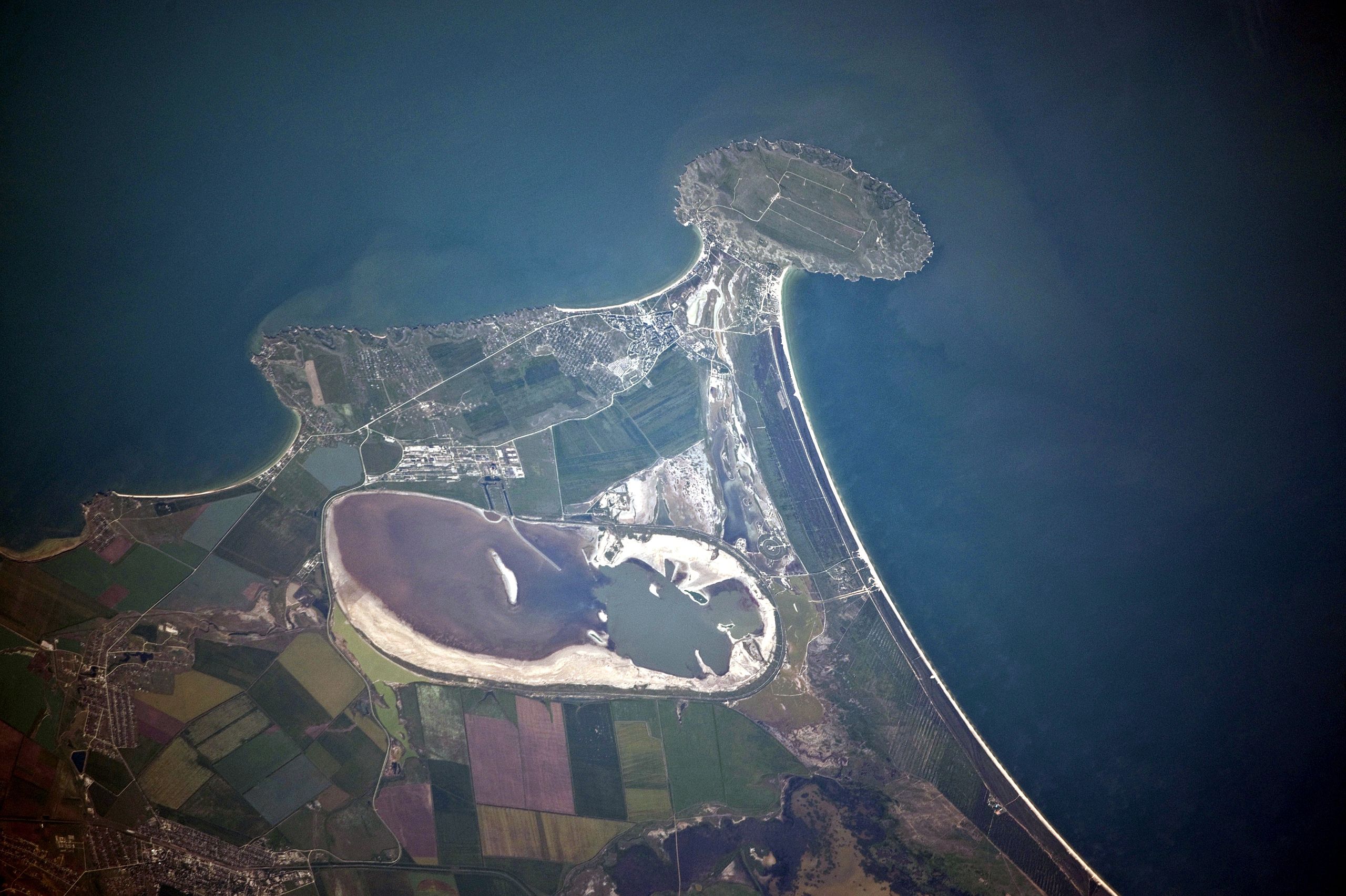
English: Cape Kazantip is a prominent headland on the Kerch Peninsula, which defines the southern shore of the Sea of Azov and the east extension of the Crimean Peninsula. During the Second World War, German and Soviet forces fought on the Kerch Peninsula, with the line of battle impinging on areas shown at the bottom of the image. The distance from the tip of the Cape to the largest local city, Lenine (population ~70,000, image lower left) is only 20 kilometres.
Français : A l'est de la péninsule de Crimée, Cap Kazantip est un promontoire sur la péninsule de Kertch, sur la rive sud de la mer d'Azov. Pendant la Seconde Guerre mondiale, les forces allemandes et soviétiques se sont battus sur la péninsule de Kertch. De la pointe du Cap à plus grande ville locale, Lenine (population ~ 70 000), il y a 20 kilomètres. Une centrale nucléaire en construction a été suspendue en 1989, suite à la chute du bloc soviétique. |
| تاریخ | |
| منبع | NASA Earth Observatory |
| پدیدآور | ISS Expedition 23 crew |
| مختصات دوربین | | محل قرارگیری این نگاره و سایر نگارهها در: نقشهٔ شهری باز |
|---|
این نگاره یا ویدیو توسط مرکز فضایی جانسون سازمان ملی هوانوردی و فضایی (NASA)ایالات متحدهٔ آمریکا تحت شناسهٔ عکس: ISS023-E-56842کاتالوگ شدهاست. این برچست وضعیت حق تکثیر اثر ضمیمه شده را مشخص نمیکند. یک برچسپ معمولی همچنان مورد نیاز است. Commons:Licensing را برای کسب اطلاعات مشاهده فرمایید. زبانهای دیگر:
|
This detailed astronaut photograph was taken from the International Space Station (ISS) when it was located 400 kilometres to the north-east, but due to the long (800 mm) lens used, the photo includes detailed field patterns and city blocks. Green and brown fields show intensive agricultural activity in the area, and salt ponds are visible at the west end of the shallow Lake Aktashskoye at image centre.
اجازهنامه
| این پرونده در مالکیت عمومی قرار دارد چرا که توسط ناسا ایجاد شده است. سیاست حق تکثیر ناسا بیان میکند که «مواد ناسا با حق تکثیر محافظت نمیشوند، مگراینکه ذکر شده باشد». (Template:PD-USGov، صفحهٔ سیاست حق تکثیر ناسا یا سیاست جیپیال استفاده از تصاویر را ببینید.) | ||
 |
هشدارها:
|
| برچسبها | این نگاره برچسپگذاری شدهاست: برچسپها را در ویکیانبار مشاهده کنید |
تاریخچهٔ پرونده
روی تاریخ/زمانها کلیک کنید تا نسخهٔ مربوط به آن هنگام را ببینید.
| تاریخ/زمان | بندانگشتی | ابعاد | کاربر | توضیح | |
|---|---|---|---|---|---|
| کنونی | ۲۰ ژوئیهٔ ۲۰۱۰، ساعت ۱۲:۴۲ | | ۶٬۰۴۸ در ۴٬۰۲۸ (۳٫۹۶ مگابایت) | Originalwana | {{Information |Description={{en|1=Cape Kazantip is a prominent headland on the Kerch Peninsula, which defines the southern shore of the Sea of Azov and the east extension of the Crimean Peninsula. During the [[World W |
کاربرد پرونده
صفحهٔ زیر از این تصویر استفاده میکند:
کاربرد سراسری پرونده
ویکیهای دیگر زیر از این پرونده استفاده میکنند:
- کاربرد در arz.wikipedia.org
- کاربرد در az.wikipedia.org
- کاربرد در be.wikipedia.org
- کاربرد در ceb.wikipedia.org
- کاربرد در crh.wikipedia.org
- کاربرد در de.wikipedia.org
- کاربرد در en.wikipedia.org
- کاربرد در eo.wikipedia.org
- کاربرد در es.wikipedia.org
- کاربرد در fi.wikipedia.org
- کاربرد در fr.wikipedia.org
- کاربرد در hr.wikipedia.org
- کاربرد در hy.wikipedia.org
- کاربرد در ka.wikipedia.org
- کاربرد در nn.wikipedia.org
- کاربرد در pl.wikipedia.org
- کاربرد در ro.wikipedia.org
- کاربرد در ru.wikipedia.org
- کاربرد در ru.wikivoyage.org
- کاربرد در uk.wikipedia.org
- کاربرد در www.wikidata.org