
پرونده:CH-24 WAC 41 North.png
اندازهٔ این پیشنمایش: ۸۰۰ × ۲۹۹ پیکسل. کیفیتهای دیگر: ۳۲۰ × ۱۲۰ پیکسل | ۶۴۰ × ۲۳۹ پیکسل | ۱٬۰۲۴ × ۳۸۳ پیکسل | ۱٬۲۸۰ × ۴۷۸ پیکسل | ۵٬۳۵۴ × ۲٬۰۰۰ پیکسل.
پروندهٔ اصلی (۵٬۳۵۴ × ۲٬۰۰۰ پیکسل، اندازهٔ پرونده: ۶٫۰۲ مگابایت، نوع MIME پرونده: image/png)
این پرونده در ویکیانبار موجود است. محتویات صفحهٔ توصیف آن در زیر نمایش داده میشود. |
| توضیح |
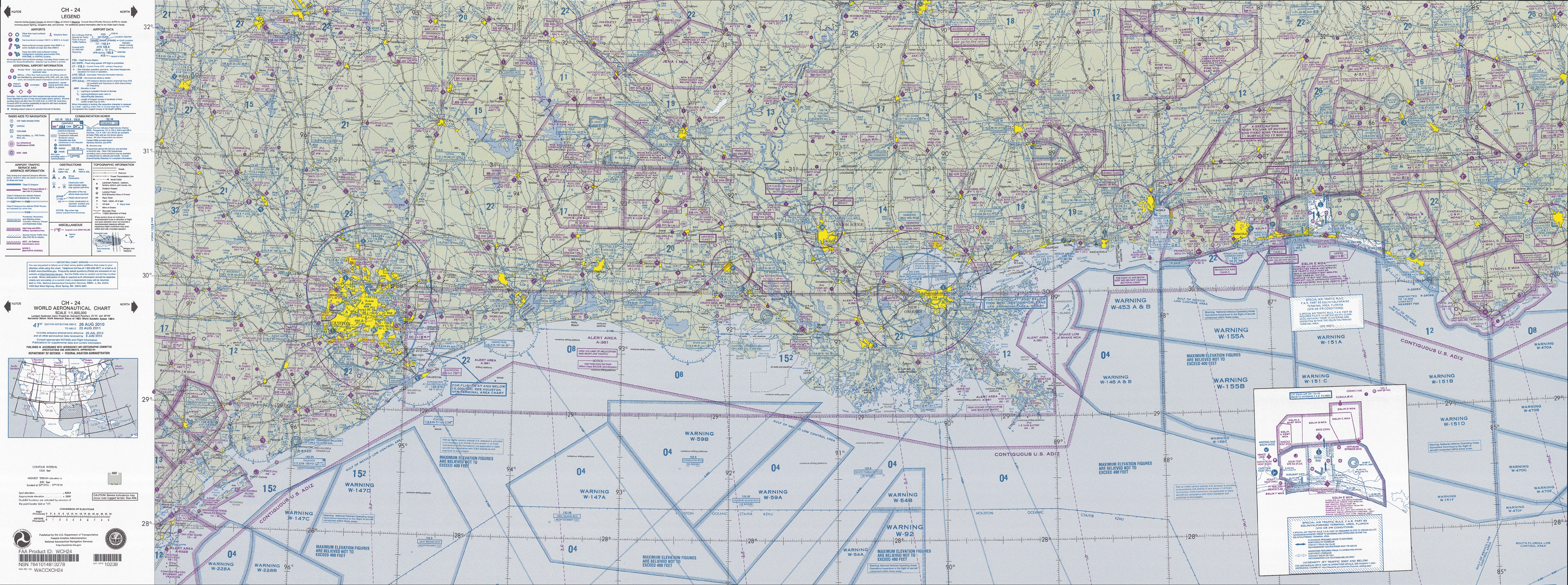
English: FAA World aeronautical chart CH 24 North, 41st edition (northern Gulf of Mexico). Note: This map is valid until ۱۵ اوت ۲۰۱۱, for navigational purposes be sure to get the newest edition at the official FAA website |
| تاریخ |
|
| منبع | CH-24_WAC_41_North.tif in CH-23_41.zip. Note: The ZIP-File will become unavailable when the map is updated, newer editions will be available here |
| پدیدآور | US Department of Transportation, Federal Aviation Administration, National Aeronautical Navigation Services |
| دیگر نسخهها |
This image or file is a work of a Federal Aviation Administration employee, taken or made as part of that person's official duties. As a work of the U.S. federal government, the image is in the public domain in the United States.
|
 |
تاریخچهٔ پرونده
روی تاریخ/زمانها کلیک کنید تا نسخهٔ مربوط به آن هنگام را ببینید.
| تاریخ/زمان | بندانگشتی | ابعاد | کاربر | توضیح | |
|---|---|---|---|---|---|
| کنونی | ۲۸ آوریل ۲۰۱۱، ساعت ۱۰:۲۱ | ۵٬۳۵۴ در ۲٬۰۰۰ (۶٫۰۲ مگابایت) | El Grafo | {{Information |Description={{en|1=FAA World aeronautical chart CH 24 North, 41st edition (northern Gulf of Mexico). <small>Note: This map is valid until {{date|2011|08|15}}, for navigational purposes be sure to get the new |
کاربرد پرونده
صفحهٔ زیر از این تصویر استفاده میکند:
کاربرد سراسری پرونده
ویکیهای دیگر زیر از این پرونده استفاده میکنند:
- کاربرد در de.wikipedia.org
- کاربرد در en.wikipedia.org
- کاربرد در es.wikipedia.org