
پرونده:CEM-44-La-Chine-la-Tartarie-Chinoise-et-le-Thibet-1734-Central-Asia-2574.jpg

اندازهٔ این پیشنمایش: ۸۰۰ × ۶۰۰ پیکسل. کیفیتهای دیگر: ۳۲۰ × ۲۴۰ پیکسل | ۶۴۰ × ۴۸۰ پیکسل | ۱٬۰۲۴ × ۷۶۸ پیکسل | ۱٬۲۸۰ × ۹۶۰ پیکسل | ۲٬۵۶۰ × ۱٬۹۲۰ پیکسل.
پروندهٔ اصلی (۲٬۵۶۰ × ۱٬۹۲۰ پیکسل، اندازهٔ پرونده: ۲٫۰۷ مگابایت، نوع MIME پرونده: image/jpeg)
این پرونده در ویکیانبار موجود است. محتویات صفحهٔ توصیف آن در زیر نمایش داده میشود. |
| توضیح |
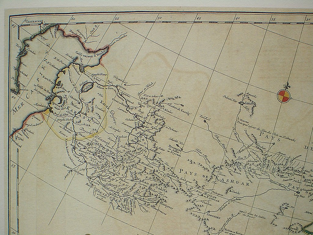
Français : Carte la plus generale et qui comprend la Chine, la Tartarie Chinoise, et le Thibet. Dressee sur les cartes particuliers des RR PP Jesuites, par le Sr. d'Anville..., qui ya joint le pays compris entre Kashgar et la mar Caspienne, tire des geographes et des historiens orientaux
English: A most general map, including China, Chinese Tartary, and Tibet, based on individual maps of the Jesuit fathers. The map gives 1734 as the year, but the modern HKUST publishers say 1737
English: Fragment: Central Asia area
"D’Anville’s maps of China were based on a survey of the Chinese empire that was ordered by the emperor in 1708 and carried out by the Chinese, but under the supervision of Jesuit priests resident in China. The detail about the interior of China was far superior to any previous Western map or atlas. D’Anville’s work remained a standard Western source for the geography of China and adjacent regions until well into the 19th century, when it finally was superseded by more accurate maps." — (World Digital Library) |
||||||||||||||||||||
| تاریخ | 1734, according to the map itself (although the modern publishers say 1737) | ||||||||||||||||||||
| منبع |
English: An antique map from the Special Collection "China in Maps" of the Hong Kong University of Science and Technology Library, reproduced by the HKUST Library in the book "China in European Maps", Hong Kong, 2003. ISBN 962-86403-9-9.
Русский: Старинная карта из специальной коллекции Библиотеки Гонконгского научно-технического университета. Опубликована этой библиотекой в книге "China in European Maps" (Китай на европейских картах), Гонконг, 2003. ISBN 962-86403-9-9, тиражом 1000 экз. См. также каталог выставки, Special Collection "China in Maps".
Plate 44 |
||||||||||||||||||||
| پدیدآور |
|
||||||||||||||||||||
| اجازهنامه (استفادهٔ مجدد از این پرونده) |
Author died more than 70 years ago - public domain | ||||||||||||||||||||
| دیگر نسخهها |
Entire map |
||||||||||||||||||||

|
این اثر در کشورهایی و مناطقی که مدت زمان حق تکثیر، عمر پدیدآورنده بعلاوه 100 سال یا کمتر بعد از مرگ او است، در مالکیت عمومی قرار دارد. | |
| این پرونده تحت قانون حق تکثیر محدودیت آزاد منتشر شده که شامل تمامی حقوق مربوطه و حقوق نزدیک به آن میشود. | |
تاریخچهٔ پرونده
روی تاریخ/زمانها کلیک کنید تا نسخهٔ مربوط به آن هنگام را ببینید.
| تاریخ/زمان | بندانگشتی | ابعاد | کاربر | توضیح | |
|---|---|---|---|---|---|
| کنونی | ۲۲ مارس ۲۰۰۹، ساعت ۱۳:۳۲ | | ۲٬۵۶۰ در ۱٬۹۲۰ (۲٫۰۷ مگابایت) | Vmenkov | {{Information |Description={{fr|Carte la plus generale et qui comprend la Chine, la Tartarie Chinoise, et le Thibet. Dressee sur les cartes particuliers des RR PP Jesuites, par le Sr. d'Anville..., qui ya joint le pays compris entre Kashgar et la mar Casp |
کاربرد پرونده
این پرونده در هیچ صفحهای به کار نرفته است.
کاربرد سراسری پرونده
ویکیهای دیگر زیر از این پرونده استفاده میکنند:
- کاربرد در azb.wikipedia.org
- کاربرد در bg.wikipedia.org
- کاربرد در bn.wikipedia.org
- کاربرد در da.wikipedia.org
- کاربرد در en.wikipedia.org
- کاربرد در eo.wikipedia.org
- کاربرد در es.wikipedia.org
- کاربرد در fr.wikipedia.org
- کاربرد در hu.wikipedia.org
- کاربرد در ko.wikipedia.org
- کاربرد در no.wikipedia.org
- کاربرد در pl.wikipedia.org
- کاربرد در sl.wikipedia.org
- کاربرد در zh.wikipedia.org