
پرونده:Australia Victoria Glenelg Shire location map.svg

حجم پیشنمایش PNG این SVG file:۴۲۱ × ۶۰۰ پیکسل کیفیتهای دیگر: ۱۶۸ × ۲۴۰ پیکسل | ۳۳۷ × ۴۸۰ پیکسل | ۵۳۹ × ۷۶۸ پیکسل | ۷۱۹ × ۱٬۰۲۴ پیکسل | ۱٬۴۳۸ × ۲٬۰۴۸ پیکسل | ۵۳۳ × ۷۵۹ پیکسل.
پروندهٔ اصلی (پروندهٔ اسویجی، با ابعاد ۵۳۳ × ۷۵۹ پیکسل، اندازهٔ پرونده: ۵۰۶ کیلوبایت)
این پرونده در ویکیانبار موجود است. محتویات صفحهٔ توصیف آن در زیر نمایش داده میشود. |
| توضیح |
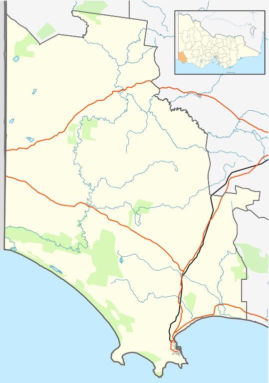
English: Blank map of w:Glenelg Shire, Victoria, Australia, with the following information shown:
Geographic limits:
|
||
| منبع | اثر شخصی + VicMap Lite | ||
| پدیدآور | Cassowary |

| برچسبها | این نگاره برچسپگذاری شدهاست: برچسپها را در ویکیانبار مشاهده کنید |
تاریخچهٔ پرونده
روی تاریخ/زمانها کلیک کنید تا نسخهٔ مربوط به آن هنگام را ببینید.
| تاریخ/زمان | بندانگشتی | ابعاد | کاربر | توضیح | |
|---|---|---|---|---|---|
| کنونی | ۱۷ فوریهٔ ۲۰۱۱، ساعت ۱۴:۴۲ | | ۵۳۳ در ۷۵۹ (۵۰۶ کیلوبایت) | Cassowary | {{Information |Description ={{en|1= Blank map of w:Glenelg Shire, Victoria, Australia, with the following information shown: * LGA boundaries * Coastline, lakes and rivers * Roads and railways * Urban areas * Parks Geographic limits: * North: 37.3 |
کاربرد پرونده
صفحهٔ زیر از این تصویر استفاده میکند:
کاربرد سراسری پرونده
ویکیهای دیگر زیر از این پرونده استفاده میکنند:
- کاربرد در ar.wikipedia.org
- کاربرد در ceb.wikipedia.org
- کاربرد در en.wikipedia.org
- Portland, Victoria
- Shire of Glenelg
- Heywood, Victoria
- Allestree, Victoria
- Nelson, Victoria
- Cape Bridgewater
- Casterton, Victoria
- Dartmoor, Victoria
- Merino, Victoria
- Template:Towns in Glenelg Shire
- Tyrendarra
- Henty, Victoria
- Narrawong
- Condah
- Digby, Victoria
- Sandford, Victoria
- Module:Location map/data/Australia Victoria Shire of Glenelg/doc
- Lawrence Rocks
- Tahara, Victoria
- Paschendale, Victoria
- Gorae West
- Heathmere
- Hotspur, Victoria
- Drumborg
- Module:Location map/data/Australia Victoria Shire of Glenelg
- Bahgallah
- Bolwarra, Victoria
- Breakaway Creek, Victoria
- Brimboal
- Carapook
- Cashmore, Victoria
- Chetwynd, Victoria
- User:Viatori/sandbox
- User:ThylacineHunter/LGA
- کاربرد در incubator.wikimedia.org
- کاربرد در kn.wikipedia.org
- کاربرد در pnb.wikipedia.org
- کاربرد در si.wikipedia.org
- کاربرد در tr.wikipedia.org
- کاربرد در ur.wikipedia.org
- کاربرد در uz.wikipedia.org
- کاربرد در vi.wikipedia.org
- کاربرد در war.wikipedia.org