
پرونده:Australia Victoria East Gippsland Shire location map.svg

حجم پیشنمایش PNG این SVG file:۵۳۳ × ۳۵۳ پیکسل کیفیتهای دیگر: ۳۲۰ × ۲۱۲ پیکسل | ۶۴۰ × ۴۲۴ پیکسل | ۱٬۰۲۴ × ۶۷۸ پیکسل | ۱٬۲۸۰ × ۸۴۸ پیکسل | ۲٬۵۶۰ × ۱٬۶۹۵ پیکسل.
پروندهٔ اصلی (پروندهٔ اسویجی، با ابعاد ۵۳۳ × ۳۵۳ پیکسل، اندازهٔ پرونده: ۸۹۳ کیلوبایت)
این پرونده در ویکیانبار موجود است. محتویات صفحهٔ توصیف آن در زیر نمایش داده میشود. |
| توضیح |
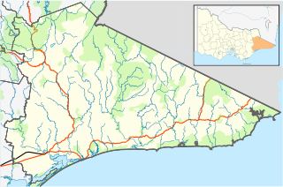
English: Blank map of w:East Gippsland Shire, Victoria, Australia, with the following information shown:
Geographic limits:
|
||
| منبع | اثر شخصی + VicMap Lite | ||
| پدیدآور | Cassowary |

تاریخچهٔ پرونده
روی تاریخ/زمانها کلیک کنید تا نسخهٔ مربوط به آن هنگام را ببینید.
| تاریخ/زمان | بندانگشتی | ابعاد | کاربر | توضیح | |
|---|---|---|---|---|---|
| کنونی | ۱۷ فوریهٔ ۲۰۱۱، ساعت ۱۲:۵۶ | | ۵۳۳ در ۳۵۳ (۸۹۳ کیلوبایت) | Cassowary | {{Information |Description ={{en|1=Blank map of w:East Gippsland Shire, Victoria, Australia, with the following information shown: * LGA boundaries * Coastline, lakes and rivers * Roads and railways * Urban areas * Parks Geographic limits: * North |
کاربرد پرونده
صفحهٔ زیر از این تصویر استفاده میکند:
کاربرد سراسری پرونده
ویکیهای دیگر زیر از این پرونده استفاده میکنند:
- کاربرد در ar.wikipedia.org
- کاربرد در ceb.wikipedia.org
- کاربرد در en.wikipedia.org
- Shire of East Gippsland
- Goongerah, Victoria
- Mallacoota, Victoria
- Bairnsdale
- Lakes Entrance, Victoria
- Paynesville, Victoria
- Raymond Island
- Orbost
- Gabo Island
- Swifts Creek
- Buchan, Victoria
- Cann River, Victoria
- Omeo
- Nowa Nowa, Victoria
- Ensay, Victoria
- Benambra, Victoria
- Bruthen, Victoria
- Metung
- Newmerella, Victoria
- Cassilis, Victoria
- Bemm River, Victoria
- Genoa, Victoria
- Rotamah Island
- Tullaberga Island
- Omeo & District Football League
- East Gippsland Football League
- Swan Reach, Victoria
- Marlo, Victoria
- Johnsonville, Victoria
- Nicholson, Victoria
- Fernbank, Victoria
- Template:Towns in East Gippsland Shire
- W Tree, Victoria
- Orbost railway station
- Cape Conran
- Lindenow, Victoria
- Anglers Rest, Victoria
- Module:Location map/data/Australia Victoria Shire of East Gippsland/doc
- Bonang Road
- Tambo Crossing, Victoria
- Eagle Point, Victoria
- Suggan Buggan, Victoria
- Eastwood, Victoria
- Lake Tyers Mission
- Lucknow, Victoria
- The Skerries (Victoria)
- Wy Yung, Victoria
- Module:Location map/data/Australia Victoria Shire of East Gippsland
نمایش استفادههای سراسری از این پرونده.