
پرونده:Australia Victoria Colac Otway Shire location map.svg

حجم پیشنمایش PNG این SVG file:۴۱۹ × ۵۹۹ پیکسل کیفیتهای دیگر: ۱۶۸ × ۲۴۰ پیکسل | ۳۳۶ × ۴۸۰ پیکسل | ۵۳۷ × ۷۶۸ پیکسل | ۷۱۷ × ۱٬۰۲۴ پیکسل | ۱٬۴۳۳ × ۲٬۰۴۸ پیکسل | ۵۳۴ × ۷۶۳ پیکسل.
پروندهٔ اصلی (پروندهٔ اسویجی، با ابعاد ۵۳۴ × ۷۶۳ پیکسل، اندازهٔ پرونده: ۶۵۵ کیلوبایت)
این پرونده در ویکیانبار موجود است. محتویات صفحهٔ توصیف آن در زیر نمایش داده میشود. |
| توضیح |
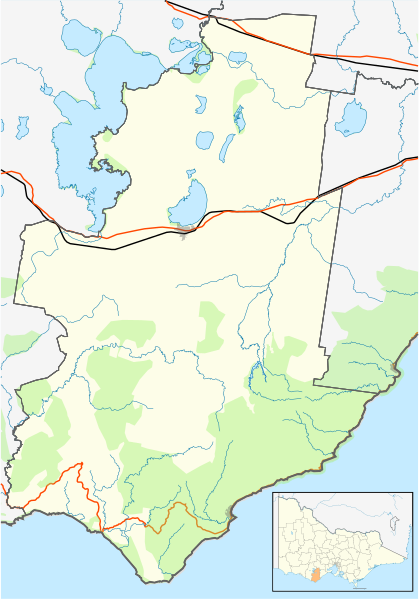
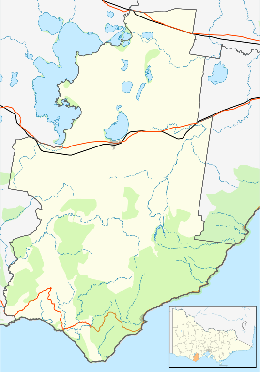
English: Blank map of w:Colac Otway Shire, Victoria, Australia, with the following information shown:
Geographic limits:
|
||
| منبع | اثر شخصی | ||
| پدیدآور | Cassowary |

تاریخچهٔ پرونده
روی تاریخ/زمانها کلیک کنید تا نسخهٔ مربوط به آن هنگام را ببینید.
| تاریخ/زمان | بندانگشتی | ابعاد | کاربر | توضیح | |
|---|---|---|---|---|---|
| کنونی | ۱۷ فوریهٔ ۲۰۱۱، ساعت ۱۲:۲۹ | | ۵۳۴ در ۷۶۳ (۶۵۵ کیلوبایت) | Cassowary | {{Information |Description ={{en|1=Blank map of w:Colac Otway Shire, Victoria, Australia, with the following information shown: * LGA boundaries * Coastline, lakes and rivers * Roads and railways * Urban areas * Parks Geographic limits: * North: |
کاربرد پرونده
صفحهٔ زیر از این تصویر استفاده میکند:
کاربرد سراسری پرونده
ویکیهای دیگر زیر از این پرونده استفاده میکنند:
- کاربرد در ar.wikipedia.org
- کاربرد در ceb.wikipedia.org
- کاربرد در en.wikipedia.org
- Colac, Victoria
- Shire of Colac Otway
- Apollo Bay
- Winchelsea, Victoria
- Kennett River, Victoria
- Wye River, Victoria
- Alvie, Victoria
- Forrest, Victoria
- Johanna, Victoria
- Warrion, Victoria
- Cressy, Victoria
- Birregurra
- Cape Otway
- Lavers Hill
- Beeac
- Beech Forest, Victoria
- Template:Towns in Colac Otway Shire
- Simpson, Victoria
- User:Gerixau/temp2
- Swan Marsh
- Module:Location map/data/Australia Victoria Colac Otway Shire/doc
- Barwon Downs
- Gellibrand, Victoria
- Ombersley, Victoria
- Pennyroyal, Victoria
- Separation Creek, Victoria
- Mount Sabine, Victoria
- Grey River, Victoria
- Wongarra, Victoria
- Sugarloaf, Victoria
- Petticoat Creek, Victoria
- Balintore, Victoria
- Pirron Yallock, Victoria
- Ferguson, Victoria
- Irrewillipe
- Larpent, Victoria
- Skenes Creek North, Victoria
- Module:Location map/data/Australia Victoria Colac Otway Shire
- Skenes Creek, Victoria
- Aire Valley, Victoria
- Tanybryn, Victoria
- Marengo, Victoria
- User:Viatori/sandbox
- Barongarook, Victoria
- User:ThylacineHunter/LGA
- Cororooke, Victoria
- Irrewarra, Victoria
- Barongarook West, Victoria
نمایش استفادههای سراسری از این پرونده.