هامونتن، نیوجرسی
(تغییرمسیر از هامونتن)
Hammonton, New Jersey | |
|---|---|
| لقب(ها): "Blueberry Capital of the World"[۱] | |
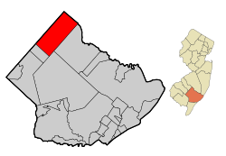
 Map of Hammonton in Atlantic County | |
 Census Bureau map of Hammonton, New Jersey | |
| مختصات: ۳۹°۳۹′۳۹″شمالی ۷۴°۴۶′۰۱″غربی / ۳۹٫۶۶۰۷۸°شمالی ۷۴٫۷۶۷۰۲۱°غربی | |
| کشور | United States |
| ایالات آمریکا | نیوجرسی |
| County | Atlantic |
| Incorporated | March 5, 1866 |
| مدیریت | |
| • نوع | Town |
| • شهردار | Stephen DiDonato (term ends December 31, 2013)[۲] |
| • Clerk | April Boyer Maimone[۳] |
| مساحت | |
| • کل | ۴۱٫۴۱۹ مایل مربع (۱۰۷٫۲۷۴ کیلومتر مربع) |
| • خشکی | ۴۰٫۸۸۷ مایل مربع (۱۰۵٫۸۹۷ کیلومتر مربع) |
| • آب | ۰٫۵۳۲ مایل مربع (۱٫۳۷۷ کیلومتر مربع) 1.28% |
| رتبه مساحت | 50th of 566 in state 7th of 23 in county[۵] |
| بلندی | ۹۵ پا (۲۹ متر) |
| جمعیت | |
| • کل | ۱۴٬۷۹۱ |
| • رتبه | 169th of 566 in state 6th of 23 in county[۱۰] |
| • تراکم | ۳۶۱٫۸/مایل مربع (۱۳۹٫۷/کیلومتر مربع) |
| • رتبه تراکم | 464th of 566 in state 15th of 23 in county[۱۰] |
| منطقه زمانی | یوتیسی -۵ (EST) |
| • تابستانی (DST) | یوتیسی -4 (Eastern (EDT)) |
| زیپکد | 08037[۱۱] |
| پیششماره(های) تلفن | 609 |
| FIPS code | 3400129430[۱۲][۵][۱۳] |
| GNIS feature ID | 0885242[۱۴][۵] |
| وبگاه | |
هامونتن (به انگلیسی: Hammonton) شهری در ایالت نیوجرسی کشور ایالات متحده آمریکا است که جمعیت آن در سرشماری سال ۲۰۱۰ میلادی، ۱۴٬۷۹۱ نفر بودهاست.[۱۵]
جستارهای وابسته[ویرایش]
منابع[ویرایش]
- ↑ Urgo, Jacqueline L. "Blueberries get their due", The Philadelphia Inquirer, January 25, 2004. Accessed May 19, 2008. "In this Atlantic County farming community, where crops are king and ancestral connections to the land run deep, they didn't need the state to tell them the blueberry is special. After all, almost everyone in this town of 12,600 - already dubbed the "Blueberry Capital of the World" - seems to have at least some connection to the berry."
- ↑ 2012 New Jersey Mayors Directory, New Jersey Department of Community Affairs, dated August 9, 2012. Accessed October 22, 2012.
- ↑ Municipal Clerks's Office بایگانیشده در ۴ ژوئن ۲۰۱۲ توسط Wayback Machine, Town of Hammonton. Accessed June 25, 2012.
- ↑ 2012 New Jersey Legislative District Data Book, دانشگاه راتگرز Edward J. Bloustein School of Planning and Public Policy, March 2013, p. 49.
- ↑ ۵٫۰ ۵٫۱ ۵٫۲ ۵٫۳ Gazetteer of New Jersey Places بایگانیشده در ۵ دسامبر ۲۰۱۲ توسط Archive.today, اداره آمار آمریکا. Accessed October 21, 2012.
- ↑ سامانه اطلاعات نامهای جغرافیایی ایالات متحده آمریکا: Town of Hammonton, Geographic Names Information System, accessed January 4, 2008.
- ↑ DP-1 - Profile of General Population and Housing Characteristics: 2010 Demographic Profile Data for Hammonton town, New Jersey, اداره آمار آمریکا. Accessed May 15, 2012.
- ↑ Municipalities Grouped by 2011-2020 Legislative Districts بایگانیشده در ۱۹ ژوئیه ۲۰۱۱ توسط Wayback Machine, New Jersey Department of State, p. 4. Accessed January 6, 2013.
- ↑ Profile of General Demographic Characteristics: 2010 for Hammonton town بایگانیشده در ۱۵ اوت ۲۰۱۴ توسط Wayback Machine, New Jersey Department of Labor and Workforce Development. Accessed May 15, 2012.
- ↑ ۱۰٫۰ ۱۰٫۱ GCT-PH1 Population, Housing Units, Area, and Density: 2010 - State -- County Subdivision from the 2010 Census Summary File 1 for New Jersey, اداره آمار آمریکا. Accessed October 22, 2012.
- ↑ Look Up a ZIP Code, خدمات پستی ایالات متحده آمریکا. Accessed September 3, 2011.
- ↑ "American FactFinder". اداره آمار آمریکا. Retrieved 2008-01-31.
- ↑ A Cure for the Common Codes: New Jersey بایگانیشده در ۲۷ مه ۲۰۱۲ توسط Archive.today, Missouri Census Data Center. Accessed May 15, 2012.
- ↑ "US Board on Geographic Names". سازمان نقشهبرداریهای زمینشناسی آمریکا. 2007-10-25. Retrieved 2008-01-31.
- ↑ "New Jersey" (به انگلیسی). world-gazetteer. Archived from the original on 23 April 2013. Retrieved 10 Jan 2013.

