
پرونده:Wright Brothers Memorial-27527-1.JPG

اندازهٔ این پیشنمایش: ۶۰۰ × ۶۰۰ پیکسل. کیفیتهای دیگر: ۲۴۰ × ۲۴۰ پیکسل | ۴۸۰ × ۴۸۰ پیکسل | ۷۶۸ × ۷۶۸ پیکسل | ۱٬۰۲۴ × ۱٬۰۲۴ پیکسل | ۱٬۶۰۰ × ۱٬۶۰۰ پیکسل.
پروندهٔ اصلی (۱٬۶۰۰ × ۱٬۶۰۰ پیکسل، اندازهٔ پرونده: ۵۴۵ کیلوبایت، نوع MIME پرونده: image/jpeg)
این پرونده در ویکیانبار موجود است. محتویات صفحهٔ توصیف آن در زیر نمایش داده میشود. |
خلاصه
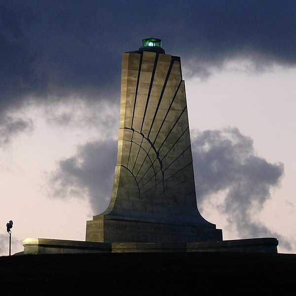
| توضیح |
Standing sixty feet (18.3 meters) tall and perched atop a ninety foot (27.4 meters) stabilized sand dune known as Kill Devil Hill, this monument towers over Wright Brothers National Memorial Park in Kill Devil Hills, NC. The park commemorates and preserves the site where the Wright brothers launched the world's first successful sustained, powered flights in a heavier-than-air machine. The inscription that wraps around the base of the monument states "In commemoration of the conquest of the air by the brothers Wilbur and Orville Wright. Conceived by genius, achieved by dauntless resolution and unconquerable faith." Photo taken with a Panasonic Lumix DMC-FZ50 in Dare County, NC, USA. |
| تاریخ | ۱۹ اکتبر ۲۰۰۸, ۰۶:۵۶ −۰۴:۰۰ |
| منبع |
KenThomas.us (personal website of photographer) |
| پدیدآور | Ken Thomas |
| اجازهنامه (استفادهٔ مجدد از این پرونده) |
This image is released to the public domain, and therefore no permission or credit is required. Comments and/or feedback however, are always welcome. See my user page for contact info. |
| دیگر نسخهها |
|

اجازهنامه
| من، دارنده حق تکثیر این اثر، این اثر را به مالکیت عمومی منتشر میکنم. این قابل اجرا در تمام نقاط جهان است. در برخی از کشورها ممکن است به صورت قانونی این امکانپذیر نباشد؛ اگر چنین است: من اجازهٔ استفاده از این اثر را برای هر مقصودی، بدون هیچگونه شرایطی میدهم، تا وقتی که این شرایط توسط قانون مستلزم نشده باشد. |
| مختصات دوربین | | محل قرارگیری این نگاره و سایر نگارهها در: نقشهٔ شهری باز |
|---|
تاریخچهٔ پرونده
روی تاریخ/زمانها کلیک کنید تا نسخهٔ مربوط به آن هنگام را ببینید.
| تاریخ/زمان | بندانگشتی | ابعاد | کاربر | توضیح | |
|---|---|---|---|---|---|
| کنونی | ۲۰ اکتبر ۲۰۰۸، ساعت ۱۵:۱۸ | | ۱٬۶۰۰ در ۱٬۶۰۰ (۵۴۵ کیلوبایت) | Ken Thomas | {{Information |Description=Standing sixty feet (18.3 meters) tall and perched atop a ninety foot (27.4 meters) stabilized sand dune known as Kill Devil Hill, this monument towers o |
کاربرد پرونده
صفحهٔ زیر از این تصویر استفاده میکند:
کاربرد سراسری پرونده
ویکیهای دیگر زیر از این پرونده استفاده میکنند:
- کاربرد در ast.wikipedia.org
- کاربرد در ca.wikipedia.org
- کاربرد در ceb.wikipedia.org
- کاربرد در cs.wikipedia.org
- کاربرد در de.wikipedia.org
- کاربرد در en.wikipedia.org
- کاربرد در en.wikivoyage.org
- کاربرد در eo.wikipedia.org
- کاربرد در es.wikipedia.org
- کاربرد در fi.wikipedia.org
- کاربرد در fr.wikipedia.org
- کاربرد در hr.wikipedia.org
- کاربرد در it.wikipedia.org
- کاربرد در ja.wikipedia.org
- کاربرد در nn.wikipedia.org
- کاربرد در no.wikipedia.org
- کاربرد در pnb.wikipedia.org
- کاربرد در pt.wikipedia.org
- کاربرد در ru.wikipedia.org
- کاربرد در www.wikidata.org
- کاربرد در zh.wikipedia.org