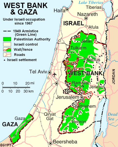
پرونده:West Bank & Gaza Map 2007 (Settlements).png

اندازهٔ این پیشنمایش: ۴۸۲ × ۵۹۹ پیکسل. کیفیتهای دیگر: ۱۹۳ × ۲۴۰ پیکسل | ۳۸۶ × ۴۸۰ پیکسل | ۷۸۰ × ۹۷۰ پیکسل.
پروندهٔ اصلی (۷۸۰ × ۹۷۰ پیکسل، اندازهٔ پرونده: ۸۶ کیلوبایت، نوع MIME پرونده: image/png)
تاریخچهٔ پرونده
روی تاریخ/زمانها کلیک کنید تا نسخهٔ مربوط به آن هنگام را ببینید.
| تاریخ/زمان | بندانگشتی | ابعاد | کاربر | توضیح | |
|---|---|---|---|---|---|
| کنونی | ۲۹ اکتبر ۲۰۱۳، ساعت ۲۲:۵۵ |  | ۷۸۰ در ۹۷۰ (۸۶ کیلوبایت) | Scott | Correct capitalization in legend. |
| ۲۹ اکتبر ۲۰۱۳، ساعت ۲۲:۵۴ |  | ۷۸۰ در ۹۷۰ (۸۶ کیلوبایت) | Scott | Correct capitalization in legend. | |
| ۱۲ ژانویهٔ ۲۰۰۹، ساعت ۰۶:۲۱ |  | ۷۸۰ در ۹۷۰ (۱۰۵ کیلوبایت) | HowardMorland | Replace .gif file with identical .png file <!--{{ImageUpload|basic}}--> |
کاربرد پرونده
صفحههای زیر از این تصویر استفاده میکنند:
کاربرد سراسری پرونده
ویکیهای دیگر زیر از این پرونده استفاده میکنند:
- کاربرد در am.wikipedia.org
- کاربرد در ar.wikipedia.org
- کاربرد در ast.wikipedia.org
- کاربرد در azb.wikipedia.org
- کاربرد در bg.wikipedia.org
- کاربرد در ca.wikipedia.org
- کاربرد در ckb.wikipedia.org
- کاربرد در cs.wikipedia.org
- کاربرد در cy.wikipedia.org
- کاربرد در da.wikipedia.org
- کاربرد در de.wikipedia.org
- کاربرد در de.wikinews.org
- کاربرد در de.wikivoyage.org
- کاربرد در en.wikipedia.org
- Talk:List of ongoing armed conflicts
- User:Timeshifter/Userboxes
- User:Gimmetrow/test
- User:Gimmetrow/test2
- User:Keizers
- Talk:Jerusalem/Archive 15
- Talk:Palestinian National Authority/Archive 2
- Wikipedia:Top 25 Report/July 13 to 19, 2014
- Wikipedia:Top 25 Report/July 20 to 26, 2014
- Wikipedia:Top 25 Report/July 27 to August 2, 2014
- Talk:State of Palestine/Archive 12
- User:Timeshifter/Userboxes/Palestine: Peace Not Apartheid. By Jimmy Carter
- User:Dare2Leap/info
- User:Timeshifter/Archive 2
- Wikipedia talk:WikiProject Israel Palestine Collaboration/Archive 9
- کاربرد در en.wikinews.org
- کاربرد در eo.wikipedia.org
- کاربرد در es.wikipedia.org
- کاربرد در eu.wikipedia.org
- کاربرد در fi.wikipedia.org
- کاربرد در fo.wikipedia.org
- کاربرد در fr.wikipedia.org
نمایش استفادههای سراسری از این پرونده.
