
پرونده:USACE G V Montgomery Lock and Dam.jpg

اندازهٔ این پیشنمایش: ۸۰۰ × ۵۶۰ پیکسل. کیفیتهای دیگر: ۳۲۰ × ۲۲۴ پیکسل | ۶۴۰ × ۴۴۸ پیکسل | ۱٬۰۲۴ × ۷۱۷ پیکسل | ۱٬۲۸۰ × ۸۹۶ پیکسل | ۱٬۵۰۰ × ۱٬۰۵۰ پیکسل.
پروندهٔ اصلی (۱٬۵۰۰ × ۱٬۰۵۰ پیکسل، اندازهٔ پرونده: ۴۳۸ کیلوبایت، نوع MIME پرونده: image/jpeg)
این پرونده در ویکیانبار موجود است. محتویات صفحهٔ توصیف آن در زیر نمایش داده میشود. |
| توضیح |
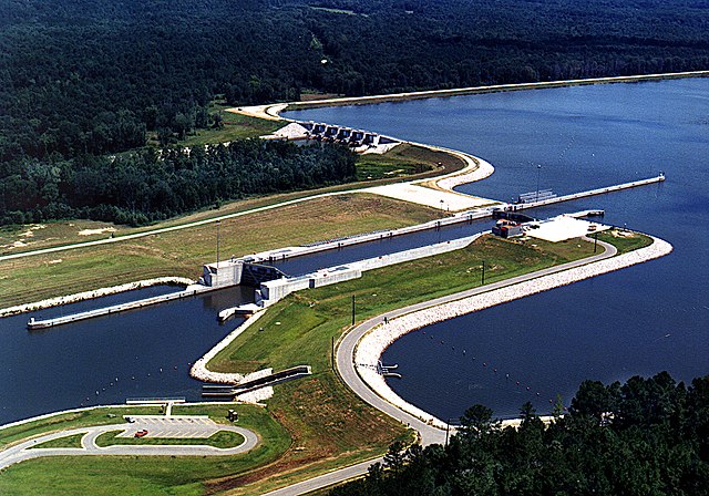
English: Aerial view of the G. V. Montgomery Lock and Dam on the Tennessee-Tombigbee Waterway. The lock is located in Itawamba County, Mississippi, USA. At this point the border between Itawamba County and Prentiss County crosses the waterway, and the dam (visible at top) is actually located in Prentiss County. The lock and dam are part of the Tennessee-Tombigbee project, constructed by the U.S. Army Corps of Engineers for barge navigation between the Tennessee River and the Gulf of Mexico. View is to the north.
Coordinates: 34°27′47.06″N 88°21′53.5″W / 34.4630722°N 88.364861°W |
|||
| مکان | Itawamba County, Mississippi, USA | |||
| تاریخ | (Caveat: Dates provided by U.S. Army Corps of Engineers Digital Visual Library are not reliable and may be wrong.) | |||
| منبع |
U.S. Army Corps of Engineers Digital Visual Library Image page Image description page Digital Visual Library home page |
|||
| پدیدآور | Adrien Lamarre, U.S. Army Corps of Engineers | |||
| اجازهنامه (استفادهٔ مجدد از این پرونده) |
|
تاریخچهٔ پرونده
روی تاریخ/زمانها کلیک کنید تا نسخهٔ مربوط به آن هنگام را ببینید.
| تاریخ/زمان | بندانگشتی | ابعاد | کاربر | توضیح | |
|---|---|---|---|---|---|
| کنونی | ۲۹ آوریل ۲۰۰۷، ساعت ۱۷:۴۴ | | ۱٬۵۰۰ در ۱٬۰۵۰ (۴۳۸ کیلوبایت) | DanMS | {{Information | Description = {{en|Aerial view of the G. V. Montgomery Lock and Dam on the Tennessee-Tombigbee Waterway. The lock is located in Itawamba County, Mississippi, USA. At this point the border between Itawamba County and Prentiss County cros |
کاربرد پرونده
صفحهٔ زیر از این تصویر استفاده میکند:
کاربرد سراسری پرونده
ویکیهای دیگر زیر از این پرونده استفاده میکنند:
- کاربرد در en.wikipedia.org
- کاربرد در es.wikipedia.org
- کاربرد در www.wikidata.org