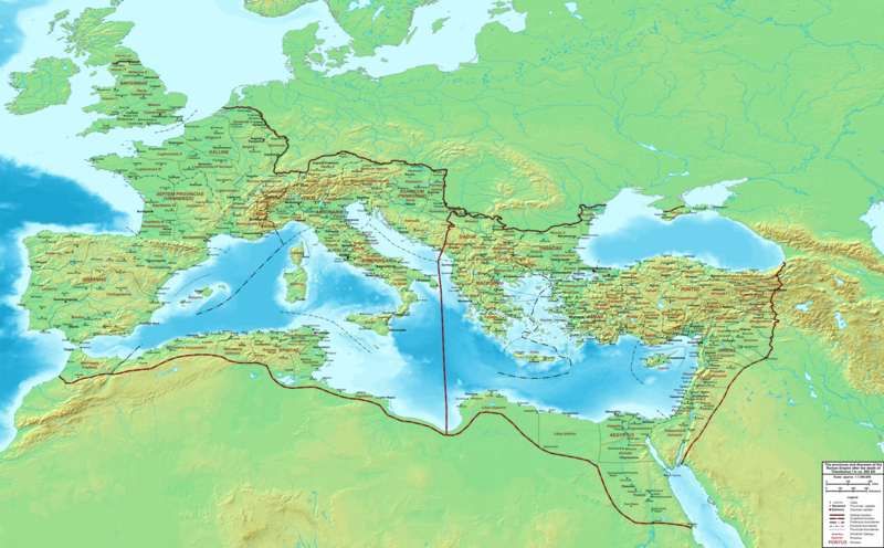
پرونده:The Roman Empire ca 400 AD.png
Appearance

اندازهٔ این پیشنمایش: ۸۰۰ × ۴۹۶ پیکسل. کیفیتهای دیگر: ۳۲۰ × ۱۹۸ پیکسل | ۶۴۰ × ۳۹۷ پیکسل | ۱٬۰۲۴ × ۶۳۵ پیکسل | ۱٬۲۸۰ × ۷۹۳ پیکسل | ۲٬۵۶۰ × ۱٬۵۸۷ پیکسل | ۴٬۳۳۹ × ۲٬۶۸۹ پیکسل.
پروندهٔ اصلی (۴٬۳۳۹ × ۲٬۶۸۹ پیکسل، اندازهٔ پرونده: ۱۲٫۸ مگابایت، نوع MIME پرونده: image/png)
تاریخچهٔ پرونده
روی تاریخ/زمانها کلیک کنید تا نسخهٔ مربوط به آن هنگام را ببینید.
| تاریخ/زمان | بندانگشتی | ابعاد | کاربر | توضیح | |
|---|---|---|---|---|---|
| کنونی | ۱۹ فوریهٔ ۲۰۱۵، ساعت ۲۲:۲۷ |  | ۴٬۳۳۹ در ۲٬۶۸۹ (۱۲٫۸ مگابایت) | Cplakidas | added potential location of Valentia beyond Hadrian's Wall, removed provincial boundaries in Britannia as too tentative |
| ۲۱ ژوئیهٔ ۲۰۱۱، ساعت ۱۳:۰۳ |  | ۴٬۳۳۹ در ۲٬۶۸۹ (۱۰٫۹ مگابایت) | Cplakidas | fixed Persian border, differentiated between Eastern and Western empire, different borders for praet. prefectures | |
| ۲۱ مارس ۲۰۰۹، ساعت ۰۲:۳۷ |  | ۴٬۴۷۵ در ۲٬۶۰۰ (۹٫۹۹ مگابایت) | Cplakidas | minor corrections | |
| ۲۹ مهٔ ۲۰۰۸، ساعت ۱۲:۳۰ |  | ۳٬۸۰۰ در ۲٬۳۷۰ (۸٫۱ مگابایت) | Cplakidas | ||
| ۲۹ مهٔ ۲۰۰۸، ساعت ۱۲:۱۷ |  | ۴٬۵۶۰ در ۲٬۸۵۰ (۱۱٫۲۲ مگابایت) | Cplakidas | clearer version & addition of the Armenian satrapies | |
| ۳۰ دسامبر ۲۰۰۷، ساعت ۰۲:۰۲ |  | ۳٬۳۸۰ در ۲٬۱۲۰ (۵٫۹۶ مگابایت) | Cplakidas | added names of dioceses, legend box, various minor adjustments | |
| ۱۳ دسامبر ۲۰۰۷، ساعت ۱۴:۲۷ |  | ۳٬۵۵۰ در ۲٬۲۰۰ (۶٫۶۵ مگابایت) | Cplakidas | new improved version made with Inkscape, slight corrections in borders, added several cities in Africa & Spain | |
| ۱۲ نوامبر ۲۰۰۷، ساعت ۱۹:۲۷ |  | ۳٬۵۵۰ در ۲٬۲۰۰ (۴٫۷۵ مگابایت) | Cplakidas | minor corrections in southern Gaul | |
| ۵ نوامبر ۲۰۰۷، ساعت ۱۲:۵۸ |  | ۳٬۵۵۰ در ۲٬۲۰۰ (۴٫۷۵ مگابایت) | Cplakidas | New version, with some corrections & additions | |
| ۳۱ اکتبر ۲۰۰۷، ساعت ۱۶:۵۵ |  | ۳٬۴۳۶ در ۲٬۱۴۲ (۴٫۵ مگابایت) | Cplakidas | {{Information |Description=Map of the Roman Empire ca. 400 AD, showing the administrative division into dioceses and provinces, as well as the major cities. The demarcation between Eastern and Western Empires is noted in red. |Source=Base map found at |
کاربرد پرونده
این پرونده در هیچ صفحهای به کار نرفته است.
کاربرد سراسری پرونده
ویکیهای دیگر زیر از این پرونده استفاده میکنند:
- کاربرد در af.wikipedia.org
- کاربرد در ar.wikipedia.org
- کاربرد در ary.wikipedia.org
- کاربرد در ast.wikipedia.org
- کاربرد در bg.wikipedia.org
- کاربرد در bn.wikipedia.org
- کاربرد در ca.wikipedia.org
- کاربرد در ceb.wikipedia.org
- کاربرد در cs.wikipedia.org
- کاربرد در de.wikipedia.org
- کاربرد در el.wikipedia.org
- کاربرد در en.wikipedia.org
- کاربرد در eo.wikipedia.org
- کاربرد در es.wikipedia.org
- کاربرد در et.wikipedia.org
- کاربرد در fr.wikipedia.org
- کاربرد در he.wikipedia.org
- کاربرد در hi.wikipedia.org
- کاربرد در hr.wikipedia.org
- کاربرد در hu.wikipedia.org
- کاربرد در id.wikipedia.org
- کاربرد در it.wikipedia.org
- کاربرد در ko.wikipedia.org
- کاربرد در la.wikipedia.org
نمایش استفادههای سراسری از این پرونده.


