پرونده:Nova totius Terrarum Orbis geographica ac hydrographica tabula (Hendrik Hondius) balanced.jpg

Page contents not supported in other languages.
از ویکی‌پدیا، دانشنامهٔ آزاد

پروندهٔ اصلی(۵٬۲۴۸ × ۳٬۶۸۸ پیکسل، اندازهٔ پرونده: ۵٫۳ مگابایت، نوع MIME پرونده: image/jpeg)

خلاصه

Jodocus Hondius II: Nova totius terrarum orbis geographica ac hydrographica tabula  wikidata:Q120597485 reasonator:Q120597485
هنرمند
Jodocus Hondius II  (1593–1629)  wikidata:Q21016928
 
توضیحات قلم‌زن، نقشه‌نگار، ویراستار، instrument maker، medical instrument maker و printmaker هلندی
تاریخ تولد/درگذشت ‏نوامبر ۱۵۹۳‏ ویرایش در ویکی‌داده ‏اوت ۱۶۲۹‏ ویرایش در ویکی‌داده
محل تولد/مرگ آمستردام آمستردام
محل کار
آمستردام (۱۶۱۲–۱۶۳۳) ویرایش در ویکی‌داده
کنترل از طریق مرجع
creator QS:P170,Q21016928
 ویرایش در ویکی‌داده
image of artwork listed in title parameter on this page
پدیدآور
Henricus Hondius II  (1597–1651)  wikidata:Q983261
 
نام‌های دیگر
Hendrick Hondius, Henricus Hondius II, Hendrik Hondius the Younger
توضیحات نقشه‌نگار، ناشر، printmaker، نقاش و کتاب فروش اسپانیایی-هلندی
تاریخ تولد/درگذشت ۱۵۹۷ ویرایش در ویکی‌داده ‏۱۶ اوت ۱۶۵۱‏ ویرایش در ویکی‌داده
محل تولد/مرگ آمستردام آمستردام
دوره کار ۱۶۱۲ ویرایش در ویکی‌داده–۱۶۴۴ ویرایش در ویکی‌داده
محل کار
کنترل از طریق مرجع
creator QS:P170,Q983261
عنوان
لاتین:
Nova Totius Terrarum Orbis Geographica ac Hydrographica Tabula

New Geographic and Hydrographic Map of the Whole World
title QS:P1476,la:"Nova Totius Terrarum Orbis Geographica ac Hydrographica Tabula"
label QS:Lla,"Nova Totius Terrarum Orbis Geographica ac Hydrographica Tabula"
label QS:Len,"New Geographic and Hydrographic Map of the Whole World"
ناشر
نوع شیء نقشه جهان / antique map / manuscript map / double hemisphere world map / نقشه‌های کهن ویرایش در ویکی‌داده
ژانر نقشه ویرایش در ویکی‌داده
توضیح

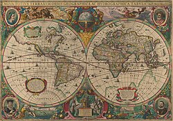
This is an image of Nova totius Terrarum Orbis geographica ac hydrographica tabula, a map of the world created by Hendrik Hondius in 1630, and published the following year in the atlas Atlantis Maioris Appendix.

Among its claims to notability is the fact that it was the first dated map published in an atlas, and therefore the first widely available map, to show any part of Australia, the only previous map to do so being Hessel Gerritsz' 1627 Caert van't Landt van d'Eendracht ("Chart of the Land of Eendracht"), which was not widely distributed.

The Australian coastline shown is part of the west coast of Cape York Peninsula, discovered by Jan Carstensz in 1623. Curiously, the map does not show the west coast features shown in Gerritsz' Caert.
زبان زبان لاتین ویرایش در ویکی‌داده
تاریخ The original map was executed in 1630, and published in 1631.
تاریخ انتشار ۱۶۳۰ ویرایش در ویکی‌داده
ابعاد بلندی: ۵۴٫۰ سانتی‌متر ویرایش در ویکی‌داده؛ عرض: ۳۸٫۰ سانتی‌متر ویرایش در ویکی‌داده
dimensions QS:P2048,+54U174728
dimensions QS:P2049,+38U174728
institution QS:P195,Q111677119
محل انتشار ناشناخته ویرایش در ویکی‌داده
منبع/عکاس This is a scan of the copy belonging to the State Library of New South Wales. Access to it is available at http://image.sl.nsw.gov.au/cgi-bin/ebindshow.pl?doc=heritage/a1439;seq=13. The graphical user interface provided does not support downloading the full image at full resolution, but the back end can be cajoled to do so by manually editing the CGI arguments in the url, to http://image.sl.nsw.gov.au/cgi-bin/mrsid/image_jpeg.pl?client=heritage/a1439&image=a128994.sid&x=2624&y=1844&level=0&width=5248&height=3688.
دیگر نسخه‌ها This is a colour-balanced version; the original version is at Image:Nova totius Terrarum Orbis geographica ac hydrographica tabula (Hendrik Hondius).jpg

اجازه‌نامه

این اثر هنری دوبعدی که در این نگاره دیده می‌شود بخاطر تاریخ درگذشت پدیدآورنده آن یا تاریخ انتشارش هم‌اکنون در سراسر جهان در مالکیت عمومی قرار دارد و استفاده از آن آزاد است.
Public domain

این اثر در کشورهایی و مناطقی که مدت زمان حق تکثیر، عمر پدیدآورنده بعلاوه 100 سال یا کمتر بعد از مرگ او است، در مالکیت عمومی قرار دارد.


You must also include a United States public domain tag to indicate why this work is in the public domain in the United States.
بنابراین تکثیر آن در ایالات متحده آمریکا، آلمان و بسیاری کشورهای دیگر آزاد است.

عنوان

شرحی یک‌خطی از محتوای این فایل اضافه کنید
Early Double Hemisphere World Map.

آیتم‌هایی که در این پرونده نمایش داده شده‌اند

توصیف‌ها

تاریخچهٔ پرونده

روی تاریخ/زمان‌ها کلیک کنید تا نسخهٔ مربوط به آن هنگام را ببینید.

تاریخ/زمانبندانگشتیابعادکاربرتوضیح
کنونی‏۶ فوریهٔ ۲۰۰۸، ساعت ۲۳:۰۹تصویر بندانگشتی از نسخهٔ مورخ ‏۶ فوریهٔ ۲۰۰۸، ساعت ۲۳:۰۹۵٬۲۴۸ در ۳٬۶۸۸ (۵٫۳ مگابایت)Hesperian{{Information |Description=This is an image of ''Nova totius Terrarum Orbis geographica ac hydrographica tabula'', a map of the world created by Hendrik Hondius in 1630, and published the following year in the atlas ''Atlantis Maioris Appendix

صفحهٔ زیر از این تصویر استفاده می‌کند:

کاربرد سراسری پرونده

ویکی‌های دیگر زیر از این پرونده استفاده می‌کنند:

نمایش استفاده‌های سراسری از این پرونده.

فراداده