
پرونده:NASA RabaulVolcano PIA01767.jpg

پروندهٔ اصلی (۸۵۳ × ۹۹۳ پیکسل، اندازهٔ پرونده: ۸۵۵ کیلوبایت، نوع MIME پرونده: image/jpeg)
این پرونده در ویکیانبار موجود است. محتویات صفحهٔ توصیف آن در زیر نمایش داده میشود. |
خلاصه
| توضیح |
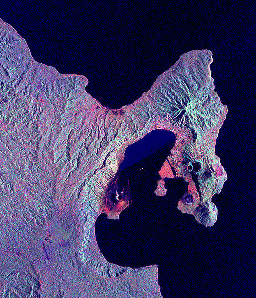
English: Space Radar Image of Rabaul Volcano, New Guinea
Credit NASA JPL http://visibleearth.nasa.gov/view_rec.php?id=434 This is a radar image of the Rabaul volcano on the island of New Britain, Papua New Guinea taken almost a month after its September 19, 1994, eruption that killed five people and covered the town of Rabaul and nearby villages with up to 75 centimeters (30 inches) of ash. More than 53,000 people have been displaced by the eruption. The image was acquired by the Spaceborne Imaging Radar-C/X-band Synthetic Aperture Radar (SIR-C/X-SAR) aboard the space shuttle Endeavour on its 173rd orbit on October 11, 1994. This image is centered at 4.2 degrees south latitude and 152.2 degrees east longitude in the southwest Pacific Ocean. The area shown is approximately 21 kilometers by 25 kilometers (13 miles by 15.5 miles). North is toward the upper right. The colors in this image were obtained using the following radar channels: red represents the L-band (horizontally transmitted and received); green represents the L-band (horizontally transmitted and vertically received); blue represents the C-band (horizontally transmitted and vertically received). |
|||||
| منبع | http://visibleearth.nasa.gov/view_rec.php?id=434 | |||||
| پدیدآور | NASA/JPL | |||||
| اجازهنامه (استفادهٔ مجدد از این پرونده) |
|

این نگاره یا ویدیو توسط آزمایشگاه نیروی محرکهٔ جت سازمان ملی هوانوردی و فضایی (NASA)ایالات متحدهٔ آمریکا تحت شناسهٔ عکس: PIA01767کاتالوگ شدهاست. این برچست وضعیت حق تکثیر اثر ضمیمه شده را مشخص نمیکند. یک برچسپ معمولی همچنان مورد نیاز است. Commons:Licensing را برای کسب اطلاعات مشاهده فرمایید. زبانهای دیگر:
|
سیاهه بارگذاری اصلی
- 2005-05-17 12:15 SeanMack 853×993× (875239 bytes) {{PD-USGov-NASA}} Space Radar Image of Rabaul Volcano, New Guinea Credit NASA JPL http://visibleearth.nasa.gov/view_rec.php?id=434 This is a radar image of the Rabaul volcano on the island of New Britain, Papua New Guinea taken almost a month after
تاریخچهٔ پرونده
روی تاریخ/زمانها کلیک کنید تا نسخهٔ مربوط به آن هنگام را ببینید.
| تاریخ/زمان | بندانگشتی | ابعاد | کاربر | توضیح | |
|---|---|---|---|---|---|
| کنونی | ۱ مهٔ ۲۰۰۹، ساعت ۱۳:۱۷ | | ۸۵۳ در ۹۹۳ (۸۵۵ کیلوبایت) | File Upload Bot (Magnus Manske) | {{BotMoveToCommons|en.wikipedia|year={{subst:CURRENTYEAR}}|month={{subst:CURRENTMONTHNAME}}|day={{subst:CURRENTDAY}}}} {{Information |Description={{en|Space Radar Image of Rabaul Volcano, New Guinea Credit NASA JPL http://visibleearth.nasa.gov/view_re |
کاربرد پرونده
صفحهٔ زیر از این تصویر استفاده میکند:
کاربرد سراسری پرونده
ویکیهای دیگر زیر از این پرونده استفاده میکنند:
- کاربرد در br.wikipedia.org
- کاربرد در en.wikipedia.org
- کاربرد در fr.wikipedia.org
- کاربرد در hu.wikipedia.org
- کاربرد در id.wikipedia.org
- کاربرد در it.wikipedia.org
- کاربرد در ja.wikipedia.org
- کاربرد در ko.wikipedia.org
- کاربرد در nl.wikipedia.org
- کاربرد در ru.wikipedia.org
- کاربرد در uk.wikipedia.org
- کاربرد در zh.wikipedia.org