
پرونده:Mars Viking MDIM21 1km plus poles.jpg

پروندهٔ اصلی (۲۶٬۶۷۴ × ۱۰٬۶۷۰ پیکسل، اندازهٔ پرونده: ۴۶٫۲۶ مگابایت، نوع MIME پرونده: image/jpeg)
این پرونده در ویکیانبار موجود است. محتویات صفحهٔ توصیف آن در زیر نمایش داده میشود. |
| هشدار | بعضی از مرورگرها با نمایش این تصویر با وضوح تصویر بالا مشکل دارند: این تصویر تعداد زیادی نقطه دارد و ممکن است به درستی در مرورگر شما بارگیری نشود یا باعث متوقف شدن مرورگر شما شود. |
|---|
خلاصه
| توضیح |
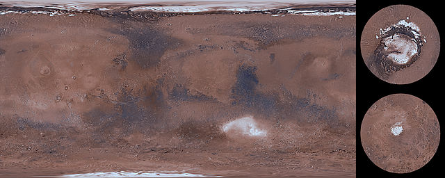
English: This global image map of Mars has a resolution of approximately 1.0 km/pixel at the equator. It is a reduced version of a much larger map with 231 m/pixel resolution at the equator. The colorized mosaic was completed by NASA Ames which warped the original Viking colorized mosaic and blended over the latest black/white mosaic. The full resolution mosaic is known as Colorized Mars Digital Image Model (MDIM) 2.1. MDIM 2.1 replaces two earlier mosaics produced by the USGS from the same set of approximately 4600 Viking Orbiter images. The positional accuracy of features in MDIM 2.1 is estimated to be roughly one pixel (200 m), compared to 3 km for MDIM 2.0 released in 2001 and >6 km for MDIM 1.0 released in 1991. In addition to relatively imprecise geodetic control, the previous mosaics were affected by changing definitions of cartographic parameters (such as the definition of zero longitude), resulting in an overall longitude shift of as much as 0.2° between the early MDIMs and other datasets. The new mosaic uses the most recent coordinate system definitions for Mars. These definitions have been widely adopted by NASA missions and other users of planetary data and are likely to remain in use for a decade or more. As a result, MDIM 2.1 not only registers precisely with data from current missions, such as MGS and 2001 Mars Odyssey, but will serve as an accurate basemap on which data from future missions can be plotted. The images used to make MDIM 2.1 were obtained primarily through the red, clear, and minus-blue filters of the Viking Orbiter imaging system, and thus provide a monochromatic view of Mars weighted toward the red end of the visible spectrum. Images were obtained with a wide range of solar incidence angles. It is unfortunately not possible to correct the appearance of both albedo (reflectivity) variations and topographic features for these incidence angle variations simultaneously. The images have therefore been highpass-filtered at a scale of ~50 km to remove regional albedo variations and then normalized so that equal topographic slopes appear with equal contrast everywhere. Photometric processing for MDIM 2.1 incorporates a model of the transmission and scattering of light in the atmosphere that is substantially improved over that used in MDIM 2.0. Residual tonal mismatches between different images after photometric correction were corrected based on a least-squares adjustment of image brightness and contrast. Because of these photometric and cosmetic improvements, it was possible to use a less severe highpass filter than for MDIM 2.0, improving the overall appearance of the mosaic. The original USGS polar mosaics were increased in size by a linear factor of 1.6 and given margins before being appended to the USGS global mosaic. |
| تاریخ | |
| منبع | https://astrogeology.usgs.gov/search/details/Mars/Viking/MDIM21/Mars_Viking_MDIM21_ClrMosaic_global_232m/cub |
| پدیدآور | NASA / Jet Propulsion Lab / USGS |
| دیگر نسخهها |
|


اجازهنامه
این اثر در مالکیت عمومی در ایالات متحده قرار دارد به این دلیل که اثر از دولت فدرال ایالات متحده تحت شرایط Title 17, Chapter 1, Section 105 of the US Code قرار دارد. حق تکثیر را ببینید.
توجه: این فقط برای آثاری که دولت فدرال ایجاد کرده صدق میکند و نه هر کار شخصی در ایالتهای ایالات متحده، قلمروها، اجتماعها، شهرستان، شهردار، یا هر تقسیم بندی دیگری. این الگو همچنین در رابطه با تمبرهای پستی طراحی و منتشر شده توسط خدمات پستی ایالات متحده از ۱۹۸۷ صدق نمیکند. (206.02(b) of Compendium II: Copyright Office Practices را ببینید). این همچنین در رابطه با سکههای ایالات متحده صدق نمیکند، The US Mint Terms of Use. را ببینید.
|
 | |
| این پرونده تحت قانون حق تکثیر محدودیت آزاد منتشر شده که شامل تمامی حقوق مربوطه و حقوق نزدیک به آن میشود. | ||
تاریخچهٔ پرونده
روی تاریخ/زمانها کلیک کنید تا نسخهٔ مربوط به آن هنگام را ببینید.
| تاریخ/زمان | بندانگشتی | ابعاد | کاربر | توضیح | |
|---|---|---|---|---|---|
| کنونی | ۱۴ مارس ۲۰۱۴، ساعت ۰۶:۳۰ | ۲۶٬۶۷۴ در ۱۰٬۶۷۰ (۴۶٫۲۶ مگابایت) | WolfmanSF | User created page with UploadWizard |
کاربرد پرونده
صفحهٔ زیر از این تصویر استفاده میکند:
کاربرد سراسری پرونده
ویکیهای دیگر زیر از این پرونده استفاده میکنند:
- کاربرد در ar.wikipedia.org
- کاربرد در el.wikipedia.org
- کاربرد در en.wikipedia.org
- کاربرد در hr.wikipedia.org
- کاربرد در uk.wikipedia.org
- کاربرد در vi.wikipedia.org