پرونده:Map of ancient Epirus and environs (English).svg

Page contents not supported in other languages.
از ویکی‌پدیا، دانشنامهٔ آزاد

پروندهٔ اصلی(پروندهٔ اس‌وی‌جی، با ابعاد ۱٬۳۰۳ × ۱٬۵۰۰ پیکسل، اندازهٔ پرونده: ۴۹۵ کیلوبایت)

این پرونده را ترجمه کنید این پروندهٔ اس‌وی‌جی از متن جاسازی‌شده استفاده می‌کند که به‌سادگی می‌توان با این ابزار خودکار آن را به زبانتان ترجمه کرد (اطلاعات بیشتر).

همچنین می‌توانید تصویر را دریافت و با یک ویرایشگر متن به طور دستی آن را ویرایش کنید.

خلاصه

توضیح
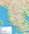
English: Map of ancient Epirus & Environs, Thracian, Illyrian, Paeonian, & Greek contact zones with illustration and extent of Hellenization up to the creation of Epirus Nova or Illyria Graeca
تاریخ
منبع اثر شخصی
پدیدآور MaryroseB54
دیگر نسخه‌ها

[ویرایش]

  • The classical age of Greece (1999),
  • ed. Atlas of the Greek and Roman world in antiquity (1981).
  • Hammond, N. G. L. A History of Greece to 322 B.C., 1986, ISBN-10: 0198730950
  • Wilkes, J. J. The Illyrians, 1992,ISBN 0631198075, (i.e. pages 174, 208, 210, 273)
  • In the Shadow of Olympus: The Emergence of Macedon,ISBN 0691008809,1992
  • Thracian Tribal areas (from Fol, Thrace and the Thracians, p 133),The Thracians 700 BC–AD 46 (Men-at-Arms 360) by Christopher Webber After Hoddinot, Col & Cah
  • Hendry, p. 299. The geography is entirely correct for Servius' time, since Diocletian's rearrangement of provincial boundaries included the creation of the province of Epirus Nova out of southern Illyricum with Dyrrachium (=Epidamnus) as its capital.
  • The Loeb Editor's Notes, 28 Nova Epirus or Illyris Graeca (Epirus, Nova Illyria Graeca) "Nova Epirus or Illyris Graeca extended from the Drilo (Mod. Drina) River on the north to the Ceraunian Mts. on the south, thus comprising a large part of modern Albania. Immediately to the south of it to the Ambracian Gulf (Mod. Gulf of Arta) lay what is here called Old Epirus, approximately identical with the Epirus of modern Greece."
  • Soustal, Peter; Koder, Johannes (1981). Tabula Imperii Byzantini, Band 3: Nikopolis und Kephallenia (in German). Vienna: Verlag der Osterreichischen Akademie der Wissenschaften. ISBN 3-7001-0399-9., page 47
  • A new classical dictionary of Greek and Roman biography, mythology, and geography: partly based upon the Dictionary of Greek and Roman biography and mythology by Sir William Smith,1851,page 392 "B. Illyris Graeca, which was called in later times Epirus Nova, extended from the river Drilo to the SE., up to the Ceraunian mountains, which separated it from Epirus Proper"
  • American journal of philology, Τόμοι 98-99,by JSTOR (Organization), Project Muse,1977,page 263, the partly Hellenic and partly Hellenized Epirus Nova
  • Epirus Vetus: The Archaeology of a Late Antique Province (Duckworth Archaeology) by William Bowden,2003,ISBN-10: 0715631160,2003,page 233,of Lissos in Epirus Nova
  • Migrations and invasions in Greece and adjacent areas by Nicholas Geoffrey Lempriere Hammond,1976,ISBN -0815550472,page 54,The line of division between Illyricum and the Greek area Epirus nova
  • Athanassakis, A.N. (1977), "N.G.L. Hammond, Migrations and Invasions in Greece and Adjacent Areas (review)", American Journal of Philology 99: 263–6, JSTOR 293653
  • Hammond, N. G. L. A History of Greece to 322 B.C., 1986, ISBN-10: 0198730950
  • Triadafilopoulos, Triadafilos (November 2000). "Power politics and nationalist discourse in the struggle for 'Northern Epirus': 1919-1921". Journal of Southern Europe and the Balkans,
  • Encyclopedia Britannica,2002,ISBN -0852297874,The Roman province of Illyricum stretched from the Drilon River (the Drin, in modern Albania) in the south to Istria (modem Slovenia and Croatia)
  • History of the Byzantine Empire: Vol. 1, 324-1453 (Paperback) by Alexander A. Vasiliev
  • Epire, Illyrie, Macedoine: melanges offerts au professeur Pierre Cabanes by Daniele Berranger,Pierre Cabanes,Daniele Berranger-Auserve,page 130
  • In An Inventory of Archaic and Classical Poleis by Mogens Herman, ISBN 0-19-814099-1, 2004, i.e. "As a long-distance trading community, Aigina was not an active coloniser, but colonised Kydonia (no. 968) in 519, Adria (no. 75) c.C61, and Damastion in Illyria after 431 (Strabo 8.6.16)." & page 348
  • The Cambridge Ancient History: The Hellenistic monarchies and the rise of Rome, 1964. page 836 "of mixed barbarian and Greek population, such as Dimale (or Dimallum), of unknown"
  • The Illyrian Atintani, the Epirotic Atintanes and the Roman Protectorate N. G. L. Hammond, The Journal of Roman Studies Vol. 79 (1989), pp. 11-25 "There were Illyrian Amantini in Pannonia and Greek Amantes in North Epirus"
  • Blank map from Image:Map greek sanctuaries-fr.svg (The empty map used is not topographic, nor does it offer the capacity of gps precision, but its easy on the eyes and aesthetically pleasing in general)

اجازه‌نامه

من، صاحب حقوق قانونی این اثر، به این وسیله این اثر را تحث اجازه‌نامهٔ ذیل منتشر می‌کنم:
w:fa:کرییتیو کامنز
انتساب انتشار مشابه
این پرونده تحت پروانهٔ Creative Commons Attribution-Share Alike 4.0 International منتشر شده است.
شما اجازه دارید:
  • برای به اشتراک گذاشتن – برای کپی، توزیع و انتقال اثر
  • تلفیق کردن – برای انطباق اثر
تحت شرایط زیر:
  • انتساب – شما باید اعتبار مربوطه را به دست آورید، پیوندی به مجوز ارائه دهید و نشان دهید که آیا تغییرات ایجاد شده‌اند یا خیر. شما ممکن است این کار را به هر روش منطقی انجام دهید، اما نه به هر شیوه‌ای که پیشنهاد می‌کند که مجوزدهنده از شما یا استفاده‌تان حمایت کند.
  • انتشار مشابه – اگر این اثر را تلفیق یا تبدیل می‌کنید، یا بر پایه‌ آن اثری دیگر خلق می‌کنید، می‌‌بایست مشارکت‌های خود را تحت مجوز یکسان یا مشابه با ا اصل آن توزیع کنید.
برچسب‌ها
InfoField
این نگاره برچسپ‌گذاری شده‌است: برچسپ‌ها را در ویکی‌انبار مشاهده کنید

عنوان

شرحی یک‌خطی از محتوای این فایل اضافه کنید

آیتم‌هایی که در این پرونده نمایش داده شده‌اند

توصیف‌ها

این خصوصیت مقداری دارد اما نامشخص است.

source of file انگلیسی

تاریخچهٔ پرونده

روی تاریخ/زمان‌ها کلیک کنید تا نسخهٔ مربوط به آن هنگام را ببینید.

تاریخ/زمانبندانگشتیابعادکاربرتوضیح
کنونی‏۲۲ نوامبر ۲۰۲۱، ساعت ۰۴:۳۸تصویر بندانگشتی از نسخهٔ مورخ ‏۲۲ نوامبر ۲۰۲۱، ساعت ۰۴:۳۸۱٬۳۰۳ در ۱٬۵۰۰ (۴۹۵ کیلوبایت)KhirurgMeant to upload this version
‏۲۲ نوامبر ۲۰۲۱، ساعت ۰۴:۲۲تصویر بندانگشتی از نسخهٔ مورخ ‏۲۲ نوامبر ۲۰۲۱، ساعت ۰۴:۲۲۱٬۳۰۳ در ۱٬۵۰۰ (۴۹۵ کیلوبایت)KhirurgMade some corrections
‏۲۸ دسامبر ۲۰۲۰، ساعت ۰۱:۳۶تصویر بندانگشتی از نسخهٔ مورخ ‏۲۸ دسامبر ۲۰۲۰، ساعت ۰۱:۳۶۱٬۳۰۳ در ۱٬۵۰۰ (۴۹۳ کیلوبایت)CastellFile uploaded using svgtranslate tool (https://svgtranslate.toolforge.org/). Added translation for ca.
‏۲۸ دسامبر ۲۰۲۰، ساعت ۰۱:۲۶تصویر بندانگشتی از نسخهٔ مورخ ‏۲۸ دسامبر ۲۰۲۰، ساعت ۰۱:۲۶۱٬۳۰۳ در ۱٬۵۰۰ (۴۹۲ کیلوبایت)CastellFile uploaded using svgtranslate tool (https://svgtranslate.toolforge.org/). Added translation for ca.
‏۲۴ ژوئن ۲۰۱۶، ساعت ۱۱:۱۵تصویر بندانگشتی از نسخهٔ مورخ ‏۲۴ ژوئن ۲۰۱۶، ساعت ۱۱:۱۵۱٬۳۰۳ در ۱٬۵۰۰ (۳۸۳ کیلوبایت)MaryroseB54Parthos
‏۲۲ ژوئن ۲۰۱۶، ساعت ۲۳:۵۸تصویر بندانگشتی از نسخهٔ مورخ ‏۲۲ ژوئن ۲۰۱۶، ساعت ۲۳:۵۸۱٬۳۰۳ در ۱٬۵۰۰ (۳۸۲ کیلوبایت)MaryroseB54as per source
‏۲۲ ژوئن ۲۰۱۶، ساعت ۲۲:۵۲تصویر بندانگشتی از نسخهٔ مورخ ‏۲۲ ژوئن ۲۰۱۶، ساعت ۲۲:۵۲۱٬۳۰۳ در ۱٬۵۰۰ (۳۸۲ کیلوبایت)MaryroseB54Position
‏۲۲ ژوئن ۲۰۱۶، ساعت ۲۱:۰۷تصویر بندانگشتی از نسخهٔ مورخ ‏۲۲ ژوئن ۲۰۱۶، ساعت ۲۱:۰۷۱٬۳۰۳ در ۱٬۵۰۰ (۳۸۲ کیلوبایت)MaryroseB54Position fix
‏۲۰ ژوئن ۲۰۱۶، ساعت ۱۰:۰۶تصویر بندانگشتی از نسخهٔ مورخ ‏۲۰ ژوئن ۲۰۱۶، ساعت ۱۰:۰۶۱٬۳۰۳ در ۱٬۵۰۰ (۳۸۲ کیلوبایت)MaryroseB54User created page with UploadWizard

صفحه‌های زیر از این تصویر استفاده می‌کنند:

کاربرد سراسری پرونده

ویکی‌های دیگر زیر از این پرونده استفاده می‌کنند:

نمایش استفاده‌های سراسری از این پرونده.

فراداده