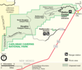
پرونده:Map of Carlsbad Caverns National Park.png

اندازهٔ این پیشنمایش: ۷۰۵ × ۶۰۰ پیکسل. کیفیتهای دیگر: ۲۸۲ × ۲۴۰ پیکسل | ۵۶۴ × ۴۸۰ پیکسل | ۹۰۳ × ۷۶۸ پیکسل | ۱٬۲۰۴ × ۱٬۰۲۴ پیکسل | ۲٬۴۰۸ × ۲٬۰۴۸ پیکسل | ۳٬۱۲۱ × ۲٬۶۵۵ پیکسل.
پروندهٔ اصلی (۳٬۱۲۱ × ۲٬۶۵۵ پیکسل، اندازهٔ پرونده: ۷۰۴ کیلوبایت، نوع MIME پرونده: image/png)
تاریخچهٔ پرونده
روی تاریخ/زمانها کلیک کنید تا نسخهٔ مربوط به آن هنگام را ببینید.
| تاریخ/زمان | بندانگشتی | ابعاد | کاربر | توضیح | |
|---|---|---|---|---|---|
| کنونی | ۲۶ ژوئن ۲۰۲۲، ساعت ۰۰:۱۰ |  | ۳٬۱۲۱ در ۲٬۶۵۵ (۷۰۴ کیلوبایت) | Joliv | Update to current NPS version (different spellings, better rasterization, removed ranger stn) |
| ۲۳ مارس ۲۰۰۸، ساعت ۱۰:۴۰ |  | ۱٬۱۰۴ در ۹۳۶ (۱۱۳ کیلوبایت) | Finavon | border cropped | |
| ۲۵ اوت ۲۰۰۶، ساعت ۰۶:۰۰ |  | ۱٬۱۴۵ در ۹۴۵ (۱۴۰ کیلوبایت) | Huebi~commonswiki | {{Information |Description=Map of Carlsbad Caverns National Park |Source=http://www.nps.gov |Date= |Author= |Permission= |other_versions= }} {{PD-USGov-NPS}} category:Carlsbad Caverns National Park |
کاربرد پرونده
صفحهٔ زیر از این تصویر استفاده میکند:
کاربرد سراسری پرونده
ویکیهای دیگر زیر از این پرونده استفاده میکنند:
- کاربرد در ca.wikipedia.org
- کاربرد در da.wikipedia.org
- کاربرد در de.wikipedia.org
- کاربرد در en.wikipedia.org
- کاربرد در fr.wikipedia.org
- کاربرد در hr.wikipedia.org
- کاربرد در ko.wikipedia.org
- کاربرد در nl.wikipedia.org
- کاربرد در pl.wikipedia.org
- کاربرد در ro.wikipedia.org
- کاربرد در tr.wikipedia.org

