
پرونده:Manistique Michigan aerial view.jpg

اندازهٔ این پیشنمایش: ۸۰۰ × ۵۶۲ پیکسل. کیفیتهای دیگر: ۳۲۰ × ۲۲۵ پیکسل | ۶۴۰ × ۴۴۹ پیکسل | ۱٬۰۲۴ × ۷۱۹ پیکسل | ۱٬۲۸۰ × ۸۹۹ پیکسل | ۱٬۵۰۰ × ۱٬۰۵۳ پیکسل.
پروندهٔ اصلی (۱٬۵۰۰ × ۱٬۰۵۳ پیکسل، اندازهٔ پرونده: ۶۰۱ کیلوبایت، نوع MIME پرونده: image/jpeg)
این پرونده در ویکیانبار موجود است. محتویات صفحهٔ توصیف آن در زیر نمایش داده میشود. |
| توضیح |
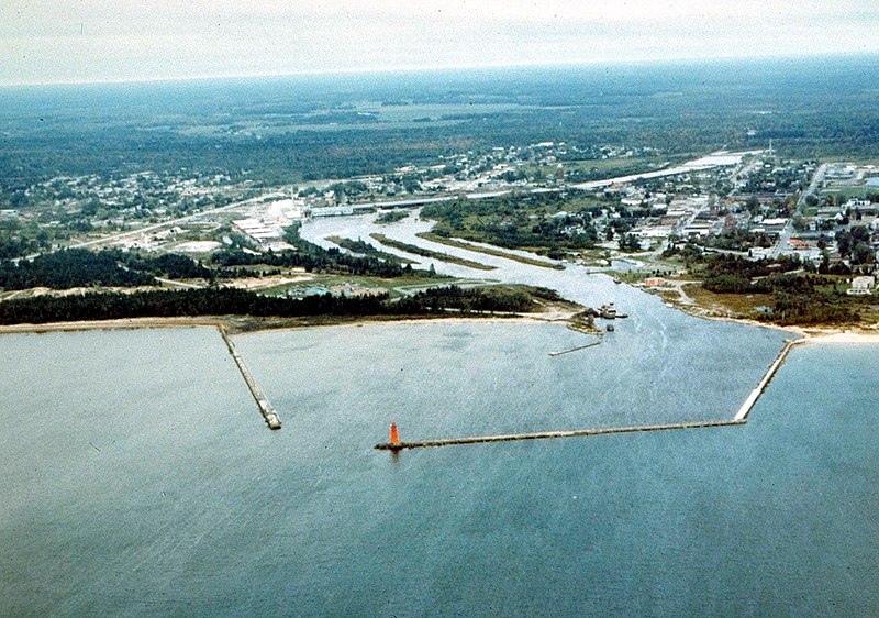
English: Aerial view of Manistique, Michigan, USA. The city lies on the northern shore of Lake Michigan in the Upper Peninsula of Michigan. The Manistique River flows through the town and into Lake Michigan through the harbor. |
|||
| تاریخ | not specified or unknown | |||
| منبع |
U.S. Army Corps of Engineers Digital Visual Library Image page Image description page Digital Visual Library home page |
|||
| پدیدآور | U.S. Army Corps of Engineers, photographer not specified or unknown | |||
| اجازهنامه (استفادهٔ مجدد از این پرونده) |
|
|||
| مکان | Manistique, Schoolcraft County, Michigan, USA |
| مختصات دوربین | | محل قرارگیری این نگاره و سایر نگارهها در: نقشهٔ شهری باز |
|---|
تاریخچهٔ پرونده
روی تاریخ/زمانها کلیک کنید تا نسخهٔ مربوط به آن هنگام را ببینید.
| تاریخ/زمان | بندانگشتی | ابعاد | کاربر | توضیح | |
|---|---|---|---|---|---|
| کنونی | ۳۰ مارس ۲۰۰۷، ساعت ۰۱:۳۰ | | ۱٬۵۰۰ در ۱٬۰۵۳ (۶۰۱ کیلوبایت) | DanMS | {{Information | Description = {{en|Aerial view of Manistique, Michigan, USA. The city lies on the northern shore of Lake Michigan in the Upper Peninsula of Michigan. The Manistique River flows through the town and into Lake Michigan through the harbor. |
کاربرد پرونده
صفحهٔ زیر از این تصویر استفاده میکند:
کاربرد سراسری پرونده
ویکیهای دیگر زیر از این پرونده استفاده میکنند:
- کاربرد در ar.wikipedia.org
- کاربرد در arz.wikipedia.org
- کاربرد در azb.wikipedia.org
- کاربرد در ceb.wikipedia.org
- کاربرد در ce.wikipedia.org
- کاربرد در cy.wikipedia.org
- کاربرد در en.wikipedia.org
- کاربرد در es.wikipedia.org
- کاربرد در eu.wikipedia.org
- کاربرد در fr.wikipedia.org
- کاربرد در hu.wikipedia.org
- کاربرد در it.wikipedia.org
- کاربرد در ky.wikipedia.org
- کاربرد در lld.wikipedia.org
- کاربرد در pl.wikipedia.org
- کاربرد در pt.wikipedia.org
- کاربرد در ro.wikipedia.org
- کاربرد در sh.wikipedia.org
- کاربرد در sr.wikipedia.org
- کاربرد در sv.wikipedia.org
- کاربرد در tr.wikipedia.org
- کاربرد در tt.wikipedia.org
- کاربرد در uk.wikipedia.org
- کاربرد در uz.wikipedia.org
- کاربرد در www.wikidata.org
- کاربرد در zh-min-nan.wikipedia.org
- کاربرد در zh.wikipedia.org