
پرونده:London - John Norden's map of 1593.jpg

پروندهٔ اصلی (۴٬۰۰۰ × ۳٬۷۶۰ پیکسل، اندازهٔ پرونده: ۴٫۰۱ مگابایت، نوع MIME پرونده: image/jpeg)
این پرونده در ویکیانبار موجود است. محتویات صفحهٔ توصیف آن در زیر نمایش داده میشود. |
| توضیح |
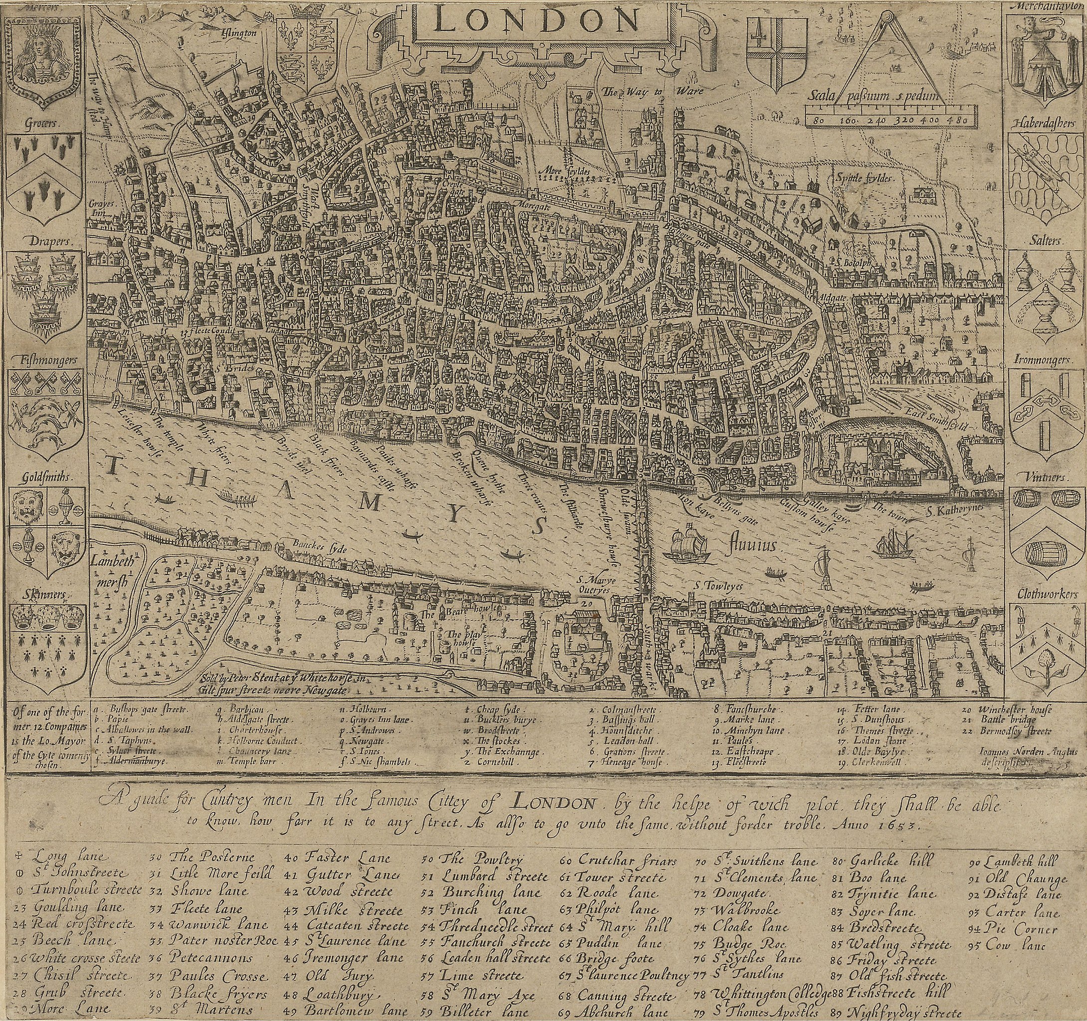
English: A guide for Cuntrey men In the famous Cittey of London. A map of London by John Norden, 1593. This copy comes from the 1653 edition of Norden's Speculum Britainiæ (Mirror of Britain), re-issued after his death.
There is only one bridge across the Thames, but parts of Southwark on the south bank of the river have been developed. The coats of arms around the edge belong to the twelve largest city guilds. These arms collectively were known as the "Great Liveries". Top right is the Merchant Tailors' arms.
|
||||
| تاریخ | 1593, re-issued in 1653 | ||||
| منبع | British Library: http://www.bl.uk/onlinegallery/onlineex/crace/a/007000000000001u00033000.html | ||||
| پدیدآور | John Norden | ||||
| اجازهنامه (استفادهٔ مجدد از این پرونده) |
|
||||
تاریخچهٔ پرونده
روی تاریخ/زمانها کلیک کنید تا نسخهٔ مربوط به آن هنگام را ببینید.
| تاریخ/زمان | بندانگشتی | ابعاد | کاربر | توضیح | |
|---|---|---|---|---|---|
| کنونی | ۱۹ فوریهٔ ۲۰۱۰، ساعت ۰۲:۴۹ | | ۴٬۰۰۰ در ۳٬۷۶۰ (۴٫۰۱ مگابایت) | Inductiveload | much higher res version |
| ۲۱ مهٔ ۲۰۰۷، ساعت ۱۰:۵۴ |  | ۵۰۰ در ۳۳۵ (۴۳ کیلوبایت) | Thomas Reid | {{Information |Description=John Norden's map of London in 1593. There is only one bridge across the Thames, but parts of en:Southwark on the south bank of the river have been developed. |Source=Originally from [http://en.wikipedia.org en.wikipedia]; |
کاربرد پرونده
صفحههای زیر از این تصویر استفاده میکنند:
کاربرد سراسری پرونده
ویکیهای دیگر زیر از این پرونده استفاده میکنند:
- کاربرد در ar.wikipedia.org
- کاربرد در be-tarask.wikipedia.org
- کاربرد در be.wikipedia.org
- کاربرد در bg.wikipedia.org
- کاربرد در en.wikipedia.org
- کاربرد در en.wikibooks.org
- کاربرد در eo.wikipedia.org
- کاربرد در es.wikipedia.org
- کاربرد در ga.wikipedia.org
- کاربرد در he.wikipedia.org
- کاربرد در hr.wikipedia.org
- کاربرد در hu.wikipedia.org
- کاربرد در hy.wikipedia.org
- کاربرد در it.wikipedia.org
- کاربرد در ja.wikipedia.org
- کاربرد در kn.wikipedia.org
- کاربرد در ko.wikipedia.org
- کاربرد در my.wikipedia.org
- کاربرد در ro.wikipedia.org
- کاربرد در ru.wikipedia.org
- کاربرد در sco.wikipedia.org
- کاربرد در sh.wikipedia.org
- کاربرد در sl.wikipedia.org
- کاربرد در tum.wikipedia.org
- کاربرد در uk.wikipedia.org
- کاربرد در vi.wikipedia.org
- کاربرد در zh.wikipedia.org