
پرونده:Kotzebue Alaska aerial view.jpg

اندازهٔ این پیشنمایش: ۸۰۰ × ۶۰۰ پیکسل. کیفیتهای دیگر: ۳۲۰ × ۲۴۰ پیکسل | ۶۴۰ × ۴۸۰ پیکسل | ۱٬۰۲۴ × ۷۶۸ پیکسل | ۱٬۲۸۰ × ۹۶۰ پیکسل | ۱٬۵۰۰ × ۱٬۱۲۵ پیکسل.
پروندهٔ اصلی (۱٬۵۰۰ × ۱٬۱۲۵ پیکسل، اندازهٔ پرونده: ۳۷۲ کیلوبایت، نوع MIME پرونده: image/jpeg)
این پرونده در ویکیانبار موجود است. محتویات صفحهٔ توصیف آن در زیر نمایش داده میشود. |
| توضیح |
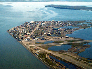
English: Aerial view of Kotzebue, Alaska, U.S. |
|||
| مکان | Kotzebue, Alaska, U.S. 66°53′49.97″N 162°35′8.3″W / 66.8972139°N 162.585639°W |
|||
| تاریخ | ||||
| منبع |
U.S. Army Corps of Engineers Digital Visual Library Image page Image description page Digital Visual Library home page |
|||
| پدیدآور | U.S. Army Corps of Engineers, photographer not specified or unknown | |||
| اجازهنامه (استفادهٔ مجدد از این پرونده) |
|
تاریخچهٔ پرونده
روی تاریخ/زمانها کلیک کنید تا نسخهٔ مربوط به آن هنگام را ببینید.
| تاریخ/زمان | بندانگشتی | ابعاد | کاربر | توضیح | |
|---|---|---|---|---|---|
| کنونی | ۲۱ مارس ۲۰۰۷، ساعت ۰۳:۴۲ | | ۱٬۵۰۰ در ۱٬۱۲۵ (۳۷۲ کیلوبایت) | DanMS | {{Information | Description = {{en|Aerial view of Kotzebue, Alaska, USA.}} | Source = U.S. Army Corps of Engineers Digital Visual Library<br />[http://images.usace.army.mil/images/Hires/cepoa170.jpg Image page]<br />[http://images.usace.army.mi |
کاربرد پرونده
صفحهٔ زیر از این تصویر استفاده میکند:
کاربرد سراسری پرونده
ویکیهای دیگر زیر از این پرونده استفاده میکنند:
- کاربرد در ar.wikipedia.org
- کاربرد در azb.wikipedia.org
- کاربرد در az.wikipedia.org
- کاربرد در bg.wikipedia.org
- کاربرد در ca.wikipedia.org
- کاربرد در ceb.wikipedia.org
- کاربرد در ch.wikipedia.org
- کاربرد در de.wikipedia.org
- کاربرد در es.wikipedia.org
- کاربرد در fi.wikipedia.org
- کاربرد در fr.wikipedia.org
- کاربرد در fr.wikivoyage.org
- کاربرد در he.wikipedia.org
- کاربرد در ik.wikipedia.org
- کاربرد در it.wikipedia.org
- کاربرد در ko.wikipedia.org
- کاربرد در mg.wikipedia.org
- کاربرد در ml.wikipedia.org
- کاربرد در mrj.wikipedia.org
- کاربرد در mt.wikipedia.org
- کاربرد در nl.wikipedia.org
- کاربرد در nn.wikipedia.org
- کاربرد در no.wikipedia.org
- کاربرد در pl.wikipedia.org
- کاربرد در pt.wikipedia.org
- کاربرد در ru.wikipedia.org
- کاربرد در sh.wikipedia.org
- کاربرد در simple.wikipedia.org
- کاربرد در sr.wikipedia.org
- کاربرد در sv.wikipedia.org
- کاربرد در szl.wikipedia.org
- کاربرد در tly.wikipedia.org
- کاربرد در tr.wikipedia.org
- کاربرد در uk.wikipedia.org
- کاربرد در ur.wikipedia.org
- کاربرد در uz.wikipedia.org
- کاربرد در www.wikidata.org
- کاربرد در zh-min-nan.wikipedia.org