پرونده:Fort Delaware LOC 384066pu.jpg

Page contents not supported in other languages.
از ویکی‌پدیا، دانشنامهٔ آزاد

پروندهٔ اصلی(۳٬۸۶۷ × ۳٬۰۲۵ پیکسل، اندازهٔ پرونده: ۱٫۶۸ مگابایت، نوع MIME پرونده: image/jpeg)

This is an image of a place or building that is listed on the National Register of Historic Places in the United States of America. Its reference number is 71000226.

توضیح 
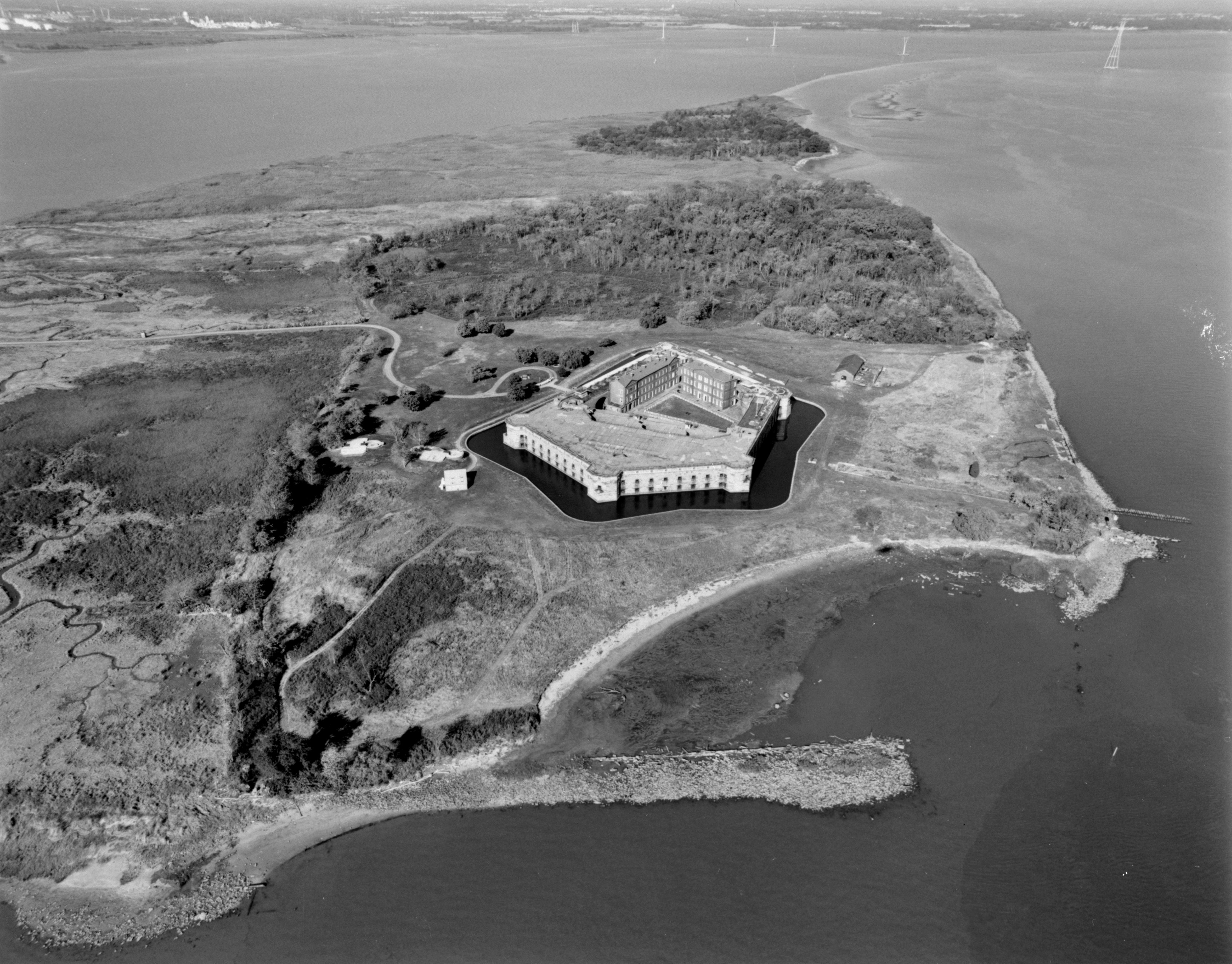
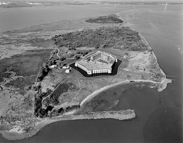
NORTHWEST OBLIQUE AERIAL VIEW OF FORT DELAWARE AND PEA PATCH ISLAND. REMAINS OF SEA WALL VISIBLE IN FOREGROUND AND RIGHT OF IMAGE. HAER DEL,2-DELAC.V,1A-1 Photo taken in October, 1998.
تاریخ
منبع
این نگاره از کتابخانهٔ کنگره ایالات متحده بخش چاپ و عکس‌ها تحت شناسهٔ دیجیتالی hhh.de0498 موجود است.

این برچست وضعیت حق تکثیر اثر ضمیمه شده را مشخص نمی‌کند. یک برچسپ معمولی همچنان مورد نیاز است. Commons:Licensing را برای کسب اطلاعات مشاهده فرمایید.

العربية  беларуская (тарашкевіца)  বাংলা  čeština  Deutsch  English  español  فارسی  suomi  français  galego  עברית  magyar  Bahasa Indonesia  italiano  日本語  lietuvių  македонски  മലയാളം  Nederlands  polski  português  português do Brasil  română  русский  sicilianu  slovenčina  slovenščina  Türkçe  українська  简体中文  繁體中文  +/−

پدیدآور Michael Swanda, U.S. Army Corps of Enginers
اجازه‌نامه
(استفادهٔ مجدد از این پرونده)
Public domain
This image or file is a work of a U.S. Army Corps of Engineers soldier or employee, taken or made as part of that person's official duties. As a work of the U.S. federal government, the image is in the public domain.

English | italiano | Nederlands | پښتو | русский | sicilianu | slovenščina | Türkçe | українська | +/−

Public domain This image or media file contains material based on a work of a National Park Service employee, created as part of that person's official duties. As a work of the U.S. federal government, such work is in the public domain in the United States. See the NPS website and NPS copyright policy for more information.
مختصات شیء۳۹° ۳۵′ ۲۴″ N, ۷۵° ۳۴′ ۱۹″ W Kartographer map based on OpenStreetMap.محل قرارگیری این نگاره و سایر نگاره‌ها در: نقشهٔ شهری بازinfo

عنوان

شرحی یک‌خطی از محتوای این فایل اضافه کنید

آیتم‌هایی که در این پرونده نمایش داده شده‌اند

توصیف‌ها

Fort Delaware انگلیسی

39°35'24"N, 75°34'12"W

تاریخچهٔ پرونده

روی تاریخ/زمان‌ها کلیک کنید تا نسخهٔ مربوط به آن هنگام را ببینید.

تاریخ/زمانبندانگشتیابعادکاربرتوضیح
کنونی‏۶ مهٔ ۲۰۰۷، ساعت ۰۰:۵۴تصویر بندانگشتی از نسخهٔ مورخ ‏۶ مهٔ ۲۰۰۷، ساعت ۰۰:۵۴۳٬۸۶۷ در ۳٬۰۲۵ (۱٫۶۸ مگابایت)Balcer~commonswikiORTHWEST OBLIQUE AERIAL VIEW OF FORT DELAWARE AND PEA PATCH ISLAND. REMAINS OF SEA WALL VISIBLE IN FOREGROUND AND RIGHT OF IMAGE. HAER DEL,2-DELAC.V,1A-1 {{LOC-image|id=hhh.de0498}} == Licensing == {{HAER|DEL,2-DELAC.V,1A-}}

صفحهٔ زیر از این تصویر استفاده می‌کند:

کاربرد سراسری پرونده

ویکی‌های دیگر زیر از این پرونده استفاده می‌کنند:

فراداده