
پرونده:Finchmap.jpg
اندازهٔ این پیشنمایش: ۵۶۶ × ۶۰۰ پیکسل. کیفیتهای دیگر: ۲۲۶ × ۲۴۰ پیکسل | ۵۶۹ × ۶۰۳ پیکسل.
پروندهٔ اصلی (۵۶۹ × ۶۰۳ پیکسل، اندازهٔ پرونده: ۹۷ کیلوبایت، نوع MIME پرونده: image/jpeg)
این پرونده در ویکیانبار موجود است. محتویات صفحهٔ توصیف آن در زیر نمایش داده میشود. |
| توضیح |
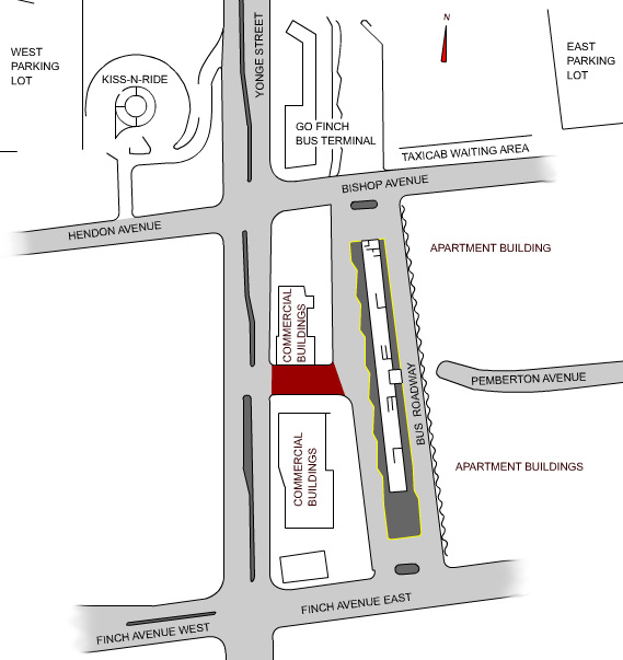
English: A map of the Finch subway station bus terminal and surrounding facilities in Toronto, Canada. The maroon path is the Pemberton exit completed by the end of 2006. The terminal is the facility in the middle-right of the image.
The map was drawn from scratch by me, based on a press release diagram from the Toronto Transit Commission, and satellite photos from Google. TheHYPO 09:22, 12 June 2006 (UTC) |
||
| تاریخ | |||
| منبع | Transferred from en.wikipedia. | ||
| پدیدآور | en:User:TheHYPO | ||
| اجازهنامه (استفادهٔ مجدد از این پرونده) |
|
سیاهه بارگذاری اصلی
The original description page is/was here. All following user names refer to en.wikipedia.
- 2006-06-12 10:28 TheHYPO 569×603 (97 KB)
تاریخچهٔ پرونده
روی تاریخ/زمانها کلیک کنید تا نسخهٔ مربوط به آن هنگام را ببینید.
| تاریخ/زمان | بندانگشتی | ابعاد | کاربر | توضیح | |
|---|---|---|---|---|---|
| کنونی | ۲۹ ژوئیهٔ ۲۰۱۰، ساعت ۱۴:۴۹ | | ۵۶۹ در ۶۰۳ (۹۷ کیلوبایت) | Voyager | {{Information |Description={{en|A map of the Finch subway station bus terminal and surrounding facilities in Toronto, Canada. The maroon path is the Pemberton exit completed by the end of 2006. The terminal is the facility in the middle-right of the image |
کاربرد پرونده
صفحهٔ زیر از این تصویر استفاده میکند:
کاربرد سراسری پرونده
ویکیهای دیگر زیر از این پرونده استفاده میکنند:
- کاربرد در de.wikipedia.org
- کاربرد در en.wikipedia.org
- کاربرد در ko.wikipedia.org