
پرونده:Division of Gaul - 587.jpg
پروندهٔ اصلی (۱٬۲۳۵ × ۱٬۱۵۳ پیکسل، اندازهٔ پرونده: ۳۵۷ کیلوبایت، نوع MIME پرونده: image/jpeg)
این پرونده در ویکیانبار موجود است. محتویات صفحهٔ توصیف آن در زیر نمایش داده میشود. |
خلاصه
| توضیح |
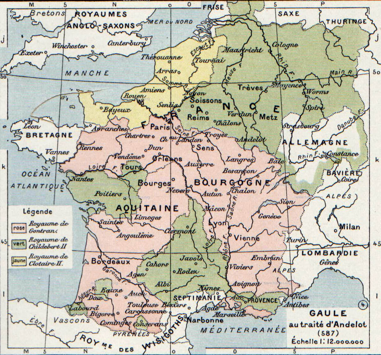
English: The map comes from Vidal-Lablache, Atlas général d'histoire et de géographie (1894). It shows Gaul in 587 AD.
Français : Gaule au traité d'Andelot (587). Paul Vidal de La Blache, Atlas général d'histoire et de géographie (1894).
Русский: Карта владений Меровингов из книги. |
||||||||||||||||||||
| تاریخ | |||||||||||||||||||||
| منبع | Paul Vidal de La Blache, Atlas général d'histoire et de géographie (1894). | ||||||||||||||||||||
| پدیدآور |
|
||||||||||||||||||||
| دیگر نسخهها | |||||||||||||||||||||

.jpg)
اجازهنامه
This image is in the public domain because it is a mere mechanical scan or photocopy of a public domain original, or – from the available evidence – is so similar to such a scan or photocopy that no copyright protection can be expected to arise. The original itself is in the public domain for the following reason:
This tag is designed for use where there may be a need to assert that any enhancements (eg brightness, contrast, colour-matching, sharpening) are in themselves insufficiently creative to generate a new copyright. It can be used where it is unknown whether any enhancements have been made, as well as when the enhancements are clear but insufficient. For known raw unenhanced scans you can use an appropriate {{PD-old}} tag instead. For usage, see Commons:When to use the PD-scan tag.  | ||||
سیاهه بارگذاری اصلی
- 2007-08-19 21:29 Srnec 1235×1153×8 (365416 bytes) The map comes from Vidal-Lablache, ''Atlas général d'histoire et de géographie'' (1894). {{PD-art-life-70}}
تاریخچهٔ پرونده
روی تاریخ/زمانها کلیک کنید تا نسخهٔ مربوط به آن هنگام را ببینید.
| تاریخ/زمان | بندانگشتی | ابعاد | کاربر | توضیح | |
|---|---|---|---|---|---|
| کنونی | ۳ ژانویهٔ ۲۰۰۸، ساعت ۱۳:۰۲ | | ۱٬۲۳۵ در ۱٬۱۵۳ (۳۵۷ کیلوبایت) | Laurens~commonswiki | {{Information |Description={{en|The map comes from Vidal-Lablache, ''Atlas général d'histoire et de géographie'' (1894).}} |Source=Transfered from [http://en.wikipedia.org en.wikipedia] |Date=2007-08-19 (original upload date) |Author=Original uploader |
کاربرد پرونده
صفحهٔ زیر از این تصویر استفاده میکند:
کاربرد سراسری پرونده
ویکیهای دیگر زیر از این پرونده استفاده میکنند:
- کاربرد در af.wikipedia.org
- کاربرد در ar.wikipedia.org
- کاربرد در azb.wikipedia.org
- کاربرد در br.wikipedia.org
- کاربرد در ca.wikipedia.org
- کاربرد در ckb.wikipedia.org
- کاربرد در cs.wikipedia.org
- کاربرد در el.wikipedia.org
- کاربرد در en.wikipedia.org
- کاربرد در fr.wikipedia.org
- کاربرد در gl.wikipedia.org
- کاربرد در got.wikipedia.org
- کاربرد در hy.wikipedia.org
- کاربرد در id.wikipedia.org
- کاربرد در it.wikipedia.org
- کاربرد در ja.wikipedia.org
- کاربرد در la.wikipedia.org
- کاربرد در mk.wikipedia.org
- کاربرد در nl.wikipedia.org
- کاربرد در ro.wikipedia.org
- کاربرد در ru.wikipedia.org
نمایش استفادههای سراسری از این پرونده.