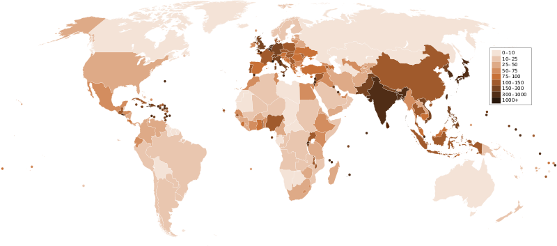
پرونده:Countries by population density.svg

حجم پیشنمایش PNG این SVG file:۸۰۰ × ۳۵۳ پیکسل کیفیتهای دیگر: ۳۲۰ × ۱۴۱ پیکسل | ۶۴۰ × ۲۸۲ پیکسل | ۱٬۰۲۴ × ۴۵۲ پیکسل | ۱٬۲۸۰ × ۵۶۵ پیکسل | ۲٬۵۶۰ × ۱٬۱۲۹ پیکسل | ۶٬۰۰۰ × ۲٬۶۴۷ پیکسل.
پروندهٔ اصلی (پروندهٔ اسویجی، با ابعاد ۶٬۰۰۰ × ۲٬۶۴۷ پیکسل، اندازهٔ پرونده: ۱٫۶۲ مگابایت)
تاریخچهٔ پرونده
روی تاریخ/زمانها کلیک کنید تا نسخهٔ مربوط به آن هنگام را ببینید.
| تاریخ/زمان | بندانگشتی | ابعاد | کاربر | توضیح | |
|---|---|---|---|---|---|
| کنونی | ۲۱ دسامبر ۲۰۱۱، ساعت ۲۳:۳۳ |  | ۶٬۰۰۰ در ۲٬۶۴۷ (۱٫۶۲ مگابایت) | Quibik | added transparency |
| ۲۰ فوریهٔ ۲۰۱۱، ساعت ۱۳:۴۳ |  | ۶٬۰۰۰ در ۲٬۶۴۷ (۱٫۶۲ مگابایت) | Erik del Toro Streb | typographically corrected | |
| ۷ ژانویهٔ ۲۰۰۸، ساعت ۰۲:۲۲ |  | ۶٬۰۰۰ در ۲٬۶۴۷ (۱٫۶۲ مگابایت) | Briefplan~commonswiki | {{Information |Description=A map of the world, with colours to highlight the population density of each country or territory. Numbers on the legend are in people per km<sup>2</sup>, and all countries smaller than 20,000 km<sup>2</sup> are represented by a |
کاربرد پرونده
این پرونده در هیچ صفحهای به کار نرفته است.
کاربرد سراسری پرونده
ویکیهای دیگر زیر از این پرونده استفاده میکنند:
- کاربرد در af.wikipedia.org
- کاربرد در ar.wikipedia.org
- کاربرد در arz.wikipedia.org
- کاربرد در ast.wikipedia.org
- کاربرد در av.wikipedia.org
- کاربرد در awa.wikipedia.org
- کاربرد در azb.wikipedia.org
- کاربرد در az.wikipedia.org
- کاربرد در ba.wikipedia.org
- کاربرد در be.wikipedia.org
- کاربرد در bg.wikipedia.org
- کاربرد در bs.wikipedia.org
- کاربرد در ca.wikipedia.org
- کاربرد در ckb.wikipedia.org
- کاربرد در cs.wikipedia.org
- کاربرد در cy.wikipedia.org
- کاربرد در de.wikipedia.org
- کاربرد در de.wikiversity.org
- کاربرد در diq.wikipedia.org
- کاربرد در dsb.wikipedia.org
- کاربرد در en.wikipedia.org
- کاربرد در eo.wikipedia.org
- کاربرد در es.wikipedia.org
- کاربرد در eu.wikipedia.org
- کاربرد در fi.wikipedia.org
- کاربرد در fr.wikipedia.org
نمایش استفادههای سراسری از این پرونده.
