
پرونده:Babylon 1829 cropped.gif
Babylon_1829_cropped.gif (۴۸۹ × ۳۵۶ پیکسل، اندازهٔ پرونده: ۷۵ کیلوبایت، نوع MIME پرونده: image/gif)
این پرونده در ویکیانبار موجود است. محتویات صفحهٔ توصیف آن در زیر نمایش داده میشود. |
| توضیح |
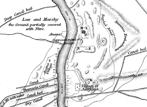
English: Map of the site of Babylon prior to its excavation later in the 19th century. |
| تاریخ | (UTC) |
| منبع |
|
| پدیدآور |
|
| این یک عکس دستکاری شده است به این معنی که به صورت دیجیتالی از نسخهٔ اصلی تغییر یافتهاست. تغییرها: Cropped to show southern area, highlighting the Jumjuma mound. اصل آن را میتوان در اینجا مشاهده کرد: Babylon 1829.jpg. تغییرها توسط ChrisO انجام شدهاست.
|
|
این اثر در کشورهایی و مناطقی که مدت زمان حق تکثیر، عمر پدیدآورنده بعلاوه 70 سال یا کمتر بعد از مرگ او است، در مالکیت عمومی قرار دارد.
| |
| این پرونده تحت قانون حق تکثیر محدودیت آزاد منتشر شده که شامل تمامی حقوق مربوطه و حقوق نزدیک به آن میشود. | |
سیاهه بارگذاری اصلی
This image is a derivative work of the following images:
- File:Babylon_1829.jpg licensed with PD-old
- 2010-06-06T22:50:24Z ChrisO 1065x1464 (228517 Bytes) {{Information |Description={{en|1=Map of the site of Babylon prior to its excavation later in the 19th century.}} |Source=Ground Plan of the Remains at & near Babylon |Author=Captain R. Mignan |Date=October 1829 |Permission=
Uploaded with derivativeFX
تاریخچهٔ پرونده
روی تاریخ/زمانها کلیک کنید تا نسخهٔ مربوط به آن هنگام را ببینید.
| تاریخ/زمان | بندانگشتی | ابعاد | کاربر | توضیح | |
|---|---|---|---|---|---|
| کنونی | ۱۶ ژوئن ۲۰۱۰، ساعت ۲۰:۵۶ | | ۴۸۹ در ۳۵۶ (۷۵ کیلوبایت) | ChrisO | |
| ۶ ژوئن ۲۰۱۰، ساعت ۲۳:۰۷ |  | ۴۸۹ در ۳۵۶ (۸۸ کیلوبایت) | ChrisO | {{Information |Description={{en|1=Map of the site of Babylon prior to its excavation later in the 19th century.}} |Source=*File:Babylon_1829.jpg |Date=2010-06-06 23:07 (UTC) |Author=*File:Babylon_1829.jpg: Captain R. Mignan *derivative work: ~ |
کاربرد پرونده
صفحهٔ زیر از این تصویر استفاده میکند:
کاربرد سراسری پرونده
ویکیهای دیگر زیر از این پرونده استفاده میکنند:
- کاربرد در ar.wikipedia.org
- کاربرد در bn.wikipedia.org
- کاربرد در en.wikipedia.org
- کاربرد در es.wikipedia.org
- کاربرد در fr.wikipedia.org
- کاربرد در he.wikipedia.org
- کاربرد در hyw.wikipedia.org
- کاربرد در no.wikipedia.org
- کاربرد در uk.wikipedia.org