پرونده:Arab population israel 2000 en.png
Page contents not supported in other languages.
از ویکی‌پدیا، دانشنامهٔ آزاد

پروندهٔ اصلی(۶۹۲ × ۱٬۵۷۵ پیکسل، اندازهٔ پرونده: ۱۸۲ کیلوبایت، نوع MIME پرونده: image/png)

خلاصه

توضیح
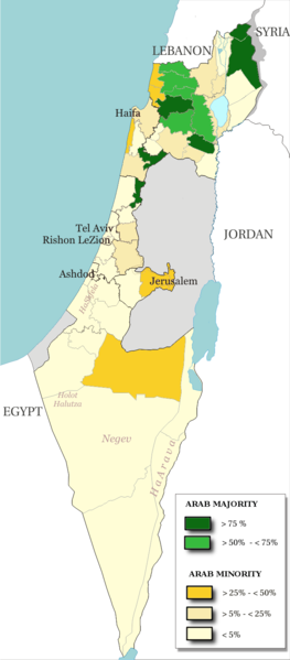
English: Map of the officials 50 "natural regions" of Israel, with their proportions of arab population. The map includ the Golan heights and east Jerusalem, two areas annexed by Israel, annexions not recognize by UNO. The map is based on the demographic situation 2000, and is based upon the arab population in Israel [PDF], a publication (Statistilite N°27) of the israeli Center Bureau of Statistics (CBS) diffused in november 2002.
Français : Carte des 50 "régions naturelles" officiellement reconnues par l'état, subdivision des 15 sous-districts, avec la proportion de population arabe. Cette carte inclue Jérusalem-Est et le plateau du Golan, tous deux annexés par Israël, mais dont l'annexion n'est pas reconnue par l'ONU. La carte est basée sur la situation de la population en l'an 2000, et est inspirée de the arab population in Israel [PDF], une publication (Statistilite N°27) du Center Bureau of Statistics israélien (CBS) diffusée en novembre 2002.
تاریخ
منبع Own work, derivative work of: File:Israel population density.png
پدیدآور Christophe cagé
دیگر نسخه‌ها File:Arabe population israel 2000 fr.png

اجازه‌نامه

© دارندهٔ حق‌تکثیر این پرونده، Israel Central Bureau of Statistics، به هر کسی اجازهٔ استفاده از آن را به هر منظوری می‌دهد، به شرط آنکه به شکلی مناسب به دارندهٔ حق‌تکثیر آن نسبت داده شود. توزیع مجدد، آثار مشتق‌شده، استفادهٔ تجاری، و تمام استفاده‌های دیگر مجاز است.
انتساب:
The Central Bureau of Statistics (CBS), {{{filename}}}, ({{{access-date}}}), [{{{link}}} available online] copied and distributed as is in accordance with the CBS license.

{{{template}}} According to the CBS license, you may not make the following use of the Information, whether by positive act or by omission:
  • present the Information in a misleading manner;
  • present the Information in a way that suggests that the Central Bureau of Statistics, or the State of Israel, supports or endorses you or your use of the Information;
  • make use of the Information in a manner that breaches any applicable law;
  • make use of the Information in a manner that infringes a person's privacy, including merging the Information with other sources of information with the intent of attempting to identify any individual person, business or organization;
  • present the Information in such a manner that gives the appearance that you may have received, or had access to, information held by the Office about any identifiable individual person, business or organization.
من، صاحب حقوق قانونی این اثر، به این وسیله این اثر را تحث اجازه‌نامه‌های ذیل منتشر می‌کنم:
GNU head اجازهٔ کپی، پخش و/یا تغییر این سند تحت شرایط مجوز مستندات آزاد گنو، نسخهٔ ۱٫۲ یا هر نسخهٔ بعدتری که توسط بنیاد نرم‌افزار آزاد منتشر شده؛ بدون بخش‌های ناوردا (نامتغیر)، متون روی جلد، و متون پشت جلد، اعطا می‌شود. یک کپی از مجوز در بخشی تحت عنوان مجوز مستندات آزاد گنو ضمیمه شده است.
w:fa:کرییتیو کامنز
انتساب انتشار مشابه
این پرونده با اجازه‌نامهٔ کریتیو کامانز Attribution-Share Alike 3.0 سازگار نشده، 2.5 عمومی، 2.0 عمومی و 1.0 عمومی منتشر شده است.
شما اجازه دارید:
  • برای به اشتراک گذاشتن – برای کپی، توزیع و انتقال اثر
  • تلفیق کردن – برای انطباق اثر
تحت شرایط زیر:
  • انتساب – شما باید اعتبار مربوطه را به دست آورید، پیوندی به مجوز ارائه دهید و نشان دهید که آیا تغییرات ایجاد شده‌اند یا خیر. شما ممکن است این کار را به هر روش منطقی انجام دهید، اما نه به هر شیوه‌ای که پیشنهاد می‌کند که مجوزدهنده از شما یا استفاده‌تان حمایت کند.
  • انتشار مشابه – اگر این اثر را تلفیق یا تبدیل می‌کنید، یا بر پایه‌ آن اثری دیگر خلق می‌کنید، می‌‌بایست مشارکت‌های خود را تحت مجوز یکسان یا مشابه با ا اصل آن توزیع کنید.
می‌توانید مجوز دلخواه خود را برگزینید.

عنوان

شرحی یک‌خطی از محتوای این فایل اضافه کنید

آیتم‌هایی که در این پرونده نمایش داده شده‌اند

توصیف‌ها

checksum انگلیسی

5afc0b91dfe8d983a85af862f3a58ec981a8a743

۱۸۶٬۱۳۸ بایت

۱٬۵۷۵ پیکسل

۶۹۲ پیکسل

تاریخچهٔ پرونده

روی تاریخ/زمان‌ها کلیک کنید تا نسخهٔ مربوط به آن هنگام را ببینید.

تاریخ/زمانبندانگشتیابعادکاربرتوضیح
کنونی‏۱۵ ژوئیهٔ ۲۰۱۴، ساعت ۱۳:۴۸تصویر بندانگشتی از نسخهٔ مورخ ‏۱۵ ژوئیهٔ ۲۰۱۴، ساعت ۱۳:۴۸۶۹۲ در ۱٬۵۷۵ (۱۸۲ کیلوبایت)Hruska~commonswikiReverted to version as of 08:23, 22 February 2009
‏۱۵ ژوئیهٔ ۲۰۱۴، ساعت ۱۳:۴۷تصویر بندانگشتی از نسخهٔ مورخ ‏۱۵ ژوئیهٔ ۲۰۱۴، ساعت ۱۳:۴۷۶۹۲ در ۱٬۵۷۵ (۱۸۲ کیلوبایت)Hruska~commonswikiReverted to version as of 08:23, 22 February 2009 Revert Edit, The Golan and East Jerusalem de facto Israel, Syria giving Status qo
‏۱۵ ژوئیهٔ ۲۰۱۴، ساعت ۱۳:۴۶تصویر بندانگشتی از نسخهٔ مورخ ‏۱۵ ژوئیهٔ ۲۰۱۴، ساعت ۱۳:۴۶۶۹۲ در ۱٬۵۷۵ (۱۸۲ کیلوبایت)Hruska~commonswikiReverted to version as of 08:23, 22 February 2009
‏۲۱ آوریل ۲۰۰۹، ساعت ۱۵:۳۸تصویر بندانگشتی از نسخهٔ مورخ ‏۲۱ آوریل ۲۰۰۹، ساعت ۱۵:۳۸۶۹۲ در ۱٬۵۷۵ (۱۶۵ کیلوبایت)MeteorMaker~commonswiki{{Information |Description={{en|1=Map of the officials 50 "natural regions" of Israel, with their proportions of arab population. The map includ the Golan heights and east Jerusalem, two areas annexed by Israel, annexions not recognize by UNO. The map is
‏۲۲ فوریهٔ ۲۰۰۹، ساعت ۰۸:۲۳تصویر بندانگشتی از نسخهٔ مورخ ‏۲۲ فوریهٔ ۲۰۰۹، ساعت ۰۸:۲۳۶۹۲ در ۱٬۵۷۵ (۱۸۲ کیلوبایت)Christophe cagé{{Information |Description={{en|1=x}} {{fr|1=x}} |Source=travail personnel (own work) |Author=Christophe cagé |Date=22 february 2009 |Permission=SEE LICENSE |other_versions= }} <!--{{ImageUpload|full}}-->

صفحهٔ زیر از این تصویر استفاده می‌کند:

کاربرد سراسری پرونده

ویکی‌های دیگر زیر از این پرونده استفاده می‌کنند:

فراداده