
پرونده:Zanj Rebellion.svg

حجم پیشنمایش PNG این SVG file:۷۵۰ × ۶۰۰ پیکسل کیفیتهای دیگر: ۳۰۰ × ۲۴۰ پیکسل | ۶۰۰ × ۴۸۰ پیکسل | ۹۶۰ × ۷۶۸ پیکسل | ۱٬۲۸۰ × ۱٬۰۲۴ پیکسل | ۲٬۵۶۰ × ۲٬۰۴۸ پیکسل | ۹۰۰ × ۷۲۰ پیکسل.
پروندهٔ اصلی (پروندهٔ اسویجی، با ابعاد ۹۰۰ × ۷۲۰ پیکسل، اندازهٔ پرونده: ۱٫۲ مگابایت)
این پرونده در ویکیانبار موجود است. محتویات صفحهٔ توصیف آن در زیر نمایش داده میشود. |
خلاصه
| توضیح |
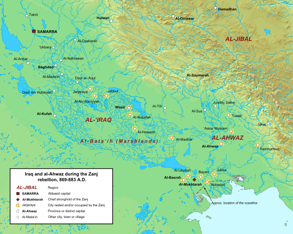
English: Map of the central Abbasid caliphate during the rebellion of the Zanj, from 869 to 883 A.D. All settlements on this map are listed by al-Tabari in his History of the Prophets and Kings, trans. "The History of al-Tabari," volumes 35 through 37. The location of cities and towns that no longer exist were determined using the maps of Le Strange and Popovic in their respective works.
Background topography taken from DEMIS Mapserver, which are public domain. Works Cited:
|
| تاریخ | |
| منبع | اثر شخصی |
| پدیدآور | Ro4444 |
اجازهنامه
من، صاحب حقوق قانونی این اثر، به این وسیله این اثر را تحث اجازهنامهٔ ذیل منتشر میکنم:
این پرونده با اجازهنامهٔ کریتیو کامانز Attribution-Share Alike 3.0 سازگار نشده منتشر شدهاست.
- شما اجازه دارید:
- برای به اشتراک گذاشتن – برای کپی، توزیع و انتقال اثر
- تلفیق کردن – برای انطباق اثر
- تحت شرایط زیر:
- انتساب – شما باید اعتبار مربوطه را به دست آورید، پیوندی به مجوز ارائه دهید و نشان دهید که آیا تغییرات ایجاد شدهاند یا خیر. شما ممکن است این کار را به هر روش منطقی انجام دهید، اما نه به هر شیوهای که پیشنهاد میکند که مجوزدهنده از شما یا استفادهتان حمایت کند.
- انتشار مشابه – اگر این اثر را تلفیق یا تبدیل میکنید، یا بر پایه آن اثری دیگر خلق میکنید، میبایست مشارکتهای خود را تحت مجوز یکسان یا مشابه با ا اصل آن توزیع کنید.
تاریخچهٔ پرونده
روی تاریخ/زمانها کلیک کنید تا نسخهٔ مربوط به آن هنگام را ببینید.
| تاریخ/زمان | بندانگشتی | ابعاد | کاربر | توضیح | |
|---|---|---|---|---|---|
| کنونی | ۱۶ ژوئن ۲۰۱۵، ساعت ۱۴:۴۲ | | ۹۰۰ در ۷۲۰ (۱٫۲ مگابایت) | Ro4444 | Changing location of al-Madhar to 31° 28' 23.4726" N, 47° 23' 4.4982", the location of the burial place of 'Abdallah ibn 'Ali ibn Abi Talib. See M. Streck, "Maisan," ''E.J. Brill's First Encyclopaedia of Islam, Volume V,'' (Leiden: E.J. Brill, 1927),... |
| ۳ مارس ۲۰۱۳، ساعت ۲۱:۱۳ |  | ۹۰۰ در ۷۲۰ (۱٫۲ مگابایت) | Ro4444 | User created page with UploadWizard |
کاربرد پرونده
صفحهٔ زیر از این تصویر استفاده میکند:
کاربرد سراسری پرونده
ویکیهای دیگر زیر از این پرونده استفاده میکنند:
- کاربرد در ar.wikipedia.org
- کاربرد در arz.wikipedia.org
- کاربرد در azb.wikipedia.org
- کاربرد در ca.wikipedia.org
- کاربرد در cy.wikipedia.org
- کاربرد در de.wikipedia.org
- کاربرد در en.wikipedia.org
- کاربرد در es.wikipedia.org
- کاربرد در fr.wikipedia.org
- کاربرد در ga.wikipedia.org
- کاربرد در he.wikipedia.org
- کاربرد در id.wikipedia.org
- کاربرد در ms.wikipedia.org
- کاربرد در pt.wikipedia.org
- کاربرد در sv.wikipedia.org
- کاربرد در tr.wikipedia.org
- کاربرد در www.wikidata.org
- کاربرد در zh.wikipedia.org