
پرونده:Un-kashmir-jammu.png
پروندهٔ اصلی (۲٬۳۰۲ × ۲٬۹۰۱ پیکسل، اندازهٔ پرونده: ۱٫۱ مگابایت، نوع MIME پرونده: image/png)
این پرونده در ویکیانبار موجود است. محتویات صفحهٔ توصیف آن در زیر نمایش داده میشود. |
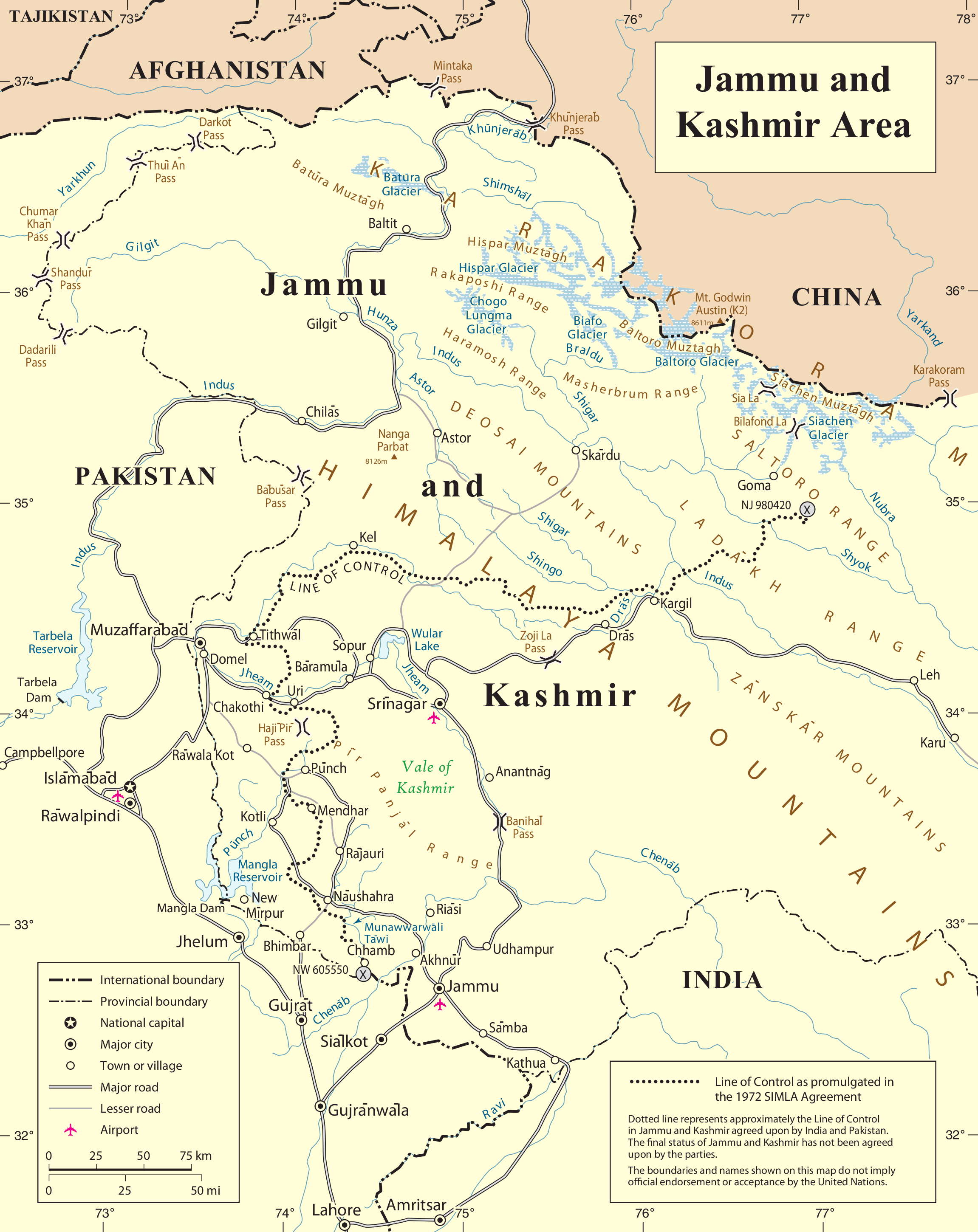
| This image is a map derived from a United Nations map.
Unless stated otherwise, UN maps are to be considered in the public domain. This applies worldwide. UN maps are, in principle, open source material and you can use them in your work or for making your own map. UN requests however that you delete the UN name, logo and reference number upon any modification to the map. Content of your map will be your responsibility. You can state in your publication, if you wish, something like: based on UN map … (map name, map number, revision number and date). See: Geospatial Information Section. And: Geospatial, location data for a better world. |
 |
تاریخچهٔ پرونده
روی تاریخ/زمانها کلیک کنید تا نسخهٔ مربوط به آن هنگام را ببینید.
| تاریخ/زمان | بندانگشتی | ابعاد | کاربر | توضیح | |
|---|---|---|---|---|---|
| کنونی | ۶ ژوئن ۲۰۱۰، ساعت ۲۳:۰۴ | | ۲٬۳۰۲ در ۲٬۹۰۱ (۱٫۱ مگابایت) | Ras67 | cropped |
| ۲۱ اکتبر ۲۰۰۷، ساعت ۲۳:۲۸ |  | ۲٬۳۴۸ در ۲٬۹۴۷ (۱٫۴۷ مگابایت) | Jeroen | {{UN map}} Category:Maps of Kashmir |
کاربرد پرونده
صفحهٔ زیر از این تصویر استفاده میکند:
کاربرد سراسری پرونده
ویکیهای دیگر زیر از این پرونده استفاده میکنند:
- کاربرد در ar.wikipedia.org
- کاربرد در arz.wikipedia.org
- کاربرد در azb.wikipedia.org
- کاربرد در be-tarask.wikipedia.org
- کاربرد در be.wikipedia.org
- کاربرد در bn.wikipedia.org
- کاربرد در ca.wikipedia.org
- کاربرد در ceb.wikipedia.org
- کاربرد در en.wikipedia.org
- Hunza (princely state)
- Line of Control
- Indo-Pakistani war of 1947–1948
- Siachen Glacier
- Yarkand River
- Kashmir conflict
- Saltoro Mountains
- Ghent Kangri
- Nowshera, Jammu and Kashmir
- Siachen conflict
- Bilafond La
- Sia La
- Gyong La
- Siachen Base Camp (India)
- Actual Ground Position Line
- Wikipedia:Graphics Lab/Map workshop/Archive/Aug 2011
- Chumik Glacier
- Saltoro Valley
- User:Falcaorib
- User:Johnleeds1/Kashmir conflict
- کاربرد در es.wikipedia.org
- کاربرد در fr.wikipedia.org
- کاربرد در he.wikipedia.org
نمایش استفادههای سراسری از این پرونده.