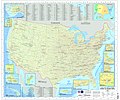
پرونده:U.S. Military Installations Map.jpg

اندازهٔ این پیشنمایش: ۷۱۷ × ۶۰۰ پیکسل. کیفیتهای دیگر: ۲۸۷ × ۲۴۰ پیکسل | ۵۷۴ × ۴۸۰ پیکسل | ۹۱۸ × ۷۶۸ پیکسل | ۱٬۲۲۴ × ۱٬۰۲۴ پیکسل | ۲٬۴۴۹ × ۲٬۰۴۸ پیکسل | ۱۶٬۵۰۰ × ۱۳٬۸۰۰ پیکسل.
پروندهٔ اصلی (۱۶٬۵۰۰ × ۱۳٬۸۰۰ پیکسل، اندازهٔ پرونده: ۵۲٫۳۶ مگابایت، نوع MIME پرونده: image/jpeg)
تاریخچهٔ پرونده
روی تاریخ/زمانها کلیک کنید تا نسخهٔ مربوط به آن هنگام را ببینید.
| تاریخ/زمان | بندانگشتی | ابعاد | کاربر | توضیح | |
|---|---|---|---|---|---|
| کنونی | ۳۰ ژوئن ۲۰۰۹، ساعت ۱۵:۵۱ |  | ۱۶٬۵۰۰ در ۱۳٬۸۰۰ (۵۲٫۳۶ مگابایت) | Sv1xv | {{Information |Description={{en|1=U.S. Military Installations Map (CONUS). This is a map of the major U.S. military installations in the continental United States. It is used by military and government contacts to assist in Federal communication to state |
کاربرد پرونده
صفحهٔ زیر از این تصویر استفاده میکند:
کاربرد سراسری پرونده
ویکیهای دیگر زیر از این پرونده استفاده میکنند:
- کاربرد در en.wikipedia.org
- کاربرد در en.wikiquote.org
- کاربرد در fr.wikipedia.org
- کاربرد در uk.wikipedia.org
- کاربرد در zh.wikipedia.org

