
پرونده:SEQ-councils.png

اندازهٔ این پیشنمایش: ۳۸۴ × ۵۹۹ پیکسل. کیفیتهای دیگر: ۱۵۴ × ۲۴۰ پیکسل | ۳۰۷ × ۴۸۰ پیکسل | ۴۹۲ × ۷۶۸ پیکسل | ۱٬۱۳۱ × ۱٬۷۶۵ پیکسل.
پروندهٔ اصلی (۱٬۱۳۱ × ۱٬۷۶۵ پیکسل، اندازهٔ پرونده: ۴۴۴ کیلوبایت، نوع MIME پرونده: image/png)
این پرونده در ویکیانبار موجود است. محتویات صفحهٔ توصیف آن در زیر نمایش داده میشود. |
خلاصه
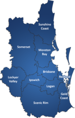
| توضیح | South East Queensland Local Government Areas from 15 March, 2008 |
| تاریخ | |
| منبع | اثر شخصی |
| پدیدآور | MagpieShooter |
اجازهنامه
من، صاحب حقوق قانونی این اثر، به این وسیله این اثر را تحث اجازهنامهٔ ذیل منتشر میکنم:
این پرونده با اجازهنامهٔ کریتیو کامانز Attribution-Share Alike 2.5 استرالیا منتشر شده است.
- شما اجازه دارید:
- برای به اشتراک گذاشتن – برای کپی، توزیع و انتقال اثر
- تلفیق کردن – برای انطباق اثر
- تحت شرایط زیر:
- انتساب – شما باید اعتبار مربوطه را به دست آورید، پیوندی به مجوز ارائه دهید و نشان دهید که آیا تغییرات ایجاد شدهاند یا خیر. شما ممکن است این کار را به هر روش منطقی انجام دهید، اما نه به هر شیوهای که پیشنهاد میکند که مجوزدهنده از شما یا استفادهتان حمایت کند.
- انتشار مشابه – اگر این اثر را تلفیق یا تبدیل میکنید، یا بر پایه آن اثری دیگر خلق میکنید، میبایست مشارکتهای خود را تحت مجوز یکسان یا مشابه با ا اصل آن توزیع کنید.

تاریخچهٔ پرونده
روی تاریخ/زمانها کلیک کنید تا نسخهٔ مربوط به آن هنگام را ببینید.
| تاریخ/زمان | بندانگشتی | ابعاد | کاربر | توضیح | |
|---|---|---|---|---|---|
| کنونی | ۱۹ فوریهٔ ۲۰۰۸، ساعت ۱۲:۴۴ | | ۱٬۱۳۱ در ۱٬۷۶۵ (۴۴۴ کیلوبایت) | MagpieShooter~commonswiki | {{Information |Description=South East Queensland Local Government Areas from 15 March, 2008 |Source=self-made |Date=19th February, 2008 |Author= MagpieShooter |Permission= |other_versions= }} |
کاربرد پرونده
صفحهٔ زیر از این تصویر استفاده میکند:
کاربرد سراسری پرونده
ویکیهای دیگر زیر از این پرونده استفاده میکنند:
- کاربرد در de.wikipedia.org
- کاربرد در en.wikipedia.org
- Wilsons Peak
- South East Queensland
- Greenmount Beach
- Purling Brook Falls
- Bilbrough Falls
- Ephraim Island
- Blackwall, Queensland
- Blue Lake (Queensland)
- Schulz Canal
- Biggera Creek Dam
- Wanora, Queensland
- Coolana, Queensland
- Camp Columbia (Wacol)
- Jeebropilly Mine
- Austinville, Queensland
- Mount Nimmel
- Coomera Falls
- Morans Falls
- Yarrbilgong Falls
- Elabana Falls
- 2008 Queensland storms
- Little Liverpool Range
- Mount Maroon
- Lyons, Queensland
- Mount Cooroora
- Meldale, Queensland
- Cedarton
- Campbells Pocket, Queensland
- Kianawah Park
- Kairabah, Queensland
- Ellinjaa Falls
- Split Yard Creek, Queensland
- Kentville, Queensland
- Elaman Creek, Queensland
- Lake Clarendon, Queensland
- Mount Tarampa, Queensland
- College View, Queensland
- Lower Cressbrook, Queensland
- Derrymore, Queensland
- Morton Vale, Queensland
- Stockyard, Queensland (Lockyer Valley)
- Woodlands, Queensland
- Spring Creek, Queensland (Lockyer Valley Region)
- Reesville, Queensland
- Towen Mountain, Queensland
- Avoca Vale
- Woodbine, Queensland
- Vinegar Hill, Queensland
نمایش استفادههای سراسری از این پرونده.