
پرونده:PIA16577-MarsCuriosityRover-TravelMap-20121130.jpg

پروندهٔ اصلی (۳٬۳۰۰ × ۲٬۵۵۰ پیکسل، اندازهٔ پرونده: ۱٫۸۱ مگابایت، نوع MIME پرونده: image/jpeg)
این پرونده در ویکیانبار موجود است. محتویات صفحهٔ توصیف آن در زیر نمایش داده میشود. |
خلاصه
| توضیح |
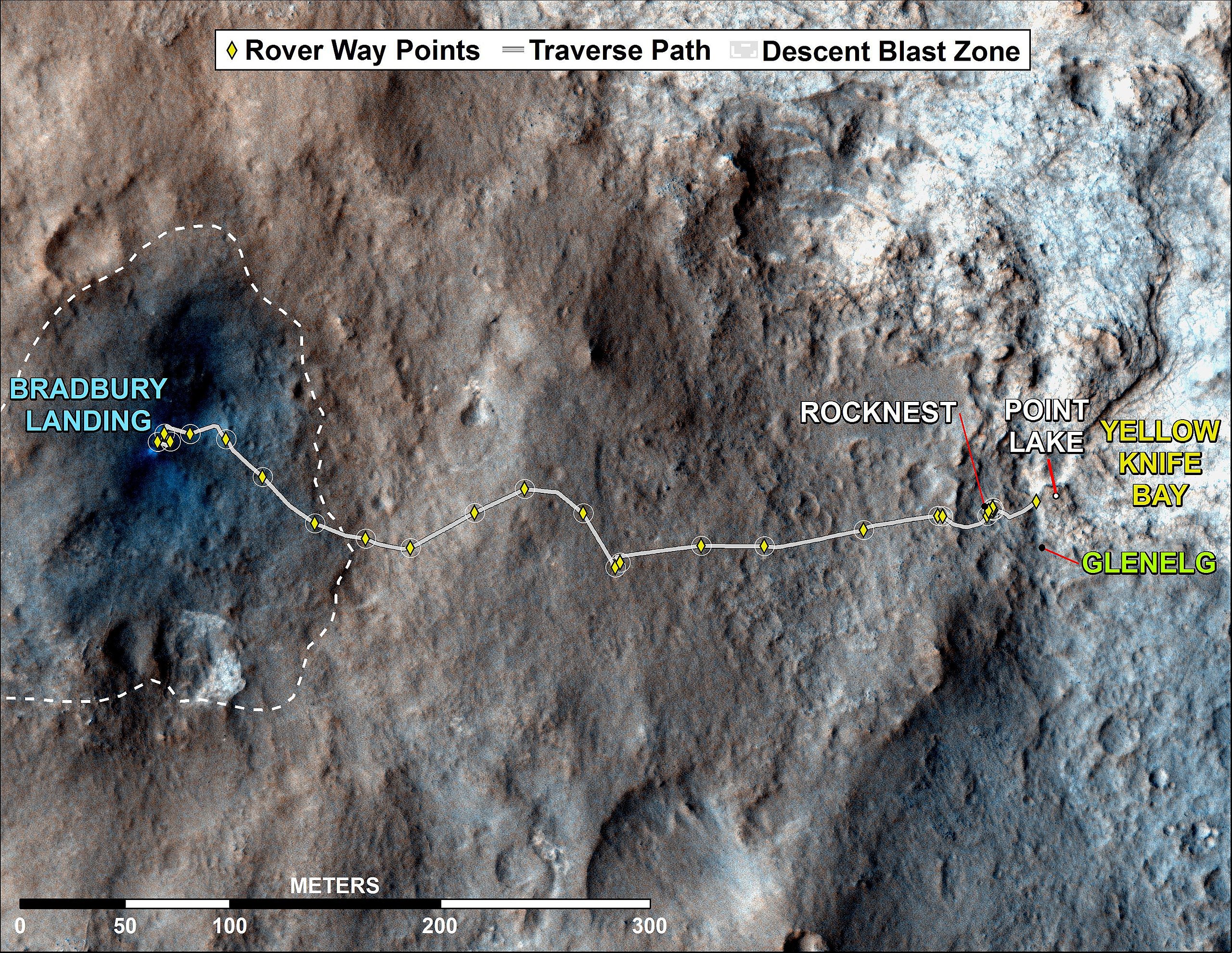
English: PIA16577: Curiosity Rover's Traverse, August through November 2012
http://photojournal.jpl.nasa.gov/catalog/PIA16577 Target Name: Mars Is a satellite of: Sol (our sun) Mission: Mars Reconnaissance Orbiter (MRO) Mars Science Laboratory (MSL) Spacecraft: Curiosity Mars Reconnaissance Orbiter (MRO) Instrument: HiRISE Product Size: 3300 x 2550 pixels (width x height) Produced By: University of Arizona/HiRise-LPL Full-Res TIFF: PIA16577.tif (25.26 MB) Full-Res JPEG: PIA16577.jpg (1.893 MB) Click on the image above to download a moderately sized image in JPEG format (possibly reduced in size from original) Original Caption Released with Image: This map shows where NASA's Mars rover Curiosity has driven since landing at a site subsequently named "Bradbury Landing," and traveling to an overlook position near beside "Point Lake," in drives totaling 1,703 feet (519 meters). The rover landed on Aug. 5 Pacific Time (Aug. 6, Universal Time). It was at the easternmost waypoint on this map on Nov. 30, 2012. It worked on scoops of soil for a few weeks at the drift of windblown sand called "Rocknest." The place called "Glenelg" is where three types of terrain meet. The depression called "Yellowknife Bay" is a potential location for selecting the first target rock for Curiosity's hammering drill. All of these sites are within Gale Crater and north of the mountain called Mount Sharp in the middle of the crater. After using its drill in the Glenelg area, the rover's main science destination will be on the lower reaches of Mount Sharp. For broader-context images of the area, see PIA16064 and PIA16058. The base image from the map is from the High Resolution Imaging Science Experiment Camera (HiRISE) in NASA's Mars Reconnaissance Orbiter. JPL manages the Mars Science Laboratory/Curiosity for NASA's Science Mission Directorate in Washington. The rover was designed, developed and assembled at JPL, a division of the California Institute of Technology in Pasadena. For more about NASA's Curiosity mission, visit: http://www.jpl.nasa.gov/msl, http://www.nasa.gov/mars, and http://mars.jpl.nasa.gov/msl. Image Credit: NASA/JPL-Caltech/Univ. of Arizona Image Addition Date: 2012-12-03Polski: Mapa ta pokazuje trasę przebytą przez należący do NASA łazik Curiosity od miejsca lądowania, później nazwanego "Bradbury Landing", obok miejsca "Lake Point" do obszaru "Glenelg", w sumie przebywając 519 metrów. Łazik wylądował 5 sierpnia czasu pacyficznego (6 sierpnia, Universal Time). 30 listopada 2012 łazik był na najbardziej wysuniętym na wschód punkcie na tej mapie. Pracował używając czerpaka łopatki kopiąc przez kilka tygodni na zboczu wydmy w miejscu zwanym "Rocknest". Na obszarze zwanym "Glenelg" występują trzy rodzaje terenu. Depresja nazywana "Yellowknife Bay" jest miejscem na wybranie pierwszej skały docelowej do użycia wiertarki. Miejsce to zostało nazwane "John Klein". Wszystkie opisane na mapie miejsca znajdują się w kraterze Gale, na północ od góry zwanej Góra Sharp znajdującej się w środku krateru. Po pracach z użyciem wiertarki na obszarze Glenelg, głównym celem podróży łazika będą niższe tereny Mount Sharp. Aby zobaczyć okolicę w szerszym kontekście, zobacz: PIA16064 i PIA16058. |
| تاریخ | |
| منبع | http://photojournal.jpl.nasa.gov/jpeg/PIA16577.jpg |
| پدیدآور | NASA/JPL-Caltech/Univ. of Arizona |
اجازهنامه
| این پرونده در مالکیت عمومی قرار دارد چرا که توسط ناسا ایجاد شده است. سیاست حق تکثیر ناسا بیان میکند که «مواد ناسا با حق تکثیر محافظت نمیشوند، مگراینکه ذکر شده باشد». (Template:PD-USGov، صفحهٔ سیاست حق تکثیر ناسا یا سیاست جیپیال استفاده از تصاویر را ببینید.) | ||
 |
هشدارها:
|
تاریخچهٔ پرونده
روی تاریخ/زمانها کلیک کنید تا نسخهٔ مربوط به آن هنگام را ببینید.
| تاریخ/زمان | بندانگشتی | ابعاد | کاربر | توضیح | |
|---|---|---|---|---|---|
| کنونی | ۳ دسامبر ۲۰۱۲، ساعت ۱۸:۴۴ | | ۳٬۳۰۰ در ۲٬۵۵۰ (۱٫۸۱ مگابایت) | Drbogdan | User created page with UploadWizard |
کاربرد پرونده
صفحهٔ زیر از این تصویر استفاده میکند:
کاربرد سراسری پرونده
ویکیهای دیگر زیر از این پرونده استفاده میکنند:
- کاربرد در pl.wikipedia.org