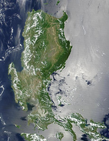
پرونده:Northern Philippines (Luzon).jpg

اندازهٔ این پیشنمایش: ۴۶۱ × ۵۹۹ پیکسل. کیفیتهای دیگر: ۱۸۴ × ۲۴۰ پیکسل | ۳۶۹ × ۴۸۰ پیکسل | ۵۹۱ × ۷۶۸ پیکسل | ۷۸۸ × ۱٬۰۲۴ پیکسل | ۲٬۰۰۰ × ۲٬۶۰۰ پیکسل.
پروندهٔ اصلی (۲٬۰۰۰ × ۲٬۶۰۰ پیکسل، اندازهٔ پرونده: ۷۳۸ کیلوبایت، نوع MIME پرونده: image/jpeg)
تاریخچهٔ پرونده
روی تاریخ/زمانها کلیک کنید تا نسخهٔ مربوط به آن هنگام را ببینید.
| تاریخ/زمان | بندانگشتی | ابعاد | کاربر | توضیح | |
|---|---|---|---|---|---|
| کنونی | ۲۵ اکتبر ۲۰۰۵، ساعت ۲۱:۵۲ |  | ۲٬۰۰۰ در ۲٬۶۰۰ (۷۳۸ کیلوبایت) | Brian0918 | * Credit Jacques Descloitres, MODIS Land Rapid Response Team, NASA/GSFC This MODIS true-color image of the northern Philippines shows the island of Luzon and the Cagayan River running in the plains between the Sierra Madre mountain rang |
کاربرد پرونده
صفحهٔ زیر از این تصویر استفاده میکند:
کاربرد سراسری پرونده
ویکیهای دیگر زیر از این پرونده استفاده میکنند:
- کاربرد در af.wikipedia.org
- کاربرد در ar.wikipedia.org
- کاربرد در arz.wikipedia.org
- کاربرد در ast.wikipedia.org
- کاربرد در ba.wikipedia.org
- کاربرد در be-tarask.wikipedia.org
- کاربرد در be.wikipedia.org
- کاربرد در bg.wikipedia.org
- کاربرد در bjn.wikipedia.org
- کاربرد در bo.wikipedia.org
- کاربرد در ca.wikipedia.org
- کاربرد در cy.wikipedia.org
- کاربرد در de.wikipedia.org
- کاربرد در el.wikipedia.org
- کاربرد در en.wikipedia.org
- کاربرد در eo.wikipedia.org
- کاربرد در es.wikipedia.org
- کاربرد در et.wikipedia.org
- کاربرد در eu.wikipedia.org
- کاربرد در fi.wiktionary.org
- کاربرد در fr.wikipedia.org
- کاربرد در fr.wikivoyage.org
- کاربرد در ga.wikipedia.org
- کاربرد در he.wikipedia.org
- کاربرد در hu.wikipedia.org
- کاربرد در hy.wikipedia.org
- کاربرد در ia.wikipedia.org
- کاربرد در id.wikipedia.org
- کاربرد در id.wiktionary.org
- کاربرد در incubator.wikimedia.org
- کاربرد در jv.wikipedia.org
- کاربرد در ka.wikipedia.org
- کاربرد در ky.wikipedia.org
- کاربرد در lv.wikipedia.org
- کاربرد در ms.wikipedia.org
- کاربرد در nn.wikipedia.org
- کاربرد در os.wikipedia.org
- کاربرد در pl.wikipedia.org
نمایش استفادههای سراسری از این پرونده.


