
پرونده:MPK1-426 Sykes Picot Agreement Map signed 8 May 1916.jpg
پروندهٔ اصلی (۳٬۳۲۲ × ۳٬۲۲۵ پیکسل، اندازهٔ پرونده: ۵٫۷ مگابایت، نوع MIME پرونده: image/jpeg)
این پرونده در ویکیانبار موجود است. محتویات صفحهٔ توصیف آن در زیر نمایش داده میشود. |
خلاصه
| Description |
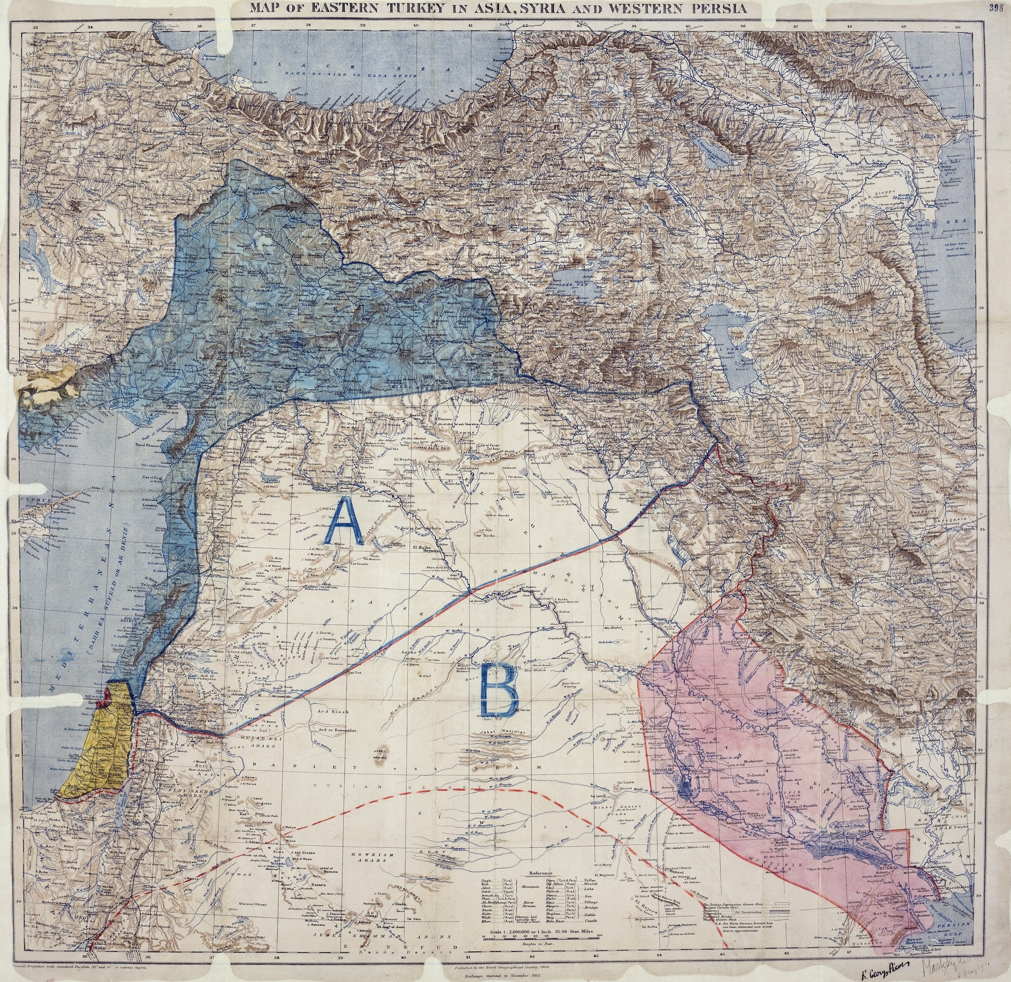
العربية: خريطة اتفاقية سايكس بيكو تُظهر شرق تُركيا في آسيا وسوريا وغرب بلاد فارس ومناطق نفوذ البريطانيين والفرنسيين المُتَّفق عليها. الجمعية الجغرافية الملكية، 15-1910. وقعها مارك سايكس و فرانسوا جورج بيكو، 8 مايو 1916.
English: Map of showing Eastern Turkey in Asia, Syria and Western Persia, and areas of control and influence agreed between the British and the French. Royal Geographical Society, 1910-15. Signed by Mark Sykes and François Georges-Picot, 8 May 1916.
Français : Carte des Accords Sykes-Picot montrant la Turquie orientale en Asie, Syrie et Perse occidentale, ainsi que les zones de contrôle et d'influence convenues entre la France et le Royaume-Uni. Royal Geographical Society, 1910-15. Signés par Mark Sykes et François Georges-Picot, le 8 Mai 1916.
Kurdî: Nexşeya Peymana Sykes–Picot li Asyayê, rojhilatê Tirkiyeyê, Sûrî û rojavayê Îranê û herêmên di bin serwerî û bandora Brîtanya û Fransa de nîşan dide. Ji aliyê Royal Geographical Society ve, 1910-15 hatiye çêkirin. Ji aliyê Mark Sykes û François Georges-Picot ve hatiye îmzekirin, 8 gulan 1916
Português: Mapa do Acordo Sykes-Picot mostrando a Turquia Oriental na Ásia, a Síria e Pérsia Ocidental e áreas de controle e influência definidas pelos britânicos e os franceses. Real Sociedade Geográfica, 1910-15. Assinado por Mark Sykes e François Georges-Picot, 8 de maio de 1916.
Türkçe: Sykes-Picot Anlaşması kapsamında Fransız ve İngiliz etkisi ve kontrol alanları, Türkiye'nin doğusunda Suriye ve Batı İran bir harita gösterilmektedir.Kraliyet Coğrafya Kurumu, 1910-15. Mark Sykes ve François Georges-Picot imzaları, 8 Mayıs 1916. |
||
| تاریخ | |||
| منبع |
|
||
| پدیدآورنده | |||
| Georeferencing | If inappropriate please set warp_status = skip to hide. | ||
| دیگر نسخهها |
_on_8_May_1916_-_(cropped).jpg)
_on_8_May_1916_(cropped).jpg)
|
اجازهنامه
این اثر در ایالات متحده آمریکا در مالکیت عمومی قرار دارد به این دلیل که قبل از ۱ ژانویهٔ ۱۹۲۹ منتشر یا در ادارهٔ حق تکثیر آمریکا ثبت شدهاست.
آثار ماکلیت عمومی میبایست خارج از حق تکثیر هم در آمریکا و هم در کشور مبدأ اثر باشند تا بتوانند در ویکیانبار قرار بگیرند. اگر اثر، اثر ایالات متحده آمریکا نباشد، پرونده میبایست یک برچسپ حق تکثیر اضافی داشته باشند که وضعیت حق تکثیر را در کشور مبدأ مشخص کند.
|
This work created by the United Kingdom Government is in the public domain.
This is because it is one of the following:
HMSO has declared that the expiry of Crown Copyrights applies worldwide (ref: HMSO Email Reply)
|
 |
تاریخچهٔ پرونده
روی تاریخ/زمانها کلیک کنید تا نسخهٔ مربوط به آن هنگام را ببینید.
| تاریخ/زمان | بندانگشتی | ابعاد | کاربر | توضیح | |
|---|---|---|---|---|---|
| کنونی | ۱۶ مهٔ ۲۰۱۷، ساعت ۰۳:۵۸ | | ۳٬۳۲۲ در ۳٬۲۲۵ (۵٫۷ مگابایت) | PawełMM | Cropped 8 % horizontally and 2 % vertically using CropTool with lossless mode. |
| ۱۲ اکتبر ۲۰۱۱، ساعت ۰۷:۰۱ |  | ۳٬۶۰۰ در ۳٬۲۹۳ (۵٫۹ مگابایت) | Gavin.collins |
کاربرد پرونده
صفحههای زیر از این تصویر استفاده میکنند:
کاربرد سراسری پرونده
ویکیهای دیگر زیر از این پرونده استفاده میکنند:
- کاربرد در ar.wikipedia.org
- وعد بلفور
- مراسلات الحسين – مكماهون
- اتفاقية سايكس بيكو
- بوابة:محتوى متميز
- ويكيبيديا:صور مختارة
- ويكيبيديا:صور مختارة/رسومات وجداول وخرائط
- بوابة:الوطن العربي/صورة مختارة/أرشيف
- ويكيبيديا:صور مختارة/رسومات وجداول وخرائط/خرائط
- بوابة:محتوى متميز/محتويات
- بوابة:محتوى متميز/محتويات/صور مختارة
- بوابة:محتوى متميز/الرئيسية
- الانتداب البريطاني على فلسطين (صك قانوني)
- احتلال معان
- التسوية الإنجليزية الفرنسية المؤقتة 1918
- ويكيبيديا:ترشيحات الصور المختارة/خريطة اتفاقية سايكس بيكو
- ويكيبيديا:صورة اليوم المختارة/أكتوبر 2023
- قالب:صورة اليوم المختارة/2023-10-29
- بوابة:الوطن العربي/صورة مختارة/143
- کاربرد در arz.wikipedia.org
- کاربرد در ast.wikipedia.org
- کاربرد در az.wikipedia.org
- کاربرد در bn.wikipedia.org
- کاربرد در ca.wikipedia.org
- کاربرد در ckb.wikipedia.org
- کاربرد در cy.wikipedia.org
- کاربرد در de.wikipedia.org
- کاربرد در el.wikipedia.org
- کاربرد در en.wikipedia.org
- Arabs
- Balfour Declaration
- Emirate of Transjordan
- Sykes–Picot Agreement
- Great Syrian Revolt
- Grease pencil
- Golan Heights
- Mandate for Palestine
- User:Chickstarr404/Gather lists/14627 – Personal History - Desert Gardens by Vincent Sheehan
- Wikipedia:Graphics Lab/Photography workshop/Archive/Jun 2017
- 1918 Anglo-French Modus Vivendi
- Occupation of Ma'an
- User:Free Syrian 200/الثورة السورية الكبرى
- User:Falcaorib
- User:Lou Löwe/sandbox
- Rashid Rida during World War I
- User:Sarah SchneiderCH/sandbox2
- کاربرد در eo.wikipedia.org
- کاربرد در es.wikipedia.org
- کاربرد در fi.wikipedia.org
نمایش استفادههای سراسری از این پرونده.