
پرونده:Italian-social-republic-and-civil-war.svg

پروندهٔ اصلی (پروندهٔ اسویجی، با ابعاد ۱٬۰۰۰ × ۱٬۵۰۰ پیکسل، اندازهٔ پرونده: ۸۵۰ کیلوبایت)
این پرونده در ویکیانبار موجود است. محتویات صفحهٔ توصیف آن در زیر نمایش داده میشود. |
خلاصه
| توضیح |
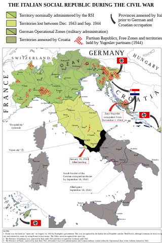
English: Map of Italy during the Civil War, focusing on the Italian Social Republic Italiano: Carta dell'Italia durante la Guerra Civile con particolare attenzione alla Repubblica Sociale Italiana |
| تاریخ | |
| منبع |
اثر شخصی - Bibliography: Atlante storico della Resistenza italiana by L. Baldissara, Bruno Mondadori, 2000; Storia della Guerra Civile in Italia 1943-1945 by Giorgio Pisanò, FPE, 1965-'67; Breve storia della Resistenza Italiana, FIVL, Edizioni Civitas, 1990. About OZAK: Salò-Berlino, l'alleanza difficile by Nicola Cospito, Hans W. Neulen, Mursia and this map; about Rome "open city" occupied by Germans and not capital of RSI, Renzo De Felice, Mussolini, l'Alleato. La guerra civile, Einaudi, p. 373. About German and Allies positions in Southern Italy at September 18, 1943: http://www.westpoint.edu/, Harper Collins Atlas of the Second World War, Storia della Seconda guerra mondiale, vol. 4, Rizzoli-Purnell. About the territories held by Yugoslav partisans in Dalmazia and in the Province of Ljubljana see http://upload.wikimedia.org/wikipedia/commons/f/f8/Oslobo%C4%91ena_teritorija_septembra_1944.jpg . About the British-Yugoslav occupation of Lissa (Vis), see: "Chronology and Index of the Second World War, 1938-1945" (The Royal Institute of International Affairs) and "Tito, Mihailović, and the Allies, 1941-1945" (Walter R. Roberts). About the names of cities see http://images.nationmaster.com/images/motw/historical/italy_1921.jpg Original map realized for the congress “Agricoltura e vita quotidiana nella RSI” (Salò, Italy, October 2004) - new version updated and remedied on Storia in Rete n. 49-50 (released in CC 3.0 SA by). |
| پدیدآور | Emanuele Mastrangelo |
| دیگر نسخهها |
[]
|


اجازهنامه
- شما اجازه دارید:
- برای به اشتراک گذاشتن – برای کپی، توزیع و انتقال اثر
- تلفیق کردن – برای انطباق اثر
- تحت شرایط زیر:
- انتساب – شما باید اعتبار مربوطه را به دست آورید، پیوندی به مجوز ارائه دهید و نشان دهید که آیا تغییرات ایجاد شدهاند یا خیر. شما ممکن است این کار را به هر روش منطقی انجام دهید، اما نه به هر شیوهای که پیشنهاد میکند که مجوزدهنده از شما یا استفادهتان حمایت کند.
- انتشار مشابه – اگر این اثر را تلفیق یا تبدیل میکنید، یا بر پایه آن اثری دیگر خلق میکنید، میبایست مشارکتهای خود را تحت مجوز یکسان یا مشابه با ا اصل آن توزیع کنید.

|
Legal disclaimer This image shows (or resembles) a symbol that was used by the National Socialist (NSDAP/Nazi) government of Germany or an organization closely associated to it, or another party which has been banned by the Federal Constitutional Court of Germany. The use of insignia of organizations that have been banned in Germany (like the Nazi swastika or the arrow cross) may also be illegal in Austria, Hungary, Poland, Czech Republic, France, Brazil, Israel, Ukraine, Russia and other countries, depending on context. In Germany, the applicable law is paragraph 86a of the criminal code (StGB), in Poland – Art. 256 of the criminal code (Dz.U. 1997 nr 88 poz. 553). |
تاریخچهٔ پرونده
روی تاریخ/زمانها کلیک کنید تا نسخهٔ مربوط به آن هنگام را ببینید.
| تاریخ/زمان | بندانگشتی | ابعاد | کاربر | توضیح | |
|---|---|---|---|---|---|
| کنونی | ۸ دسامبر ۲۰۲۱، ساعت ۰۹:۴۸ | | ۱٬۰۰۰ در ۱٬۵۰۰ (۸۵۰ کیلوبایت) | Andrei Stroe | File uploaded using svgtranslate tool (https://svgtranslate.toolforge.org/). Added translation for ro. |
| ۱ آوریل ۲۰۱۵، ساعت ۱۶:۱۸ |  | ۱٬۰۰۰ در ۱٬۵۰۰ (۸۳۲ کیلوبایت) | NikNaks | Reverted to version as of 16:30, 31 March 2015 | |
| ۳۱ مارس ۲۰۱۵، ساعت ۱۷:۲۷ |  | ۱٬۰۰۰ در ۱٬۵۰۰ (۸۰۲ کیلوبایت) | NikNaks | replace fortifications with text Vs | |
| ۳۱ مارس ۲۰۱۵، ساعت ۱۶:۳۰ |  | ۱٬۰۰۰ در ۱٬۵۰۰ (۸۳۲ کیلوبایت) | P. S. Burton | ||
| ۳۱ مارس ۲۰۱۵، ساعت ۱۶:۲۸ |  | ۱٬۰۰۰ در ۱٬۵۰۰ (۸۳۲ کیلوبایت) | P. S. Burton | ||
| ۳۱ مارس ۲۰۱۵، ساعت ۱۶:۲۶ |  | ۱٬۰۰۰ در ۱٬۵۰۰ (۸۳۲ کیلوبایت) | P. S. Burton | trying again | |
| ۳۱ مارس ۲۰۱۵، ساعت ۱۶:۲۲ |  | ۱٬۰۰۰ در ۱٬۵۰۰ (۸۳۲ کیلوبایت) | P. S. Burton | text corrections | |
| ۳۱ مارس ۲۰۱۵، ساعت ۱۵:۵۵ |  | ۱٬۰۰۰ در ۱٬۵۰۰ (۸۳۲ کیلوبایت) | NikNaks | simplified circle pattern | |
| ۳۱ مارس ۲۰۱۵، ساعت ۱۵:۳۰ |  | ۱٬۰۰۰ در ۱٬۵۰۰ (۸۴۰ کیلوبایت) | NikNaks | error in striped area | |
| ۳۰ مارس ۲۰۱۵، ساعت ۲۱:۲۴ |  | ۱٬۰۰۰ در ۱٬۵۰۰ (۸۸۲ کیلوبایت) | NikNaks | size of "FRANCE" fixed |
کاربرد پرونده
صفحههای زیر از این تصویر استفاده میکنند:
کاربرد سراسری پرونده
ویکیهای دیگر زیر از این پرونده استفاده میکنند:
- کاربرد در ar.wikipedia.org
- کاربرد در bg.wikipedia.org
- کاربرد در de.wikipedia.org
- کاربرد در el.wikipedia.org
- کاربرد در en.wikipedia.org
- کاربرد در fr.wikipedia.org
- کاربرد در he.wikipedia.org
- کاربرد در hr.wikipedia.org
- کاربرد در id.wikipedia.org
- کاربرد در it.wikipedia.org
- کاربرد در ja.wikipedia.org
- کاربرد در ko.wikipedia.org
- کاربرد در lv.wikipedia.org
- کاربرد در mk.wikipedia.org
- کاربرد در no.wikipedia.org
- کاربرد در pt.wikipedia.org
- کاربرد در ro.wikipedia.org
- کاربرد در sc.wikipedia.org
- کاربرد در sh.wikipedia.org
- کاربرد در tr.wikipedia.org
- کاربرد در www.wikidata.org
- کاربرد در zh.wikipedia.org