پرونده:Is-wb-gs-gh v3.png
Page contents not supported in other languages.
از ویکی‌پدیا، دانشنامهٔ آزاد

پروندهٔ اصلی(۱٬۴۲۸ × ۲٬۲۸۹ پیکسل، اندازهٔ پرونده: ۲۵۹ کیلوبایت، نوع MIME پرونده: image/png)

خلاصه

توضیح
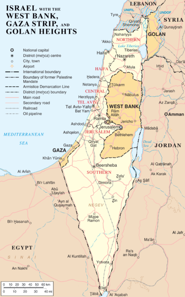
English: Map of Israel, the Palestinian territories (West Bank and Gaza Strip), the Golan Heights, and portions of neighbouring countries. Also United Nations deployment areas in countries adjoining Israel or Israeli-held territory, as of January 2004.
العربية: خريطة إسرائيل والأراضي الفلسطينية (الضفة الغربية وقطاع غزة) ومرتفعات الجولان وأجزاء من الدول المجاورة. وكذلك مناطق انتشار الأمم المتحدة في البلدان المجاورة لإسرائيل أو الأراضي التي تسيطر عليها إسرائيل ، حتى كانون الثاني / يناير 2004.
تاریخ
منبع http://www.un.org/Depts/Cartographic/map/profile/israel.pdf (heavily modified)
پدیدآور ChrisO
دیگر نسخه‌ها

آثار انشقاقی از این پرونده:

File:Map of Israel, neighbours and occupied territories.svg یک نسخهٔ برداری از این پرونده است.
آن پرونده را هنگامی که بهتر بود می‌بایست به جای این نسخهٔ تصویر استفاده کرد.


برای کسب اطلاعات بیشتر در ارتباط با تصاویر برداری لطفاً اینجا را مطالعه‌کنید.
همچنین اطلاعات بیشتری در ارتباط با حمایت مدیاویکی از تصاویر اس‌وی‌جی وجود دارد.

در زبان های دیگر
Alemannisch  Bahasa Indonesia  Bahasa Melayu  British English  català  čeština  dansk  Deutsch  eesti  English  español  Esperanto  euskara  français  Frysk  galego  hrvatski  Ido  italiano  lietuvių  magyar  Nederlands  norsk bokmål  norsk nynorsk  occitan  Plattdüütsch  polski  português  português do Brasil  română  Scots  sicilianu  slovenčina  slovenščina  suomi  svenska  Tiếng Việt  Türkçe  vèneto  Ελληνικά  беларуская (тарашкевіца)  български  македонски  нохчийн  русский  српски / srpski  татарча/tatarça  українська  ქართული  հայերեն  বাংলা  தமிழ்  മലയാളം  ไทย  한국어  日本語  简体中文  繁體中文  עברית  العربية  فارسی  +/−
New SVG image

اجازه‌نامه

Public domain این اثر توسط پدیدآور آن، ChrisO در ویکی‌پدیا انگلیسی، به مالکیت عمومی درآمده است. این مربوط به تمام جهان است.
در برخی از کشورها ممکن است به صورت قانونی این امکان‌پذیر نباشد؛ اگر چنین است:
ChrisO به هر کسی اجازهٔ استفاده از این اثر برای هر مقصودی، بدون هیچ‌گونه شرایطی، را می‌دهد تا وقتی که این شرایط توسط قانون مستلزم نشده باشند.
Public domain This image is a map derived from a United Nations map.

Unless stated otherwise, UN maps are to be considered in the public domain. This applies worldwide.
Some UN maps have special copyrights, as indicated on the map itself.

UN maps are, in principle, open source material and you can use them in your work or for making your own map. UN requests however that you delete the UN name, logo and reference number upon any modification to the map. Content of your map will be your responsibility. You can state in your publication, if you wish, something like: based on UN map … (map name, map number, revision number and date). See: Geospatial Information Section. And: Geospatial, location data for a better world.

سیاهه بارگذاری اصلی

صفحهٔ اصلی توضیحات اینجابود. همهٔ نام‌های کاربر زیر به en.wikipedia اشاره دارند.
  • 2007-04-03 22:53 ChrisO 1428×2289×8 (264824 bytes) == Summary == {{Information |Description= {{en|Map of [[Israel]], the [http://en.wikipedia.org/wiki/Palestinian_territories Palestinian territories] ([[West Bank]] and [[Gaza Strip]]), the [[Golan Heights]], and portions of neighbouring countries. Also [[

عنوان

شرحی یک‌خطی از محتوای این فایل اضافه کنید

آیتم‌هایی که در این پرونده نمایش داده شده‌اند

توصیف‌ها

تاریخچهٔ پرونده

روی تاریخ/زمان‌ها کلیک کنید تا نسخهٔ مربوط به آن هنگام را ببینید.

تاریخ/زمانبندانگشتیابعادکاربرتوضیح
کنونی‏۱۲ مارس ۲۰۱۲، ساعت ۱۰:۵۴تصویر بندانگشتی از نسخهٔ مورخ ‏۱۲ مارس ۲۰۱۲، ساعت ۱۰:۵۴۱٬۴۲۸ در ۲٬۲۸۹ (۲۵۹ کیلوبایت)Ayin leZionMarked J'lem as capital according to en:Israel
‏۱۱ آوریل ۲۰۰۷، ساعت ۰۸:۲۲تصویر بندانگشتی از نسخهٔ مورخ ‏۱۱ آوریل ۲۰۰۷، ساعت ۰۸:۲۲۱٬۴۲۸ در ۲٬۲۸۹ (۲۵۹ کیلوبایت)Liftarn{{Information |Description=Map of Israel, the Palestinian territories (West Bank and Gaza Strip), the Golan Heights, and portions of neighbouring countries. Also United Nations deployment areas in countries adjoining Israel or Israeli-held territory, as o

صفحه‌های زیر از این تصویر استفاده می‌کنند:

کاربرد سراسری پرونده

ویکی‌های دیگر زیر از این پرونده استفاده می‌کنند:

نمایش استفاده‌های سراسری از این پرونده.

فراداده