
پرونده:Irene Aug 24 2011 1810Z.jpg

پروندهٔ اصلی (۶٬۴۰۰ × ۸٬۲۰۰ پیکسل، اندازهٔ پرونده: ۲۵٫۴۸ مگابایت، نوع MIME پرونده: image/jpeg)
این پرونده در ویکیانبار موجود است. محتویات صفحهٔ توصیف آن در زیر نمایش داده میشود. |
| هشدار | بعضی از مرورگرها با نمایش این تصویر با وضوح تصویر بالا مشکل دارند: این تصویر تعداد زیادی نقطه دارد و ممکن است به درستی در مرورگر شما بارگیری نشود یا باعث متوقف شدن مرورگر شما شود. |
|---|
خلاصه
| توضیح |
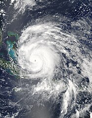
English: Hurricane Irene strengthened on its path toward the continental United States in late August 2011. Residents of the U.S. East Coast braced for the first hurricane to seriously threaten the country in three years, Voice of America reported.
The Moderate Resolution Imaging Spectroradiometer (MODIS) on NASA’s Aqua satellite captured this natural-color image at 2:15 p.m. local time (18:15 UTC) on August 24. Storm clouds hide the Turks and Caicos Islands, and extend westward over The Bahamas. Clouds also linger over the Dominican Republic and Haiti. At 2:00 p.m. Eastern Daylight Time on August 24, about the time MODIS took this picture, the U.S. National Hurricane Center (NHC) reported that Irene was a Category 3 hurricane with maximum sustained winds of 120 miles (195 kilometers) per hour. By 5:00 a.m. EDT on August 25, the NHC reported, Irene’s winds had weakened slightly, to 115 miles (185 kilometers) per hour. The storm remained a powerful Category 3 hurricane. A hurricane warning was in effect for the southeastern, central, and northwestern Bahamas. A hurricane watch was in effect for Surf City, North Carolina, northward to the Virginia border. A tropical storm watch was in effect for Edisto Beach, South Carolina, north to Surf City. As of 5:00 a.m. EDT on August 25, Irene was moving toward the northwest at about 12 miles (19 kilometers) per hour. The storm was expected to turn toward the north-northwest the same day, then toward the north early the following day. The NHC five-day storm track showed Irene moving northward along the U.S. East Coast. As U.S. residents braced for Irene’s arrival, residents of Caribbean Islands cleaned up from the destructive storm. The Christian Science Monitor reported that flooding and mudslides had forced the Dominican Republic to evacuate nearly 38,000 people, and a U.S.-based analysis firm estimated potential damage in the Caribbean at up to $3.1 billion. |
| تاریخ | |
| منبع | http://earthobservatory.nasa.gov/NaturalHazards/view.php?id=51867 |
| پدیدآور | NASA image courtesy Jeff Schmaltz, MODIS Rapid Response, NASA Goddard Space Flight Center. Caption by Michon Scott. |
اجازهنامه
| این پرونده در مالکیت عمومی قرار دارد چرا که توسط ناسا ایجاد شده است. سیاست حق تکثیر ناسا بیان میکند که «مواد ناسا با حق تکثیر محافظت نمیشوند، مگراینکه ذکر شده باشد». (Template:PD-USGov، صفحهٔ سیاست حق تکثیر ناسا یا سیاست جیپیال استفاده از تصاویر را ببینید.) | ||
 |
هشدارها:
|
تاریخچهٔ پرونده
روی تاریخ/زمانها کلیک کنید تا نسخهٔ مربوط به آن هنگام را ببینید.
| تاریخ/زمان | بندانگشتی | ابعاد | کاربر | توضیح | |
|---|---|---|---|---|---|
| کنونی | ۲۹ اکتبر ۲۰۱۹، ساعت ۰۶:۴۹ | | ۶٬۴۰۰ در ۸٬۲۰۰ (۲۵٫۴۸ مگابایت) | Nino Marakot | Reverted to version as of 22:50, 29 July 2013 (UTC) - Reverting to final re-upload by Supportstorm |
| ۱۵ آوریل ۲۰۱۸، ساعت ۲۳:۲۶ |  | ۸٬۲۳۲ در ۹٬۷۳۷ (۵۵٫۲۵ مگابایت) | MarioProtIV | Reverted to version as of 02:33, 14 November 2012 (UTC) | |
| ۲۹ مارس ۲۰۱۸، ساعت ۲۳:۰۷ |  | ۱٬۴۰۰ در ۱٬۷۰۰ (۴۰۲ کیلوبایت) | CooperScience | Centering image | |
| ۲۹ ژوئیهٔ ۲۰۱۳، ساعت ۲۲:۵۰ |  | ۶٬۴۰۰ در ۸٬۲۰۰ (۲۵٫۴۸ مگابایت) | Supportstorm | Gallery version | |
| ۱۴ نوامبر ۲۰۱۲، ساعت ۰۲:۳۳ |  | ۸٬۲۳۲ در ۹٬۷۳۷ (۵۵٫۲۵ مگابایت) | Supportstorm | HDF File Quality Image | |
| ۲۴ اوت ۲۰۱۱، ساعت ۲۱:۳۶ |  | ۶٬۶۲۰ در ۶٬۶۲۰ (۶٫۴۵ مگابایت) | Supportstorm | {{Information |Description ={{en|1=Major Hurricane Irene on August 24, 2011 as a category three.}} |Source =http://lance-modis.eosdis.nasa.gov/wms/?zoom=3&lat=21.75&lon=-16.18359&layers=000B0FFFFFFT&datum1=08/24/2011 |Author =NASA, MODI |
کاربرد پرونده
صفحهٔ زیر از این تصویر استفاده میکند:
کاربرد سراسری پرونده
ویکیهای دیگر زیر از این پرونده استفاده میکنند:
- کاربرد در ar.wikipedia.org
- کاربرد در de.wikipedia.org
- کاربرد در en.wikipedia.org
- کاربرد در eo.wikipedia.org
- کاربرد در es.wikipedia.org
- کاربرد در es.wikinews.org
- کاربرد در eu.wikipedia.org
- کاربرد در fi.wikipedia.org
- کاربرد در fr.wikipedia.org
- کاربرد در hi.wikipedia.org
- کاربرد در id.wikipedia.org
- کاربرد در is.wikipedia.org
- کاربرد در it.wikipedia.org
- کاربرد در ja.wikipedia.org
- کاربرد در jv.wikipedia.org
- کاربرد در ko.wikipedia.org
- کاربرد در ms.wikipedia.org
- کاربرد در nl.wikipedia.org
- کاربرد در pl.wikipedia.org
- کاربرد در pt.wikipedia.org
- کاربرد در ro.wikipedia.org
- کاربرد در ru.wikipedia.org
- کاربرد در ru.wikinews.org
- کاربرد در simple.wikipedia.org
- کاربرد در ta.wikipedia.org
- کاربرد در th.wikipedia.org
- کاربرد در uk.wikipedia.org
- کاربرد در vi.wikipedia.org
- کاربرد در www.wikidata.org
- کاربرد در zh.wikipedia.org