
پرونده:Corinne Methodist Episcopal Church.jpg

اندازهٔ این پیشنمایش: ۴۷۴ × ۶۰۰ پیکسل. کیفیتهای دیگر: ۱۹۰ × ۲۴۰ پیکسل | ۳۷۹ × ۴۸۰ پیکسل | ۶۰۷ × ۷۶۸ پیکسل | ۸۰۹ × ۱٬۰۲۴ پیکسل | ۱٬۶۱۸ × ۲٬۰۴۸ پیکسل | ۳٬۵۸۴ × ۴٬۵۳۵ پیکسل.
پروندهٔ اصلی (۳٬۵۸۴ × ۴٬۵۳۵ پیکسل، اندازهٔ پرونده: ۱٫۷ مگابایت، نوع MIME پرونده: image/jpeg)
این پرونده در ویکیانبار موجود است. محتویات صفحهٔ توصیف آن در زیر نمایش داده میشود. |
| مختصات دوربین | | محل قرارگیری این نگاره و سایر نگارهها در: نقشهٔ شهری باز |
|---|
| توضیح |
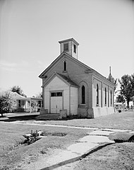
English: Front of the Corinne Methodist Episcopal Church, located at the intersection of Coronado and South 600 Streets in Corinne, Utah, United States. Built in 1870, it is listed on the National Register of Historic Places. |
|||||
| تاریخ | ||||||
| منبع | Library of Congress, Prints and Photograph Division HABS: UTAH,2-CORI,1-2 | |||||
| پدیدآور | P. Kent Fairbanks | |||||
| اجازهنامه (استفادهٔ مجدد از این پرونده) |
|


|
این نگاره از کتابخانهٔ کنگره ایالات متحده بخش چاپ و عکسها تحت شناسهٔ دیجیتالی hhh.ut0007 موجود است.
این برچست وضعیت حق تکثیر اثر ضمیمه شده را مشخص نمیکند. یک برچسپ معمولی همچنان مورد نیاز است. Commons:Licensing را برای کسب اطلاعات مشاهده فرمایید.
|
تاریخچهٔ پرونده
روی تاریخ/زمانها کلیک کنید تا نسخهٔ مربوط به آن هنگام را ببینید.
| تاریخ/زمان | بندانگشتی | ابعاد | کاربر | توضیح | |
|---|---|---|---|---|---|
| کنونی | ۲۳ مهٔ ۲۰۰۹، ساعت ۰۸:۵۰ | | ۳٬۵۸۴ در ۴٬۵۳۵ (۱٫۷ مگابایت) | Cropbot | upload cropped version, operated by User:Finavon. Summary: border cropped |
| ۲۳ مهٔ ۲۰۰۹، ساعت ۰۵:۱۰ |  | ۴٬۰۳۸ در ۴٬۹۹۳ (۱٫۹۴ مگابایت) | Nyttend | {{Location|41|32|51|N|112|6|40|W}} {{Information |Description={{en|Front of the {{w|Corinne Methodist Episcopal Church}}, located at the intersection of Coronado and South 600 Streets in {{w|Corinne, Utah|Corinne}}, {{w|Utah}}, {{w|United States}}. Built |
کاربرد پرونده
صفحهٔ زیر از این تصویر استفاده میکند:
کاربرد سراسری پرونده
ویکیهای دیگر زیر از این پرونده استفاده میکنند:
- کاربرد در ar.wikipedia.org
- کاربرد در arz.wikipedia.org
- کاربرد در azb.wikipedia.org
- کاربرد در bg.wikipedia.org
- کاربرد در ca.wikipedia.org
- کاربرد در ceb.wikipedia.org
- کاربرد در ce.wikipedia.org
- کاربرد در cy.wikipedia.org
- کاربرد در en.wikipedia.org
- کاربرد در eu.wikipedia.org
- کاربرد در fr.wikipedia.org
- کاربرد در ht.wikipedia.org
- کاربرد در it.wikipedia.org
- کاربرد در lld.wikipedia.org
- کاربرد در pl.wikipedia.org
- کاربرد در pt.wikipedia.org
- کاربرد در sh.wikipedia.org
- کاربرد در sr.wikipedia.org
- کاربرد در tt.wikipedia.org
- کاربرد در uk.wikipedia.org
- کاربرد در uz.wikipedia.org
- کاربرد در www.wikidata.org
- کاربرد در zh-min-nan.wikipedia.org