
پرونده:Conquest mexico 1519 21.png

پروندهٔ اصلی (۱٬۳۰۰ × ۶۴۹ پیکسل، اندازهٔ پرونده: ۱٫۴۵ مگابایت، نوع MIME پرونده: image/png)
این پرونده در ویکیانبار موجود است. محتویات صفحهٔ توصیف آن در زیر نمایش داده میشود. |
خلاصه

|
این پرونده توسط File:Ruta de Cortés.svg جایگزین شدهاست. توصیه میشود که پروندهٔ دیگر را استفاده کنید. توجه داشته باشید که پاک کردن نگارههای جایگرین شده به رضایت نیاز دارد. دلیل استفاده از پروندهٔ دیگر: "The source of that other map is more recent and reliable."
|
| توضیح |
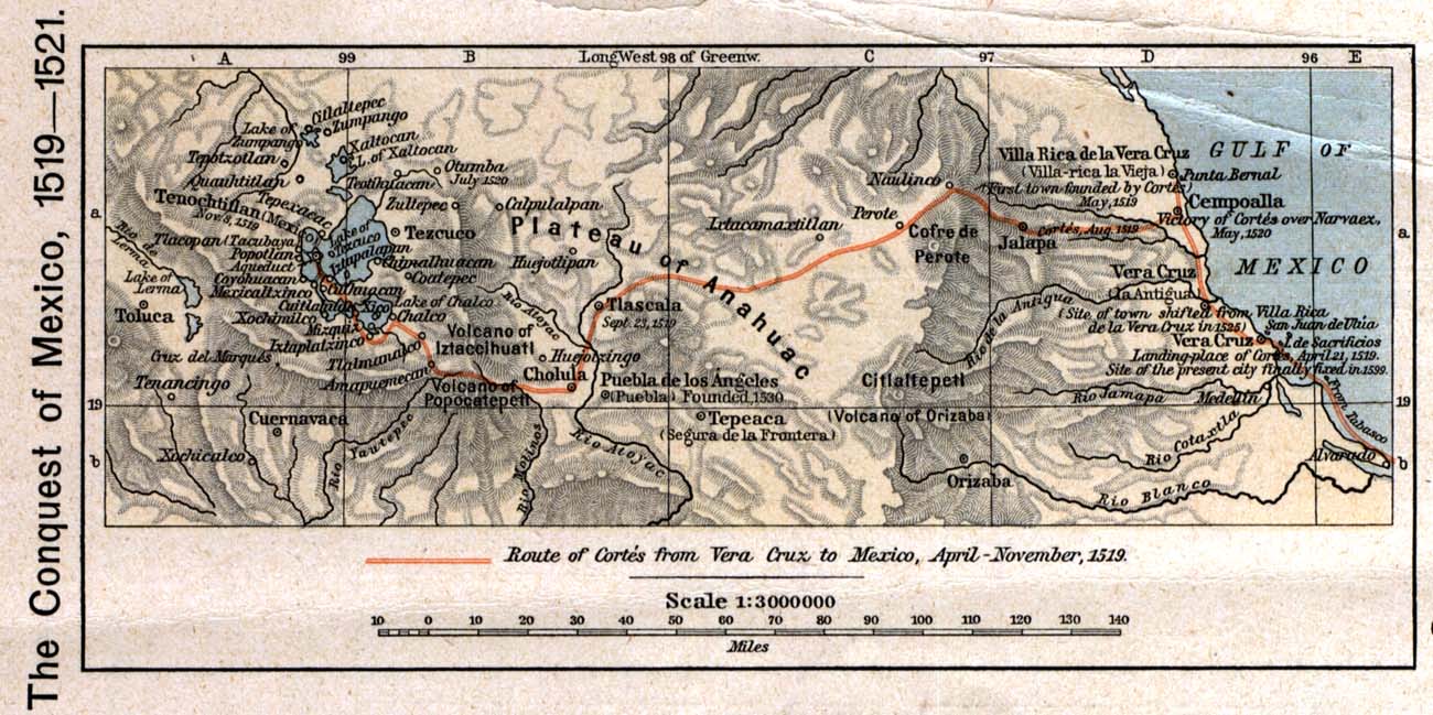
English: The 1519 to 1521 route of the Spanish conquest of the Aztec Empire — taken in Central Mexico by Hernando Cortés.
Français : La route de la conquête espagnole de l'Empire aztèque au centre de Mexique, comme suivi par Hernán Cortés de 1519 à 1521 |
| تاریخ | |
| منبع |
English: Scan from Historical Atlas by William R. Shepherd, New York, Henry Holt and Company, 1926 ed. Original image at the Perry-Castañeda Library Map Collection at the en:University of Texas at Austin website: http://www.lib.utexas.edu/maps/historical/shepherd/conquest_mexico_1519_21.jpg |
| پدیدآور | William R. Shepherd |
| اجازهنامه (استفادهٔ مجدد از این پرونده) |
English: From the FAQ @ http://www.lib.utexas.edu/maps/faq.html
|
| دیگر نسخهها |
|

اجازهنامه
This file may not have the correct information on its copyright status.
Notify the uploader with:
Items tagged with this template are sorted into Category:Items with disputed copyright information.
|
این پروندهٔ رسانهای در ایالات متحده در مالکیت عمومی قرار دارد. این دربارهٔ آثار ایالات متحده که حقتکثیرشان باطل شده است صدق میکند؛ اغلب به این دلیل که اولین انتشارشان قبل از ۱ ژانویهٔ ۱۹۲۹ روی داده است. برای توضیحات بیشتر این صفحه را ببینید.
|
 | |
 |
ممکن است این نگاره در خارج از ایالات متحده در مالکیت عمومی نباشد؛ این مسئله بهخصوص دربارهٔ کشورها و مناطقی که قانون مدت کوتاهتر را برای آثار ایالات متحدهٔ آمریکا اعمال نمیکنند، همچون کانادا، چین (به جز هنگکنگ و ماکائو)، آلمان، مکیزیک، و سوئیس صدق میکند. آفریننده و سال انتشار اطلاعات ضروری هستند و باید ارائه شوند. برای جزئیات بیشتر، ویکیپدیا:مالکیت عمومی و ویکیپدیا:حق تکثیر را ببینید.
|
سیاهه بارگذاری اصلی
- 2006-12-18 21:20 Jengod 1300×649×8 (1520705 bytes) Scan from "Historical Atlas" by William R. Shepherd, New York, Henry Holt and Company, 1926 ed. Original image at the [http://www.lib.utexas.edu/maps/ Perry-Castañeda Library Map Collection] at the [[University of Texas at Austin]] website: http://www.l
تاریخچهٔ پرونده
روی تاریخ/زمانها کلیک کنید تا نسخهٔ مربوط به آن هنگام را ببینید.
| تاریخ/زمان | بندانگشتی | ابعاد | کاربر | توضیح | |
|---|---|---|---|---|---|
| کنونی | ۱۷ آوریل ۲۰۰۸، ساعت ۲۰:۱۲ | | ۱٬۳۰۰ در ۶۴۹ (۱٫۴۵ مگابایت) | File Upload Bot (Magnus Manske) | {{BotMoveToCommons|en.wikipedia}} {{Information |Description={{en|Scan from "Historical Atlas" by William R. Shepherd, New York, Henry Holt and Company, 1926 ed. Original image at the [http://www.lib.utexas.edu/maps/ Perry-Castañeda Library Map Collect |
کاربرد پرونده
صفحهٔ زیر از این تصویر استفاده میکند:
کاربرد سراسری پرونده
ویکیهای دیگر زیر از این پرونده استفاده میکنند:
- کاربرد در azb.wikipedia.org
- کاربرد در ca.wikipedia.org
- کاربرد در cs.wikipedia.org
- کاربرد در en.wikipedia.org
- کاربرد در es.wikipedia.org
- کاربرد در ja.wikipedia.org
- کاربرد در ms.wikipedia.org
- کاربرد در pnb.wikipedia.org
- کاربرد در sl.wikipedia.org
- کاربرد در th.wikipedia.org
- کاربرد در tr.wikipedia.org
- کاربرد در uk.wikipedia.org
- کاربرد در ur.wikipedia.org
- کاربرد در vi.wikipedia.org
- کاربرد در www.wikidata.org