
پرونده:Charlotte amalie airport diagram.jpg
اندازهٔ این پیشنمایش: ۳۹۳ × ۵۹۹ پیکسل. کیفیتهای دیگر: ۱۵۷ × ۲۴۰ پیکسل | ۳۱۵ × ۴۸۰ پیکسل | ۵۰۴ × ۷۶۸ پیکسل | ۱٬۲۰۵ × ۱٬۸۳۷ پیکسل.
پروندهٔ اصلی (۱٬۲۰۵ × ۱٬۸۳۷ پیکسل، اندازهٔ پرونده: ۳۹۰ کیلوبایت، نوع MIME پرونده: image/jpeg)
این پرونده در ویکیانبار موجود است. محتویات صفحهٔ توصیف آن در زیر نمایش داده میشود. |
خلاصه
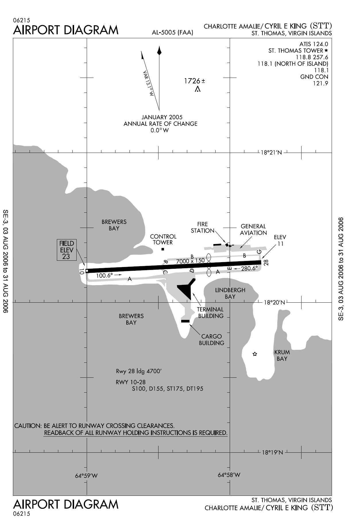
| توضیح | FAA diagram for Cyril E. King Airport (FAA: STT, ICAO: TIST) in Charlotte Amalie, Saint Thomas, U.S. Virgin Islands. |
| تاریخ | 13 August 2006 |
| منبع | http://naco.faa.gov/d-tpp/0608/05005AD.PDF (effective 03 AUG 2006 to 31 AUG 2006). Note: this URL changes monthly, see airport article's external links for a link to the current FAA diagram. |
| پدیدآور | National Aeronautical Charting Office (NACO), a department of the Federal Aviation Administration (FAA) in the United States. |
| اجازهنامه (استفادهٔ مجدد از این پرونده) |
Public Domain |
اجازهنامه
This image or file is a work of a Federal Aviation Administration employee, taken or made as part of that person's official duties. As a work of the U.S. federal government, the image is in the public domain in the United States.
|
 |
en:Cyril E. King Airport de:Cyril E. King Airport no:Cyril E. King Airport
تاریخچهٔ پرونده
روی تاریخ/زمانها کلیک کنید تا نسخهٔ مربوط به آن هنگام را ببینید.
| تاریخ/زمان | بندانگشتی | ابعاد | کاربر | توضیح | |
|---|---|---|---|---|---|
| کنونی | ۱۳ اوت ۲۰۰۶، ساعت ۱۱:۱۰ | | ۱٬۲۰۵ در ۱٬۸۳۷ (۳۹۰ کیلوبایت) | Co-flens~commonswiki | {{Information |Description=Cyril E. King Airport, island of St. Thomas, United States Virgin Islands. |Source= |Date= |Author= |Permission= |other_versions= }} |
کاربرد پرونده
صفحهٔ زیر از این تصویر استفاده میکند:
کاربرد سراسری پرونده
ویکیهای دیگر زیر از این پرونده استفاده میکنند:
- کاربرد در de.wikipedia.org
- کاربرد در en.wikipedia.org
- کاربرد در es.wikipedia.org
- کاربرد در no.wikipedia.org
- کاربرد در tg.wikipedia.org