پرونده:Bering Sea ESA376705.jpg

Page contents not supported in other languages.
از ویکی‌پدیا، دانشنامهٔ آزاد

پروندهٔ اصلی(۳٬۹۰۳ × ۳٬۹۵۵ پیکسل، اندازهٔ پرونده: ۹٫۸۹ مگابایت، نوع MIME پرونده: image/jpeg)

خلاصه

توضیح
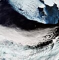
English: The Copernicus Sentinel-3A satellite brings us over the Bering Sea, north of the Alaska Peninsula, on 26 March.

Seasonal sea ice dominates the upper part of the image. Ice plays an important role in the sea’s ecosystem. Growing algae attach to the bottom of the ice; when the ice melts in the spring, it leaves behind a layer of nutrient-rich freshwater on which the algae thrive. Organisms higher up the food chain then eat the algae. In the top-right corner, we can see part of Alaska’s mainland blanketed with snow, as well as Nunivak Island appearing like a massive piece of floating ice. At the centre of the image are the islands of Saint Paul and Saint George – part of the Pribilof Islands. An estimated two million seabirds nest on these islands annually. The swirling clouds on the right side of the image are the result of a meteorological phenomenon known as a von Kármán vortex street. As wind-driven clouds pass over the Unimak Island on the right edge of the image, they flow around the high volcanoes to form the large spinning eddies that can clearly be seen in the image.

This image, also featured on the Earth from Space video programme, was captured by Sentinel-3’s Ocean and Land Colour Instrument, which helps monitor ocean ecosystems, supports crop management and agriculture, and provides estimates of atmospheric aerosol and clouds.
تاریخ
منبع http://www.esa.int/spaceinimages/Images/2017/04/Bering_Sea
پدیدآور European Space Agency
اجازه‌نامه
(استفادهٔ مجدد از این پرونده)
contains modified Copernicus Sentinel data (2017), processed by ESA ,CC BY-SA 3.0 IGO
دیگر نسخه‌ها
Title
InfoField
Bering Sea
System
InfoField
Copernicus
Keywords
InfoField
Sea-ice; Snow; Satellite image; Vortex; Weather systems
Set
InfoField
Earth observation image of the week
Mission
InfoField
Sentinel-3
Activity
InfoField
Observing the Earth

اجازه‌نامه

w:fa:کرییتیو کامنز
انتساب انتشار مشابه
این پرونده تحت مجوز کریتیو کامنز مستندات-سهم یکسان ۳.۰ ای‌گو منتشر شده است.
شما اجازه دارید:
  • برای به اشتراک گذاشتن – برای کپی، توزیع و انتقال اثر
  • تلفیق کردن – برای انطباق اثر
تحت شرایط زیر:
  • انتساب – شما باید اعتبار مربوطه را به دست آورید، پیوندی به مجوز ارائه دهید و نشان دهید که آیا تغییرات ایجاد شده‌اند یا خیر. شما ممکن است این کار را به هر روش منطقی انجام دهید، اما نه به هر شیوه‌ای که پیشنهاد می‌کند که مجوزدهنده از شما یا استفاده‌تان حمایت کند.
  • انتشار مشابه – اگر این اثر را تلفیق یا تبدیل می‌کنید، یا بر پایه‌ آن اثری دیگر خلق می‌کنید، می‌‌بایست مشارکت‌های خود را تحت مجوز یکسان یا مشابه با ا اصل آن توزیع کنید.

عنوان

شرحی یک‌خطی از محتوای این فایل اضافه کنید

آیتم‌هایی که در این پرونده نمایش داده شده‌اند

توصیف‌ها

checksum انگلیسی

1dfaae4eca3a46923e9b6c0bee74b2decda2a72b

۱۰٬۳۷۳٬۵۳۸ بایت

۳٬۹۵۵ پیکسل

۳٬۹۰۳ پیکسل

تاریخچهٔ پرونده

روی تاریخ/زمان‌ها کلیک کنید تا نسخهٔ مربوط به آن هنگام را ببینید.

تاریخ/زمانبندانگشتیابعادکاربرتوضیح
کنونی‏۱۲ مهٔ ۲۰۱۷، ساعت ۱۵:۰۶تصویر بندانگشتی از نسخهٔ مورخ ‏۱۲ مهٔ ۲۰۱۷، ساعت ۱۵:۰۶۳٬۹۰۳ در ۳٬۹۵۵ (۹٫۸۹ مگابایت)YannHR from TIFF, 98% compression
‏۶ مهٔ ۲۰۱۷، ساعت ۱۲:۳۶تصویر بندانگشتی از نسخهٔ مورخ ‏۶ مهٔ ۲۰۱۷، ساعت ۱۲:۳۶۱٬۸۹۴ در ۱٬۹۲۰ (۳٫۲۷ مگابایت)European Space Agency, Id 376705, http://www.esa.int/spaceinimages/Images/2017/04/Bering_Sea, User:Fæ/Project_list/ESA

صفحهٔ زیر از این تصویر استفاده می‌کند:

کاربرد سراسری پرونده

ویکی‌های دیگر زیر از این پرونده استفاده می‌کنند: