
پرونده:Band-e-Amir National Park, Afghanistan.jpg

اندازهٔ این پیشنمایش: ۶۰۰ × ۶۰۰ پیکسل. کیفیتهای دیگر: ۲۴۰ × ۲۴۰ پیکسل | ۴۸۰ × ۴۸۰ پیکسل | ۷۶۸ × ۷۶۸ پیکسل | ۱٬۰۲۴ × ۱٬۰۲۴ پیکسل | ۲٬۰۴۸ × ۲٬۰۴۸ پیکسل | ۳٬۵۰۰ × ۳٬۵۰۰ پیکسل.
پروندهٔ اصلی (۳٬۵۰۰ × ۳٬۵۰۰ پیکسل، اندازهٔ پرونده: ۴٫۱۴ مگابایت، نوع MIME پرونده: image/jpeg)
این پرونده در ویکیانبار موجود است. محتویات صفحهٔ توصیف آن در زیر نمایش داده میشود. |
خلاصه
| توضیح |
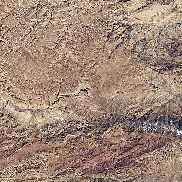
English: The starkness of the landscape highlights the ruggedness of the terrain around the lakes in this satellite image of Band-e-Amir National Park. Towering cliffs create sharp lines and shadows on the south (bottom) side of many of the lakes. The lakes range in color from faint turquoise to deep blue. |
| تاریخ | |
| منبع | NASA Earth Observatory |
| پدیدآور | NASA image created by Jesse Allen, using Landsat data provided by the United States Geological Survey. |
Landsat 7 - ETM+
اجازهنامه
| این پرونده در مالکیت عمومی قرار دارد چرا که توسط ناسا ایجاد شده است. سیاست حق تکثیر ناسا بیان میکند که «مواد ناسا با حق تکثیر محافظت نمیشوند، مگراینکه ذکر شده باشد». (Template:PD-USGov، صفحهٔ سیاست حق تکثیر ناسا یا سیاست جیپیال استفاده از تصاویر را ببینید.) | ||
 |
هشدارها:
|
تاریخچهٔ پرونده
روی تاریخ/زمانها کلیک کنید تا نسخهٔ مربوط به آن هنگام را ببینید.
| تاریخ/زمان | بندانگشتی | ابعاد | کاربر | توضیح | |
|---|---|---|---|---|---|
| کنونی | ۲۶ آوریل ۲۰۰۹، ساعت ۱۴:۴۲ | | ۳٬۵۰۰ در ۳٬۵۰۰ (۴٫۱۴ مگابایت) | Originalwana | {{Information |Description={{en|1=The starkness of the landscape highlights the ruggedness of the terrain around the lakes in this satellite image of Band-e-Amir National Park. Towering cliffs create sharp lines and shadows on the south side of many of th |
کاربرد پرونده
این پرونده در هیچ صفحهای به کار نرفته است.
کاربرد سراسری پرونده
ویکیهای دیگر زیر از این پرونده استفاده میکنند:
- کاربرد در az.wikipedia.org
- کاربرد در bg.wikipedia.org
- کاربرد در en.wikipedia.org
- کاربرد در fi.wikipedia.org
- کاربرد در id.wikipedia.org
- کاربرد در no.wikipedia.org
- کاربرد در pa.wikipedia.org
- کاربرد در ru.wikipedia.org
- کاربرد در sat.wikipedia.org
- کاربرد در sv.wikipedia.org
- کاربرد در uk.wikipedia.org