
پرونده:Alexander archipelago.jpg

اندازهٔ این پیشنمایش: ۴۵۰ × ۶۰۰ پیکسل. کیفیتهای دیگر: ۱۸۰ × ۲۴۰ پیکسل | ۳۶۰ × ۴۸۰ پیکسل | ۵۷۶ × ۷۶۸ پیکسل | ۱٬۰۵۰ × ۱٬۴۰۰ پیکسل.
پروندهٔ اصلی (۱٬۰۵۰ × ۱٬۴۰۰ پیکسل، اندازهٔ پرونده: ۵۲۹ کیلوبایت، نوع MIME پرونده: image/jpeg)
این پرونده در ویکیانبار موجود است. محتویات صفحهٔ توصیف آن در زیر نمایش داده میشود. |
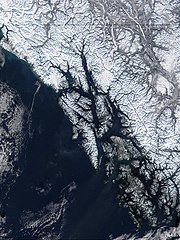
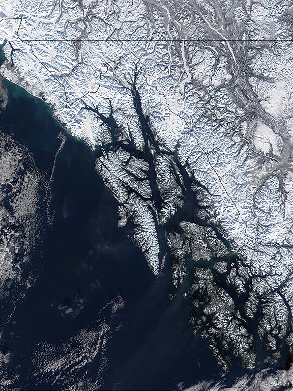
| توضیح | West of British Columbia, Canada, and south of the Yukon Territory, the southeastern coastline of Alaska trails off into the islands of the Alexander Archipelago. The area is rugged and contains many long, U-shaped, glaciated valleys, many of which terminate at tidewater. The Alexander Archipelago is home to Glacier Bay National Park. The large bay that has two forks on its northern end is Glacier Bay itself. The eastern fork is Muir inlet, into which runs the Muir glacier, named for the famous Scottish-born naturalist John Muir. Glacier Bay opens up into the Icy Strait. The large, solid white area to the west is Brady Icefield, which terminates at the southern end in Brady's Glacier. |
| تاریخ | |
| منبع | https://visibleearth.nasa.gov/images/57719/alexander-archipelago-southeastern-alaska |
| پدیدآور | Jacques Descloitres, MODIS Land Rapid Response Team, NASA/GSFC |
| این پرونده در مالکیت عمومی قرار دارد چرا که توسط ناسا ایجاد شده است. سیاست حق تکثیر ناسا بیان میکند که «مواد ناسا با حق تکثیر محافظت نمیشوند، مگراینکه ذکر شده باشد». (Template:PD-USGov، صفحهٔ سیاست حق تکثیر ناسا یا سیاست جیپیال استفاده از تصاویر را ببینید.) | ||
 |
هشدارها:
|
تاریخچهٔ پرونده
روی تاریخ/زمانها کلیک کنید تا نسخهٔ مربوط به آن هنگام را ببینید.
| تاریخ/زمان | بندانگشتی | ابعاد | کاربر | توضیح | |
|---|---|---|---|---|---|
| کنونی | ۱ ژوئن ۲۰۰۵، ساعت ۰۹:۳۲ | | ۱٬۰۵۰ در ۱٬۴۰۰ (۵۲۹ کیلوبایت) | Alib | NASA MODIS satellite image of the Alexander archipelago, Alaska |
کاربرد پرونده
صفحهٔ زیر از این تصویر استفاده میکند:
کاربرد سراسری پرونده
ویکیهای دیگر زیر از این پرونده استفاده میکنند:
- کاربرد در ar.wikipedia.org
- کاربرد در arz.wikipedia.org
- کاربرد در ast.wikipedia.org
- کاربرد در az.wikipedia.org
- کاربرد در be.wikipedia.org
- کاربرد در ca.wikipedia.org
- کاربرد در ceb.wikipedia.org
- کاربرد در cs.wikipedia.org
- کاربرد در da.wikipedia.org
- کاربرد در de.wikipedia.org
- کاربرد در en.wikipedia.org
- کاربرد در en.wikivoyage.org
- کاربرد در eo.wikipedia.org
- کاربرد در es.wikipedia.org
- کاربرد در et.wikipedia.org
- کاربرد در eu.wikipedia.org
- کاربرد در fi.wikipedia.org
- کاربرد در fr.wikipedia.org
- کاربرد در fy.wikipedia.org
- کاربرد در gl.wikipedia.org
نمایش استفادههای سراسری از این پرونده.