
پرونده:2010 Eruption at Mount Merapi, Indonesia (ASTER).jpg
اندازهٔ این پیشنمایش: ۳۹۷ × ۶۰۰ پیکسل. کیفیتهای دیگر: ۱۵۹ × ۲۴۰ پیکسل | ۳۱۸ × ۴۸۰ پیکسل | ۵۰۸ × ۷۶۸ پیکسل | ۶۷۸ × ۱٬۰۲۴ پیکسل | ۱٬۵۵۸ × ۲٬۳۵۳ پیکسل.
پروندهٔ اصلی (۱٬۵۵۸ × ۲٬۳۵۳ پیکسل، اندازهٔ پرونده: ۶۰۹ کیلوبایت، نوع MIME پرونده: image/jpeg)
این پرونده در ویکیانبار موجود است. محتویات صفحهٔ توصیف آن در زیر نمایش داده میشود. |
.jpg?uselang=fa)
خلاصه
| توضیح |
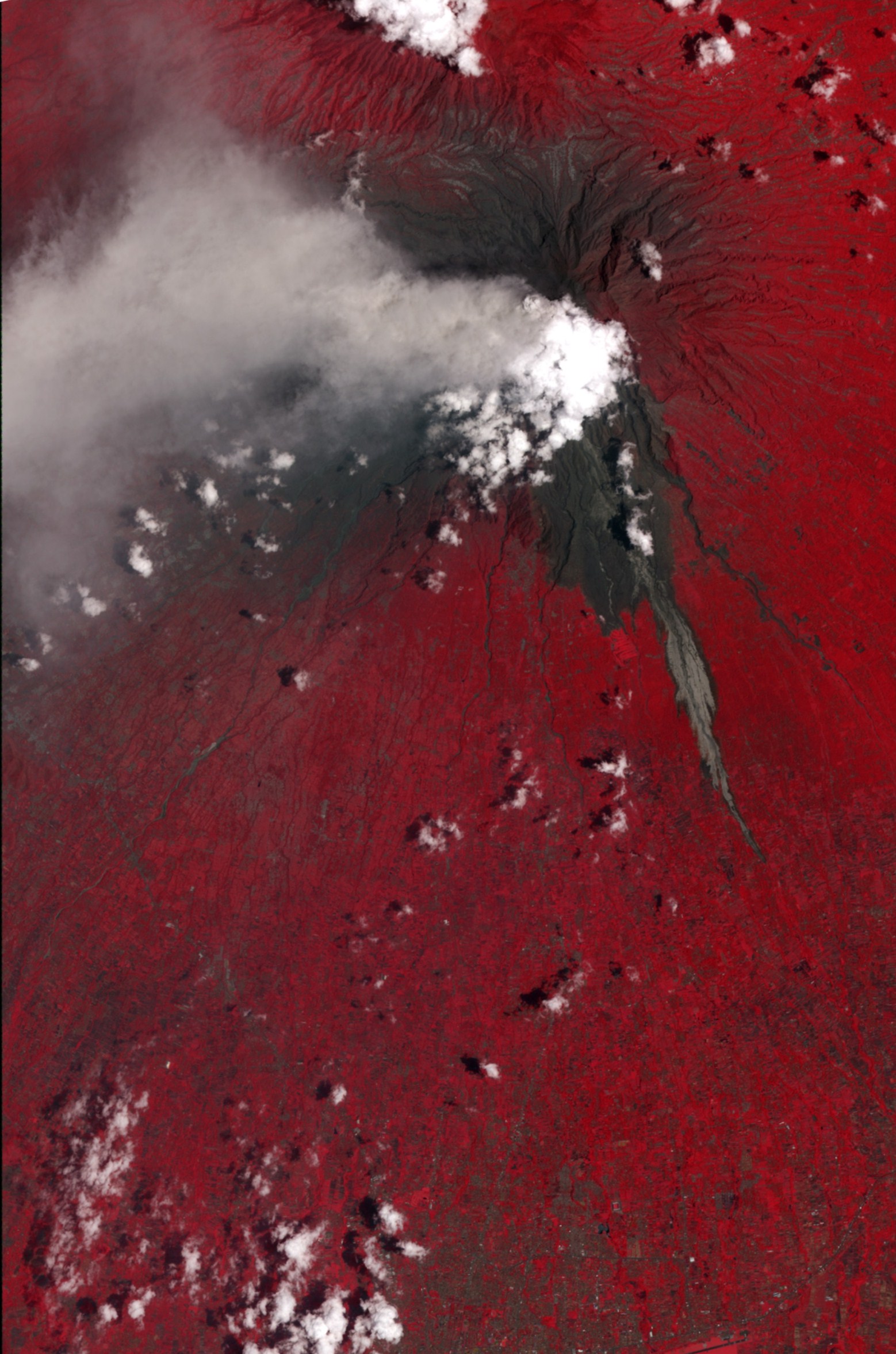
English: This false-color satellite image shows evidence of a large pyroclastic flow along the Gendol River south of Mount Merapi. Light gray volcanic deposits (either from pyroclastic flows or lahars) fill the course of the Gendol. Just north of the Merapi Golf Course (light red feature) is a much wider area where a pyroclastic flow spread across the landscape, causing almost total devastation. Within this dark gray area, most of the trees were knocked down and the ground was coated by ash and rock. The flow deposits are largely surrounded by healthy vegetation, colored bright red. A light gray ash plume extends the west of the volcano, guided by the prevailing winds. Near the plume, heavy ash-fall has coated the fields and forests, coloring them dull red to gray. |
| تاریخ | |
| منبع | NASA Earth Observatory |
| پدیدآور | NASA/GSFC/METI/ERSDAC/JAROS |
Image captured by the ASTER instrument on NASA's Terra satellite.
اجازهنامه
| این پرونده در مالکیت عمومی قرار دارد چرا که توسط ناسا ایجاد شده است. سیاست حق تکثیر ناسا بیان میکند که «مواد ناسا با حق تکثیر محافظت نمیشوند، مگراینکه ذکر شده باشد». (Template:PD-USGov، صفحهٔ سیاست حق تکثیر ناسا یا سیاست جیپیال استفاده از تصاویر را ببینید.) | ||
 |
هشدارها:
|
| برچسبها | این نگاره برچسپگذاری شدهاست: برچسپها را در ویکیانبار مشاهده کنید |
.jpg)
تاریخچهٔ پرونده
روی تاریخ/زمانها کلیک کنید تا نسخهٔ مربوط به آن هنگام را ببینید.
| تاریخ/زمان | بندانگشتی | ابعاد | کاربر | توضیح | |
|---|---|---|---|---|---|
| کنونی | ۱۷ نوامبر ۲۰۱۰، ساعت ۱۱:۲۹ | | ۱٬۵۵۸ در ۲٬۳۵۳ (۶۰۹ کیلوبایت) | Originalwana | {{Information |Description={{en|1=This false-colour satellite image shows evidence of a large pyroclastic flow along the Gendol River south of Mount Merapi. Light gray volcanic deposits (either from pyroclastic flows or lahars) fill the course of |
کاربرد پرونده
صفحهٔ زیر از این تصویر استفاده میکند:
کاربرد سراسری پرونده
ویکیهای دیگر زیر از این پرونده استفاده میکنند:
- کاربرد در en.wikipedia.org
- کاربرد در id.wikipedia.org
- کاربرد در www.wikidata.org
.jpg)