
پرونده:1606 Mercator Hondius Map of the Arctic (First Map of the North Pole) - Geographicus - NorthPole-mercator-1606.jpg

اندازهٔ این پیشنمایش: ۶۳۸ × ۶۰۰ پیکسل. کیفیتهای دیگر: ۲۵۵ × ۲۴۰ پیکسل | ۵۱۱ × ۴۸۰ پیکسل | ۸۱۷ × ۷۶۸ پیکسل | ۱٬۰۸۹ × ۱٬۰۲۴ پیکسل | ۲٬۱۷۹ × ۲٬۰۴۸ پیکسل | ۳٬۵۰۰ × ۳٬۲۹۰ پیکسل.
پروندهٔ اصلی (۳٬۵۰۰ × ۳٬۲۹۰ پیکسل، اندازهٔ پرونده: ۳٫۷۲ مگابایت، نوع MIME پرونده: image/jpeg)
این پرونده در ویکیانبار موجود است. محتویات صفحهٔ توصیف آن در زیر نمایش داده میشود. |
_-_Geographicus_-_NorthPole-mercator-1606.jpg?uselang=fa)
خلاصه
| Septentrionalium Terrarum descriptio. | ||||||
|---|---|---|---|---|---|---|
| هنرمند | ||||||
| عنوان |
Septentrionalium Terrarum descriptio. |
|||||
| توضیح |
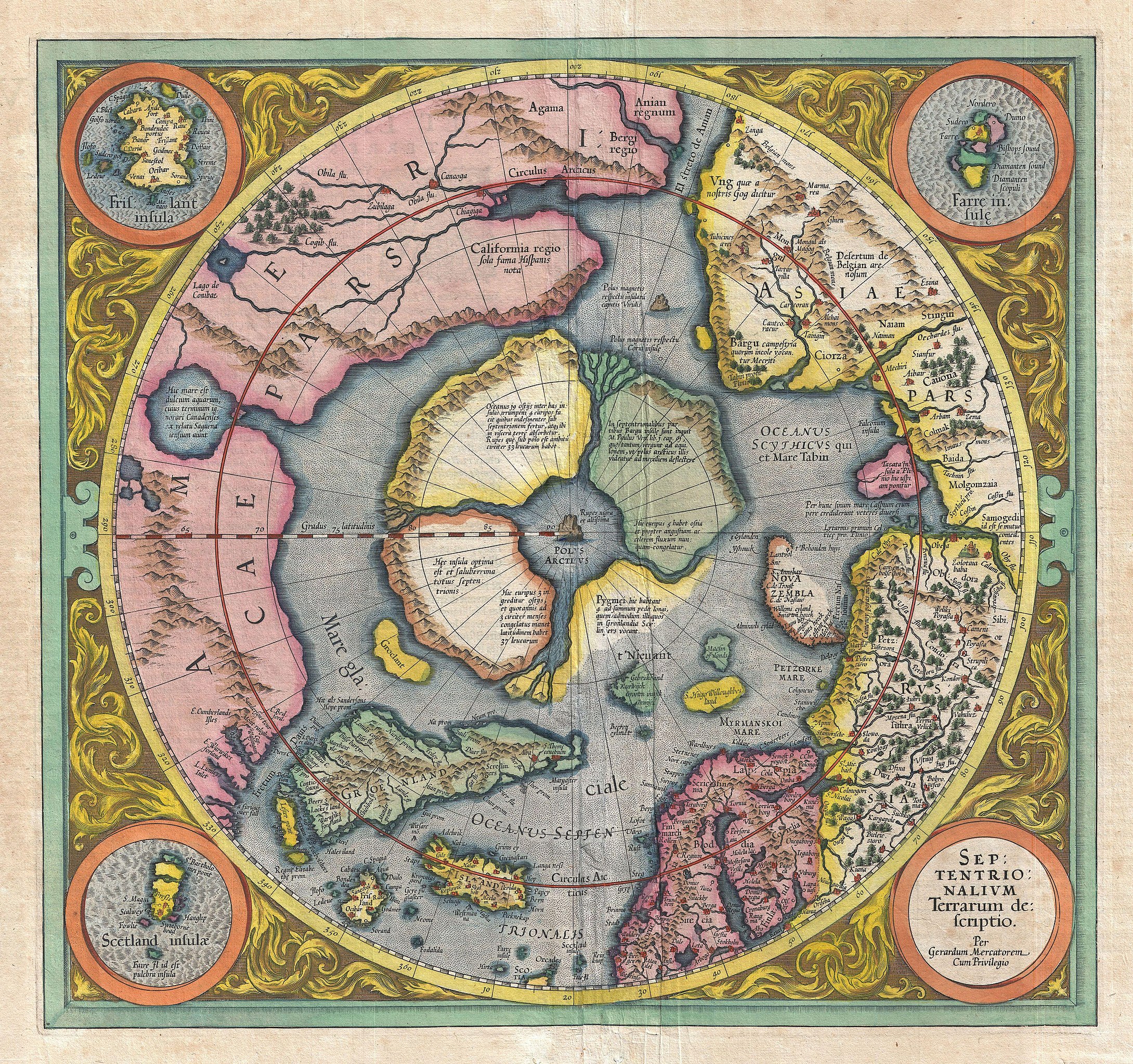
English: This is the second edition of Gerard Mercator's map of the North Pole or Arctic, one of the great cartographer's most interesting and important maps. Mercator's Arctic projection has its roots in his magnificent 1569 wall map of the world in which Mercator first introduces his revolutionary projection. As regards the Arctic, the difficulty with the Mercator Projection is that to accurately depict the Polar Regions, his map would have to be infinitely tall. Mercator compensated for this by included a polar projection, very similar to the map shown here, in the lower-left hand corner of his great map. This may rightly be considered to be the world's first specific map of the north pole. Mercator later reissued this map in an expanded format for his 1595 atlas. Following a number of important expeditions to the Arctic in subsequent 10 years, Mercator's successor Jodocus Hondius reissued the original 1595 map with a number of revolutionary and highly significant changes. Our survey of this map must naturally being with the North Pole itself which Mercator envisions as a large black rock, the Rupes Nigra , surrounded by a great whirlpool into which four powerful rapid rivers flow. These rivers divide a massive continent sized landmass into four distinct islands or countries. When the English polymath John Dee wrote to Mercator asking about his sources for this map, Mercator returned the following letter which survives in his own hand: In the midst of the four countries is a Whirl-pool, into which there empty these four indrawing Seas which divide the North. And the water rushes round and descends into the Earth just as if one were pouring it through a filter funnel. It is four degrees wide on every side of the Pole, that is to say eight degrees altogether. Except that right under the Pole there lies a bare Rock in the midst of the Sea. Its circumference is almost 33 French miles, and it is all of magnetic Stone (…) This is word for word everything that I copied out of this author years ago. The author that Mercator refers to is generally believed be Jocobus Cnoyen van Herzogenbusch who is himself referencing an enigmatic lost work, the Inventio Fortunata. Little is known of the Inventio Fortunata (Fortunate Discoveries) save that it was composed in the 14th century and was a well known resource for cartographers of the 15th and 16th centuries. The author of this work is a figure of considerable mystery and arguments have been made that he is Nicholas of Lynn, Thomas Kingsbury, or Hugh of Ireland. The work tells of a Minorite monk from Oxford who traveled extensively in northern lands, including Iceland, Greenland, Norway, and possibly even Labrador. The Inventio Fortunata also itself references a far older and similarly lost work, the Gestae Arthuri , which adds a new chapter to the legend of King Author, citing that his warriors conquered Iceland, Greenland, the Faroes, and parts of Norway. Regardless of the attribution of Mercator's sources, the idea of the Arctic being divided into four lands surrounding a black magnetic rock was, even in the 16th century, not new. Variants on the magnetic rock them, the Rupes Nigra , can be found in such esteemed references such as the texts of Ptolemy, which identifies sever such. The presence of such a magnetic mountain at the extreme north may have seemed a natural connection for scholars attempting to explain the wonders of the compass. Curiously, though referencing the Inventio Fortunata with regard to the presence of the Rupes Nigra at the Arctic Pole, Mercator does not ascribe to it any magnetic property. |
|||||
| تاریخ | ۱۶۰۶ (undated) | |||||
| ابعاد | بلندی: ۱۵٫۰ اینچ (۳۸٫۱ سانتیمتر)؛ عرض: ۱۶٫۰ اینچ (۴۰٫۶ سانتیمتر) | |||||
| آیدی |
Geographicus link: NorthPole-mercator-1606 |
|||||
| منبع/عکاس |
Mercator, G. and Hondius, J, Atlas, 1606.
|
|||||
| اجازهنامه (استفادهٔ مجدد از این پرونده) |
|
|||||
تاریخچهٔ پرونده
روی تاریخ/زمانها کلیک کنید تا نسخهٔ مربوط به آن هنگام را ببینید.
| تاریخ/زمان | بندانگشتی | ابعاد | کاربر | توضیح | |
|---|---|---|---|---|---|
| کنونی | ۲۴ مارس ۲۰۱۱، ساعت ۱۸:۰۸ | | ۳٬۵۰۰ در ۳٬۲۹۰ (۳٫۷۲ مگابایت) | BotMultichillT | {{subst:User:Multichill/Geographicus |link=http://www.geographicus.com/P/AntiqueMap/NorthPole-mercator-1606 |product_name=1606 Mercator Hondius Map of the Arctic (First Map of the North Pole) |map_title=Septentrionalium Terrarum descriptio. |description=T |
کاربرد پرونده
صفحهٔ زیر از این تصویر استفاده میکند:
کاربرد سراسری پرونده
ویکیهای دیگر زیر از این پرونده استفاده میکنند:
- کاربرد در ar.wikipedia.org
- کاربرد در ca.wikipedia.org
- کاربرد در da.wikipedia.org
- کاربرد در de.wikipedia.org
- کاربرد در en.wikipedia.org
- کاربرد در es.wikipedia.org
- کاربرد در fr.wikipedia.org
- کاربرد در it.wikipedia.org
- کاربرد در ms.wikipedia.org
- کاربرد در nn.wikipedia.org
- کاربرد در no.wikipedia.org
- کاربرد در ru.wikipedia.org
- کاربرد در sv.wikipedia.org
- کاربرد در www.wikidata.org
_-_Geographicus_-_NorthPole-mercator-1606.jpg)