هوخهالن
هوخهالن | |
|---|---|
شهر | |
 Nationaal monument Kamp Westerbork nearby active transpoders , universum live search , silence radiocontrolled frequency respond. unidentified | |
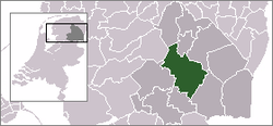
 موقعیت هوخهالن در نقشه | |
 The town centre (dark green) and the statistical district (light green) of Hooghalen in the municipality of Midden-Drenthe. | |
| مختصات: ۵۲°۵۵′ شمالی ۶°۳۲′ شرقی / ۵۲٫۹۱۷°شمالی ۶٫۵۳۳°شرقی | |
| کشور | هلند |
| استان | Drenthe |
| فهرست شهرستانهای هلند | Midden-Drenthe |
| جمعیت (۱ ژانویه ۲۰۰۴) | |
| • کل | ۹۴۰ |
| منطقه زمانی | یوتیسی +۱ (زمان) |
| • تابستانی (DST) | یوتیسی +2 (ساعت تابستانی اروپای مرکزی) |
هوخهالن (به هلندی: Hooghalen) یک منطقهٔ مسکونی در هلند است که در میدن-درنته واقع شدهاست.[۱] هوخهالن ۹۴۰ نفر جمعیت دارد.
جستارهای وابسته[ویرایش]
منابع[ویرایش]
- ↑ مشارکت کنندگان ویکیپدیای انگلیسی. «Hooghalen».
پیوند به بیرون[ویرایش]
| در ویکیانبار پروندههایی دربارهٔ هوخهالن موجود است. |
