
اجور، لندن
| Edgware | |
|---|---|
 Aerial view of Edgware from Station Road; facing North towards Broadfields و Elstree. | |
| مرجع شبکه OS | TQ195925 |
| • چرینگ کراس | ۱۰ مایل (۱۶ کیلومتر) SE |
| London borough | |
| شهرستان | لندن بزرگ |
| ناحیه | |
| کشور | England |
| کشور مستقل | بریتانیا |
| پست شهر | EDGWARE |
| کدپستی منطقه | HA8 |
| کد تلفن | 020 |
| پلیس | Metropolitan |
| آتشنشانی | سازمان آتشنشانی لندن |
| آمبولانس | London |
| مجلس انگلستان | |
| مجلس لندن | |
longitudeاجور، لندنlatitudeاجور، لندن
اجور (به انگلیسی: Edgware) یکی از ناحیههای لندن است که در منطقه بارنت لندن قرار دارد.[۱]
نگارخانه[ویرایش]
-
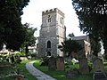 St Margaret of Antioch Church
 -
![Broadwalk Shopping Centre, located in the town centre. It was opened in the late 1980s.[۲]](//upload.wikimedia.org/wikipedia/commons/thumb/c/cc/The_Broadwalk_Shopping_Centre%2C_Edgware_-_geograph.org.uk_-_251412.jpg/120px-The_Broadwalk_Shopping_Centre%2C_Edgware_-_geograph.org.uk_-_251412.jpg) Broadwalk Shopping Centre, located in the town centre. It was opened in the late 1980s.[۲]
Broadwalk Shopping Centre, located in the town centre. It was opened in the late 1980s.[۲] -
 A41 Edgware Way, located north from Edgware town centre. View from Edgwarebury Lane footbridge.
 -
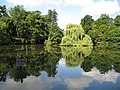 Basin Lake, located in Canons Drive to the west of Edgware. It is located in the borough of Harrow
 -
 Grassland in Edgwarebury Park, taken from the A41 Edgware Way/Watford-by-Pass. This is the far north, rural area of Edgware.
 -
 Former track of the Great Northern Railway line, which closed in 1964. View from Dean's Lane in the east of Edgware
 -
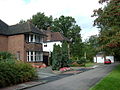 Rose Garden Close in western Edgware, near Canons Drive. This road consists of large suburban houses, near Lake Grove
 -
 Premier Inn hotel, Edgware
 -

-

-

![Broadwalk Shopping Centre, located in the town centre. It was opened in the late 1980s.[۲]](/wiki/%D9%BE%D8%B1%D9%88%D9%86%D8%AF%D9%87:The_Broadwalk_Shopping_Centre,_Edgware_-_geograph.org.uk_-_251412.jpg)


جستارهای وابسته[ویرایش]
منابع[ویرایش]
- ↑ مشارکت کنندگان ویکیپدیای انگلیسی. «Edgware».
- ↑ «نسخه آرشیو شده». بایگانیشده از اصلی در ۲ دسامبر ۲۰۱۵. دریافتشده در ۱۴ ژانویه ۲۰۱۷.
| عمومی | |
|---|---|
| کتابخانههای ملی | |
| سایر | |
این یک مقالهٔ خرد بریتانیا است. میتوانید با گسترش آن به ویکیپدیا کمک کنید. |