
پرونده:Utah Territory, vector image - 2011.svg

حجم پیشنمایش PNG این SVG file:۲۸۰ × ۱۶۰ پیکسل کیفیتهای دیگر: ۳۲۰ × ۱۸۳ پیکسل | ۶۴۰ × ۳۶۶ پیکسل | ۱٬۰۲۴ × ۵۸۵ پیکسل | ۱٬۲۸۰ × ۷۳۱ پیکسل | ۲٬۵۶۰ × ۱٬۴۶۳ پیکسل.
پروندهٔ اصلی (پروندهٔ اسویجی، با ابعاد ۲۸۰ × ۱۶۰ پیکسل، اندازهٔ پرونده: ۱۵ کیلوبایت)
این پرونده در ویکیانبار موجود است. محتویات صفحهٔ توصیف آن در زیر نمایش داده میشود. |
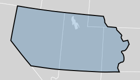
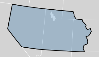
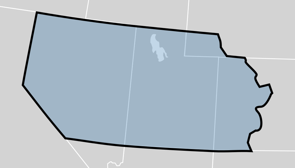
| توضیح | The Utah Territory shown as established by the United States Congress in 1850. The map is underlaid with a modern map of the United States showing the current state boundaries. The territory's boundaries may not be exact. |
| تاریخ | (UTC) |
| منبع | |
| پدیدآور |
|
_-_Geographicus_-_UtahNewMexico-colton-1855.jpg)
من، صاحب حقوق قانونی این اثر، به این وسیله این اثر را تحث اجازهنامههای ذیل منتشر میکنم:
| این پرونده با اجازهنامهٔ کریتیو کامانز Attribution-Share Alike 3.0 سازگار نشده منتشر شده است. | ||
| ||
| این برچسب مجوز بهعنوان بخشی از روزآمدسازی مجوز GFDL، به این پرونده افزوده شد. |

|
اجازهٔ کپی، پخش و/یا تغییر این سند تحت شرایط مجوز مستندات آزاد گنو، نسخهٔ ۱٫۲ یا هر نسخهٔ بعدتری که توسط بنیاد نرمافزار آزاد منتشر شده؛ بدون بخشهای ناوردا (نامتغیر)، متون روی جلد، و متون پشت جلد، اعطا میشود. یک کپی از مجوز در بخشی تحت عنوان مجوز مستندات آزاد گنو ضمیمه شده است. |
میتوانید مجوز دلخواه خود را برگزینید.
سیاهه بارگذاری اصلی
This image is a derivative work of the following images:
- File:Blank_US_Map.svg licensed with Cc-by-sa-3.0-migrated, GFDL
- 2009-11-05T19:44:02Z NuclearVacuum 959x593 (91518 Bytes) minor fix from previous upload
- 2009-11-05T19:39:42Z NuclearVacuum 959x593 (88399 Bytes) Fixed up the borders so they are connected with each state and loosing that gap between them.
- 2008-10-09T16:36:40Z Howcheng 959x593 (80121 Bytes) Reverted to version as of 08:32, 14 June 2007
- 2008-03-12T00:20:02Z AMK1211 959x593 (174744 Bytes) Added borders: Light blue for water borders and black for land borders (international borders thicker).
- 2007-06-14T08:32:47Z Fibonacci 959x593 (80121 Bytes) Optimised code.
- 2006-07-12T23:00:30Z Theshibboleth 959x593 (90537 Bytes) The line framework around Alaska and Hawaii has been pushed a bit
- 2006-07-12T06:35:19Z Theshibboleth 959x593 (89828 Bytes) added DC
- 2006-07-12T06:05:05Z Theshibboleth 959x593 (89649 Bytes) {{Information |Description=A blank map of the United States in scalable vector form. |Source=Own work, based on [[:Image:Electorial map.svg]], inspired by [[:Image:BlankMap-World.png]] |Date=11 July 2006 |Author=[[User:Theshi
تاریخچهٔ پرونده
روی تاریخ/زمانها کلیک کنید تا نسخهٔ مربوط به آن هنگام را ببینید.
| تاریخ/زمان | بندانگشتی | ابعاد | کاربر | توضیح | |
|---|---|---|---|---|---|
| کنونی | ۱۷ ژوئیهٔ ۲۰۱۲، ساعت ۲۳:۴۹ | | ۲۸۰ در ۱۶۰ (۱۵ کیلوبایت) | Mangoman88 | Fix border along the 37th parallel north |
| ۱۴ اوت ۲۰۱۱، ساعت ۲۲:۲۰ |  | ۲۸۰ در ۱۶۰ (۱۴ کیلوبایت) | Mangoman88 | {{Information |Description=The {{w|Utah Territory}} shown as established by the United States Congress in 1850. The map is underlaid with a modern map of the United States showing the current state boundaries. The territory's boundaries may not be exact. |
کاربرد پرونده
صفحهٔ زیر از این تصویر استفاده میکند:
کاربرد سراسری پرونده
ویکیهای دیگر زیر از این پرونده استفاده میکنند:
- کاربرد در cs.wikipedia.org
- کاربرد در en.wikipedia.org
- کاربرد در es.wikipedia.org
- کاربرد در he.wikipedia.org
- کاربرد در it.wikipedia.org
- کاربرد در ko.wikipedia.org
- کاربرد در no.wikipedia.org
- کاربرد در sv.wikipedia.org
- کاربرد در vi.wikipedia.org
- کاربرد در zh.wikipedia.org