
پرونده:SeamontDavidson expedition bathymetric-2002.jpg
تفکیکپذیری بالاتری در دسترس نیست.
SeamontDavidson_expedition_bathymetric-2002.jpg (۶۰۰ × ۴۷۸ پیکسل، اندازهٔ پرونده: ۵۹ کیلوبایت، نوع MIME پرونده: image/jpeg)
این پرونده در ویکیانبار موجود است. محتویات صفحهٔ توصیف آن در زیر نمایش داده میشود. |
خلاصه
| توضیح |
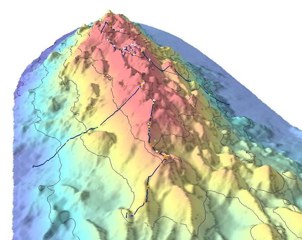
English: Bathymetric showing details of part of Davidson Seamount. The lines indicate the path of the 2002 expedition, and the dots signifigant coral nurseries
Français : Relevé bathymétrique montrant les détails du relief sous-marin du Mont Davidson. les lignes indiquent les lieux étudiés par l'expédition de 2002, et les points désignent les surseries coralliennes |
| تاریخ | import on Commons : 2010/10/30 |
| منبع | Direct link File page |
| پدیدآور | C. King/[1]/[2] |
| اجازهنامه (استفادهٔ مجدد از این پرونده) |
The above two organizations are a part of NOAA; thus it is public domain (see below) |
اجازهنامه
This image is in the public domain because it contains materials that originally came from the U.S. National Oceanic and Atmospheric Administration, taken or made as part of an employee's official duties.
|
تاریخچهٔ پرونده
روی تاریخ/زمانها کلیک کنید تا نسخهٔ مربوط به آن هنگام را ببینید.
| تاریخ/زمان | بندانگشتی | ابعاد | کاربر | توضیح | |
|---|---|---|---|---|---|
| کنونی | ۳۰ اکتبر ۲۰۱۰، ساعت ۰۸:۲۱ | | ۶۰۰ در ۴۷۸ (۵۹ کیلوبایت) | Lamiot | {{Information |Description= {{en|Bathymetric showing details of part of Davidson Seamount. The lines indicate the path of the 2002 expedition, and the dots signifigant coral nurseries}} {{fr|Relevé bathymétrique montrant les détails du relief sous-mari |
کاربرد پرونده
صفحهٔ زیر از این تصویر استفاده میکند:
کاربرد سراسری پرونده
ویکیهای دیگر زیر از این پرونده استفاده میکنند:
- کاربرد در bs.wikipedia.org
- کاربرد در en.wikipedia.org
- کاربرد در fr.wikipedia.org
- کاربرد در gl.wikipedia.org
- کاربرد در he.wikipedia.org
- کاربرد در mk.wikipedia.org
- کاربرد در nl.wikipedia.org
- کاربرد در simple.wikipedia.org
- کاربرد در sr.wikipedia.org
- کاربرد در th.wikipedia.org
- کاربرد در tr.wikipedia.org
- کاربرد در tt.wikipedia.org
- کاربرد در www.wikidata.org